Camino De Santiago (Etapa 6)

MTB
Ref..: 2019
Published: 12/05/2008
Performed: 07/07/2007
Distance in Km: 84.73
Climb in m: 647
IBP: 53 BYC
 Not from STRAVA
Near ...
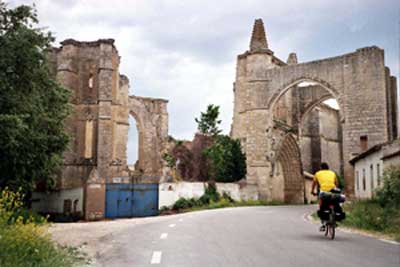
Barrio San Anton, Castrojeriz, Hinestrosa
Barrio San Anton, Castrojeriz, Hinestrosa
 No activities
This route belongs to a multi-day journey 11 days documented with 11 independent routes
You can download the tracks of this multi-day route from each of the associated stages .| Day or stage | One day stage | Distance | Climb in | IBP |
| Day 1 | 2014 Camino De Santiago (Etapa 1) | 50 Km | 2383 m | 206 |
| Day 2 | 2015 Camino De Santiago (Etapa 2) | 69 Km | 1476 m | 117 |
| Day 3 | 2016 Camino De Santiago (Etapa 3) | 69 Km | 1364 m | 91 |
| Day 4 | 2017 Camino De Santiago (Etapa 4) | 86 Km | 1472 m | 97 |
| Day 5 | 2018 Camino De Santiago (Etapa 5) | 67 Km | 513 m | 40 |
| Day 6 | 2019 Camino De Santiago (Etapa 6) (This) | 84 Km | 741 m | 64 |
| Day 7 | 2020 Camino De Santiago (Etapa 7) | 92 Km | 692 m | 66 |
| Day 8 | 2021 Camino De Santiago (Etapa 8) | 95 Km | 1615 m | 118 |
| Day 9 | 2022 Camino De Santiago (Etapa 9) | 67 Km | 1912 m | 152 |
| Day 10 | 2023 Camino De Santiago (Etapa 10) | 63 Km | 1422 m | 95 |
| Day 11 | 2024 Camino De Santiago (Etapa 11) | 54 Km | 1178 m | 84 |
| Total 11 days | 796 Km | 14768 m | 103 / dﻥa |


 list of points info

