Camino De Santiago (Etapa 1)

MTB
MTB
Ref..: 2014
Published: 12/05/2008
Performed: 01/07/2007
Distance in Km: 50.11
Climb in m: 2378
IBP: 201 BYC

Near ...
Ascarat, Caro, Ispoure, Lasse, Saint-Jean-Pied-de-Port, Saint-Michel
AngelGT
Author: AngelGT
234 published routes

Add to my Group or Club


Varios dias

This route belongs to a multi-day journey 11 days documented with 11 independent routes

You can download the tracks of this multi-day route from each of the associated stages .
 Day or stage  One day stage  Distance  Climb in  IBP
 Day 1  2014 Camino De Santiago (Etapa 1) (This)  50 Km  2383 m  206
 Day 2  2015 Camino De Santiago (Etapa 2)  69 Km  1476 m  117
 Day 3  2016 Camino De Santiago (Etapa 3)  69 Km  1364 m  91
 Day 4  2017 Camino De Santiago (Etapa 4)  86 Km  1472 m  97
 Day 5  2018 Camino De Santiago (Etapa 5)  67 Km  513 m  40
 Day 6  2019 Camino De Santiago (Etapa 6)  84 Km  741 m  64
 Day 7  2020 Camino De Santiago (Etapa 7)  92 Km  692 m  66
 Day 8  2021 Camino De Santiago (Etapa 8)  95 Km  1615 m  118
 Day 9  2022 Camino De Santiago (Etapa 9)  67 Km  1912 m  152
 Day 10  2023 Camino De Santiago (Etapa 10)  63 Km  1422 m  95
 Day 11  2024 Camino De Santiago (Etapa 11)  54 Km  1178 m  84
 Total 11 days  796 Km  14768 m  103 / día

 Height in m      Climb in %      Speed in Km/h      Speed < 2 Km/h


Description of the route


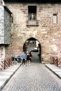
St. Jean Pied de Port, inicio del Camino Francés
ETAPA I: Saint Jean Pied de Port (Donibane Garazi) – Zubiri. 50 km.
Salimos de Saint Jean Pied de Port por la “Route de Napoleón” por la que, en cinco kilómetros, nos ponemos a 500 m. de altura llegando al albergue de Untto. Afrontamos el paso de los Pirineos con el duro y largo ascenso sin otro punto de referencia que las indicaciones jacobeas, pasando Orisson y Lepoeder, que se hace interminable; al llegar a la cima continuamos en bajada hasta Roncesvalles.
Comienza el descenso hacia Burguete y Espinal, subimos el Alto de Mezkiriz y seguimos hacia Viscarret y luego a Linzoain. Pasamos el Alto de Erro y seguimos en descenso hasta el albergue de Zubiri en donde nos quedamos a dormir. Observamos en los peregrinos a pie las típicas dolencias del camino, ampollas, quejidos y penalidades de los primeros días.


Presence of ramps


 Climbs  Distance  % of the total  Speed  Your speed would be  Time  Your time would be
   15 - 30%  4.612  9.2  15.26  ?  0:18:08  ?
   10 - 15%  4.873  9.72  15.15  ?  0:19:18  ?
   5 - 10%  7.042  14.05  15.08  ?  0:28:01  ?
   1 - 5%  7.725  15.42  14.97  ?  0:30:58  ?
   Total*  24.253 Km  48.4 %  15.09 Km/h  ? Km/h    1:36:25 h  ? h  
 Flat
   1 - -1%  4.222 Km  8.42 %  15.03 Km/h  ? Km/h    0:16:51 h  ? h  
 Descents
   -1 - -5%  8.453  16.87  15  ?  0:33:48  ?
   -5 - -10%  5.897  11.77  15.11  ?  0:23:25  ?
   -10 - -15%  2.867  5.72  15.32  ?  0:11:14  ?
   -15 - -30%  4.422  8.82  15.19  ?  0:17:28  ?
   Total*  21.639 Km  43.18 %  15.11 Km/h  ? Km/h    1:25:55 h  ? h  
* The total has not necessarily coincide with the sum of the partials after correction of errors

How long would it take you?

How long would it take you to cover this route?
There are routes without a valid time information, but with your average stats you can assess the possible duration

AngelGT to cover this route you've need a time of:   3:19:11 h 
If you sign in and have a minimum of two tracks of this same modality, you can know your time for this route, calculated from your stats..


¿Cuanto consumirá tu E-BIKE?

Entra tu E-IBP (formato n,nn)

E-IBP :   X 201 = 


 Detected activity type =  ()
 Penalization due to track conditions: 56 %   ( > 50 % = MTB, < 50 % = RDB)
 Reliability of the track: B   (2424/62/0/-/-/62)
 Correction level applied to the track: 0
DIFFICULTY OF THE ROUTE
IBP = 201 BYC
According to your statistics
 Your time in motion would be: ? h
Your average speed would be: ? Km/h
 

 Total Distance: 50.11 Km
 Analysed distance: 50.11 Km
 Linear distance: 33.85 Km

 Cumulated positive ramps: 2377.99 m  list of points info
 Cumulated negative ramps: 2032.99 m
 Maximum height: 1449 m
 Minimum height: 170 m
 Climbing Ratio: 9.8 %
 Descent ratio: 9.39 %
 Cumulated postive ramps per Km: 47.46 m
 Cumulated negative ramps per Km: 40.57 m

 Total time: 3:32:49 h
 Time in movement: 3:19:11 h
 According to your statistics
 Your time in motion would be: ? h  
 Stopped time: 0:13:38 h
 Maximum slope filter: ~30 %
 Minimum separation analysed: ~30 m
 Number of points: 1063   (cad. 47.14 m)
 Significant waypoints: 583   (cad. 85.96 m / 54.84 %)

 Changes in direction per Km: 6.13
 Changes in direction > 5º por Km: 5.29
 Cumulated straight stretches: 4.421 Km
 Straight stretches per Km: 88.23 m
 Penalized slope changes: 15
 Penalized slope changes per Km: 0.299

 Average speed in total: 14.13 Km/h
 Average speed while moving: 15.09 Km/h
 According to your statistics
 Your average speed would be: ? Km/h  
 Maximum sustained speed: 18.04 Km/h


Comments

Rapososin (65 Rutas publicadas ) (rapososin)

Hola Angel, gracias por tus publicaciones.
Tengo una pregunta sobre el track de esta etapa. A la altura de la Oficina de Turismo de Orreaga, aparece un parada de 24horas, lo que da una duración total de 25:32:47 horas ¿es un error? ¿Cuánto tiempo es el real para esta etapa?
Gracias
25/03/2013
AngelGT (234 Rutas publicadas ) (Txipo)

Hola Rapososin. Pues no me había fijado en el tiempo; efectivamente esa parada que da en Orreaga es un error ¡te aseguro que la cola en la oficina de turismo no duró 12 horas! Lo que si puedo decirte es que yo, antes de subir las rutas a Internet, le pego un repaso por el programa de edición que uso (CompeGPS) para quitar todos los tramos que no conciernen a la ruta (desvíos por error, despiste, o personales) con el fin de que la ruta subida sea el track a seguir. Los errores de tiempo pueden venir por ahí.
También te digo que, cuando hago el Camino de Santiago (por cualquiera de sus versiones) me olvido del reloj y del rendimiento, tiempos... (para eso tengo el resto del año) y me centro en disfrutar.
Para esa etapa creo recordar que estuvimos en unas cinco horas en total (descuenta paradas, comer, fotos...)
Un saludo.
26/03/2013
Guan (341 Rutas publicadas ) (Guan)

En el track original había un salto de un día en punto kilométrico 26,800, posiblemente un error en track o a la hora de guardarlo en el servidor, ya que confirmas que no hubo tal parada tan prolongada lo he modificado manualmente y publicado de nuevo, ahora en el análisis queda como una parada de 13 minutos.
Gracias por vuestros comentarios.

27/03/2013
AngelGT (234 Rutas publicadas ) (Txipo)

Gracias por la corrección Guan!!!
30/03/2013

 
My comments
:
Add comment  (Registered users)
 
Notify me answers to my comment  Do not notify answers to my comment


Share this route with a friend

Your friend will receive a message with a link to this page:
will see your email and your user name if you do it as registered user.


Write here your name (optional)

E-mail address of your friend(s). You can include various addresses separated by commas

Text or comment (optional) maximum 255 characters long, 255 Available characters

As a non registered users you need to fill-in the captcha text.
  Change image
Type the image characters.
 
 Share with a friend


Visited history

Delete history

Marked routes for review later or compare

My favorites


  Notify anomaly in this route Share in Facebook