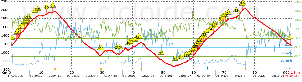
Stage Ziklo Almería-Etapa 6 Bacares-El Ramal-Venta Luisa-Cerro de la Juana-Velefique Tetica de Bacar...

MTB
MTB
Ref..: 998921
Published: 02/10/2021
Performed: 02/10/2021
Distance in Km: 92.09
Climb in m: 2723
IBP: 163 BYC

ManuLena
Author: ManuLena
285 published routes

Add to my Group or Club

 Height in m      Climb in %      Speed in Km/h      Speed < 2 Km/h

Climbs > 5%

Climbs >5% Climbs >10% Climbs >15% Climbs >20% Climbs >25%
 Steep slope of 3334 m.   Average slope  Distances  Download as waypoint
1
 Km 0.458  8%  1496 m
2
 Km 1.954  11%  105 m
3
 Km 2.059  9%  104 m
4
 Km 2.163  12%  102 m
5
 Km 2.265  8%  270 m
6
 Km 2.535  12%  763 m
7
 Km 3.298  9%  494 m
 Steep slope of 3431 m.  Average slope  Distances  Download as waypoint
8
 Km 4.111  8%  69 m
9
 Km 4.18  13%  302 m
10
 Km 4.482  9%  102 m
11
 Km 4.584  11%  102 m
12
 Km 4.686  8%  235 m
13
 Km 4.92  10%  109 m
14
 Km 5.03  9%  380 m
15
 Km 5.41  11%  410 m
16
 Km 5.821  7%  1722 m
 Steep slope of 251 m.  Average slope  Distances  Download as waypoint
17
 Km 7.942  8%  251 m
 Steep slope of 267 m.  Average slope  Distances  Download as waypoint
18
 Km 8.919  6%  267 m
 Steep slope of 441 m.  Average slope  Distances  Download as waypoint
19
 Km 11.726  6%  441 m
 Steep slope of 184 m.  Average slope  Distances  Download as waypoint
20
 Km 13.756  6%  184 m
 Steep slope of 171 m.  Average slope  Distances  Download as waypoint
21
 Km 29.311  6%  171 m
 Steep slope of 1411 m.  Average slope  Distances  Download as waypoint
22
 Km 29.596  7%  1411 m
 Steep slope of 131 m.  Average slope  Distances  Download as waypoint
23
 Km 34.726  7%  131 m
 Steep slope of 1953 m.  Average slope  Distances  Download as waypoint
24
 Km 35.72  8%  1953 m
 Steep slope of 346 m.  Average slope  Distances  Download as waypoint
25
 Km 38.536  7%  346 m
 Steep slope of 176 m.  Average slope  Distances  Download as waypoint
26
 Km 39.138  6%  176 m
 Steep slope of 533 m.  Average slope  Distances  Download as waypoint
27
 Km 39.494  7%  533 m
 Steep slope of 459 m.  Average slope  Distances  Download as waypoint
28
 Km 40.755  7%  459 m
 Steep slope of 275 m.  Average slope  Distances  Download as waypoint
29
 Km 41.316  5%  275 m
 Steep slope of 146 m.  Average slope  Distances  Download as waypoint
30
 Km 41.779  7%  146 m
 Steep slope of 223 m.  Average slope  Distances  Download as waypoint
31
 Km 42.103  6%  223 m
 Steep slope of 108 m.  Average slope  Distances  Download as waypoint
32
 Km 49.321  6%  108 m
 Steep slope of 105 m.  Average slope  Distances  Download as waypoint
33
 Km 53.999  6%  105 m
 Steep slope of 277 m.  Average slope  Distances  Download as waypoint
34
 Km 55.729  6%  277 m
 Steep slope of 199 m.  Average slope  Distances  Download as waypoint
35
 Km 57.27  6%  199 m
 Steep slope of 535 m.  Average slope  Distances  Download as waypoint
36
 Km 57.76  8%  535 m
 Steep slope of 2837 m.  Average slope  Distances  Download as waypoint
37
 Km 58.703  7%  910 m
38
 Km 59.613  16%  105 m
39
 Km 59.719  8%  105 m
40
 Km 59.824  10%  184 m
41
 Km 60.008  9%  400 m
42
 Km 60.408  10%  212 m
43
 Km 60.62  10%  243 m
44
 Km 60.863  11%  382 m
45
 Km 61.245  10%  296 m
 Steep slope of 2517 m.  Average slope  Distances  Download as waypoint
46
 Km 61.695  9%  181 m
47
 Km 61.876  10%  309 m
48
 Km 62.185  9%  584 m
49
 Km 62.768  11%  263 m
50
 Km 63.032  9%  213 m
51
 Km 63.245  11%  204 m
52
 Km 63.448  8%  763 m
 Steep slope of 729 m.  Average slope  Distances  Download as waypoint
53
 Km 64.432  6%  729 m
 Steep slope of 1235 m.  Average slope  Distances  Download as waypoint
54
 Km 65.483  7%  1033 m
55
 Km 66.515  10%  169 m
56
 Km 66.685  11%  33 m
 Steep slope of 1664 m.  Average slope  Distances  Download as waypoint
57
 Km 67.06  7%  1664 m
 Steep slope of 268 m.  Average slope  Distances  Download as waypoint
58
 Km 68.907  8%  268 m
 Steep slope of 243 m.  Average slope  Distances  Download as waypoint
59
 Km 69.435  7%  243 m
 Steep slope of 606 m.  Average slope  Distances  Download as waypoint
60
 Km 69.781  8%  606 m
 Steep slope of 625 m.  Average slope  Distances  Download as waypoint
61
 Km 70.499  6%  625 m
 Steep slope of 116 m.  Average slope  Distances  Download as waypoint
62
 Km 71.389  5%  116 m
 Steep slope of 2057 m.  Average slope  Distances  Download as waypoint
63
 Km 73.976  8%  1913 m
64
 Km 75.889  10%  106 m
65
 Km 75.995  10%  38 m
 Steep slope of 226 m.  Average slope  Distances  Download as waypoint
66
 Km 76.14  8%  226 m
 Steep slope of 143 m.  Average slope  Distances  Download as waypoint
67
 Km 91.727  7%  143 m


Description of the route


Presence of ramps


 Climbs  Distance  % of the total  Speed  Your speed would be  Time  Your time would be
   15 - 30%  0.14  0.15  8.83  ?  0:00:57  ?
   10 - 15%  4.539  4.93  9.13  ?  0:29:50  ?
   5 - 10%  24.097  26.17  11.53  ?  2:05:26  ?
   1 - 5%  13.422  14.58  17.39  ?  0:46:19  ?
   Total*  42.198 Km  45.82 %  12.5 Km/h  ? Km/h    3:22:32 h  ? h  
 Flat
   1 - -1%  6.245 Km  6.78 %  24.28 Km/h  ? Km/h    0:15:26 h  ? h  
 Descents
   -1 - -5%  16.062  17.44  35.5  ?  0:27:09  ?
   -5 - -10%  22.985  24.96  42.17  ?  0:32:42  ?
   -10 - -15%  4.346  4.72  46.84  ?  0:05:34  ?
   -15 - -30%  0.251  0.27  39.34  ?  0:00:23  ?
   Total*  43.644 Km  47.39 %  39.8 Km/h  ? Km/h    1:05:48 h  ? h  
* The total has not necessarily coincide with the sum of the partials after correction of errors

How long would it take you?

How long would it take you to cover this route?
There are routes without a valid time information, but with your average stats you can assess the possible duration

ManuLena to cover this route you've need a time of:   4:43:46 h 
If you sign in and have a minimum of two tracks of this same modality, you can know your time for this route, calculated from your stats..


¿Cuanto consumirá tu E-BIKE?

Entra tu E-IBP (formato n,nn)

E-IBP :   X 163 = 


 Detected activity type =  ()
 Penalization due to track conditions: 57 %   ( > 50 % = MTB, < 50 % = RDB)
 Reliability of the track: A   (2722/97/0/-/-/97)
 Correction level applied to the track: 0
DIFFICULTY OF THE ROUTE
IBP = 163 BYC
According to your statistics
 Your time in motion would be: ? h
Your average speed would be: ? Km/h
 

 Total Distance: 92.09 Km
 Analysed distance: 92.09 Km
 Linear distance: 0.01 Km

 Cumulated positive ramps: 2723 m  list of points info
 Cumulated negative ramps: 2729.9 m
 Maximum height: 2032.8 m
 Minimum height: 676.7 m
 Climbing Ratio: 6.45 %
 Descent ratio: 6.25 %
 Cumulated postive ramps per Km: 29.57 m
 Cumulated negative ramps per Km: 29.64 m

 Total time: 6:29:02 h
 Time in movement: 4:43:46 h
 According to your statistics
 Your time in motion would be: ? h  
 Stopped time: 1:45:16 h
 Maximum slope filter: ~30 %
 Minimum separation analysed: ~30 m
 Number of points: 7144   (cad. 12.89 m)
 Significant waypoints: 2588   (cad. 35.58 m / 36.23 %)

 Changes in direction per Km: 7.97
 Changes in direction > 5º por Km: 5.58
 Cumulated straight stretches: 19.86 Km
 Straight stretches per Km: 215.66 m
 Penalized slope changes: 15
 Penalized slope changes per Km: 0.163

 Average speed in total: 14.2 Km/h
 Average speed while moving: 19.47 Km/h
 According to your statistics
 Your average speed would be: ? Km/h  
 Maximum sustained speed: 69.9 Km/h


Comments

You can be the first one in commenting this route

 
My comments
:
Add comment  (Registered users)
 
Notify me answers to my comment  Do not notify answers to my comment


Share this route with a friend

Your friend will receive a message with a link to this page:
will see your email and your user name if you do it as registered user.


Write here your name (optional)

E-mail address of your friend(s). You can include various addresses separated by commas

Text or comment (optional) maximum 255 characters long, 255 Available characters

As a non registered users you need to fill-in the captcha text.
  Change image
Type the image characters.
 
 Share with a friend


Visited history

Delete history

Marked routes for review later or compare

My favorites


  Notify anomaly in this route Share in Facebook