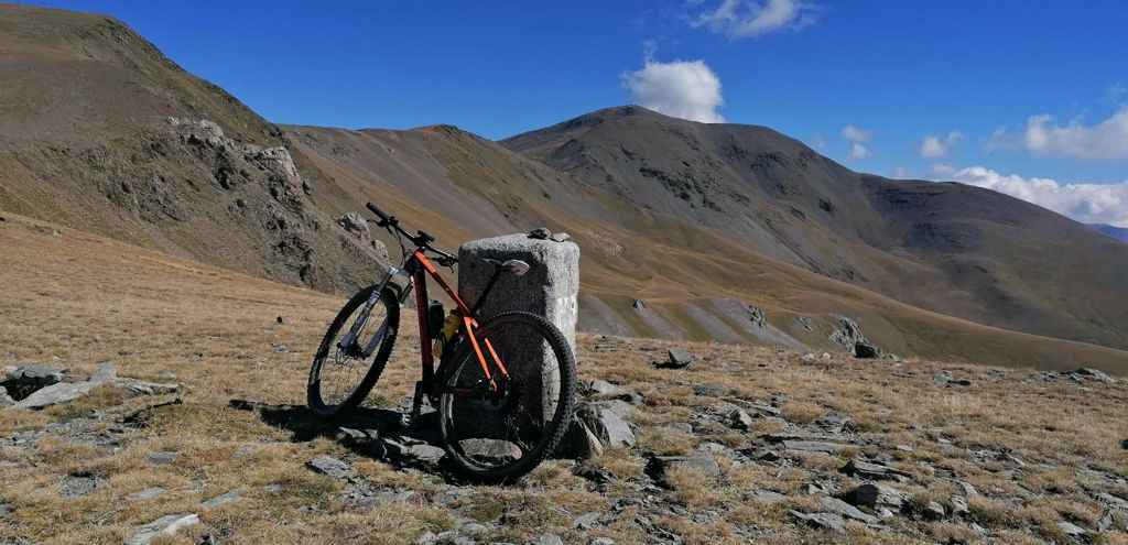
Ventola, Puigmal

MTB
MTB
Ref..: 997743
Published: 27/09/2021
Performed: 26/09/2021
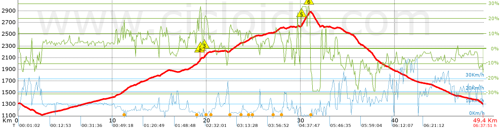
Distance in Km: 49.36
Climb in m: 1980
IBP: 149 BYC

jarcass
Author: jarcass
1338 published routes

Add to my Group or Club

 Height in m      Climb in %      Speed in Km/h      Speed < 2 Km/h

Climbs > 5%

Climbs >5% Climbs >10% Climbs >15% Climbs >20% Climbs >25%
 Steep slope of 115 m.   Average slope  Distances  Download as waypoint
1
 Km 0  13%  115 m
 Steep slope of 200 m.  Average slope  Distances  Download as waypoint
2
 Km 2.791  6%  200 m
 Steep slope of 308 m.  Average slope  Distances  Download as waypoint
3
 Km 5.214  7%  308 m
 Steep slope of 101 m.  Average slope  Distances  Download as waypoint
4
 Km 6.637  6%  101 m
 Steep slope of 233 m.  Average slope  Distances  Download as waypoint
5
 Km 10.267  13%  233 m
 Steep slope of 93 m.  Average slope  Distances  Download as waypoint
6
 Km 10.6  6%  93 m
 Steep slope of 1198 m.  Average slope  Distances  Download as waypoint
7
 Km 10.785  6%  93 m
8
 Km 10.878  12%  346 m
9
 Km 11.224  12%  181 m
10
 Km 11.405  12%  368 m
11
 Km 11.773  9%  210 m
 Steep slope of 256 m.  Average slope  Distances  Download as waypoint
12
 Km 12.093  7%  256 m
 Steep slope of 569 m.  Average slope  Distances  Download as waypoint
13
 Km 12.496  9%  253 m
14
 Km 12.749  11%  138 m
15
 Km 12.887  9%  178 m
 Steep slope of 911 m.  Average slope  Distances  Download as waypoint
16
 Km 13.25  7%  489 m
17
 Km 13.739  12%  103 m
18
 Km 13.842  8%  319 m
 Steep slope of 327 m.  Average slope  Distances  Download as waypoint
19
 Km 14.369  6%  327 m
 Steep slope of 944 m.  Average slope  Distances  Download as waypoint
20
 Km 15.026  13%  213 m
21
 Km 15.239  10%  296 m
22
 Km 15.535  11%  223 m
23
 Km 15.758  9%  212 m
 Steep slope of 566 m.  Average slope  Distances  Download as waypoint
24
 Km 17.124  7%  566 m
 Steep slope of 1442 m.  Average slope  Distances  Download as waypoint
25
 Km 18.049  9%  65 m
26
 Km 18.114  11%  189 m
27
 Km 18.304  10%  122 m
28
 Km 18.426  12%  327 m
29
 Km 18.753  5%  178 m
30
 Km 18.931  12%  37 m
31
 Km 18.968  18%  104 m
32
 Km 19.072  19%  183 m
33
 Km 19.255  28%  68 m
34
 Km 19.323  28%  33 m
35
 Km 19.356  20%  69 m
36
 Km 19.425  16%  67 m
 Steep slope of 683 m.  Average slope  Distances  Download as waypoint
37
 Km 19.672  10%  35 m
38
 Km 19.707  17%  67 m
39
 Km 19.775  20%  206 m
40
 Km 19.98  21%  104 m
41
 Km 20.084  16%  73 m
42
 Km 20.157  7%  198 m
 Steep slope of 119 m.  Average slope  Distances  Download as waypoint
43
 Km 20.635  5%  119 m
 Steep slope of 1253 m.  Average slope  Distances  Download as waypoint
44
 Km 22.393  9%  39 m
45
 Km 22.432  14%  69 m
46
 Km 22.502  16%  110 m
47
 Km 22.612  12%  633 m
48
 Km 23.245  11%  147 m
49
 Km 23.393  12%  222 m
50
 Km 23.615  9%  33 m
 Steep slope of 1199 m.  Average slope  Distances  Download as waypoint
51
 Km 24.102  8%  64 m
52
 Km 24.167  11%  111 m
53
 Km 24.278  9%  112 m
54
 Km 24.39  11%  325 m
55
 Km 24.715  7%  587 m
 Steep slope of 146 m.  Average slope  Distances  Download as waypoint
56
 Km 25.939  6%  146 m
 Steep slope of 325 m.  Average slope  Distances  Download as waypoint
57
 Km 26.232  7%  325 m
 Steep slope of 674 m.  Average slope  Distances  Download as waypoint
58
 Km 27.216  6%  111 m
59
 Km 27.327  12%  522 m
60
 Km 27.849  9%  41 m
 Steep slope of 429 m.  Average slope  Distances  Download as waypoint
61
 Km 28.473  7%  429 m
 Steep slope of 97 m.  Average slope  Distances  Download as waypoint
62
 Km 29.597  20%  97 m
 Steep slope of 1008 m.  Average slope  Distances  Download as waypoint
63
 Km 29.991  7%  40 m
64
 Km 30.032  25%  39 m
65
 Km 30.07  27%  792 m
66
 Km 30.863  22%  66 m
67
 Km 30.929  22%  71 m
 Steep slope of 115 m.  Average slope  Distances  Download as waypoint
68
 Km 32.137  12%  115 m
 Steep slope of 218 m.  Average slope  Distances  Download as waypoint
69
 Km 33.641  8%  218 m


Description of the route


Presence of ramps


 Climbs  Distance  % of the total  Speed  Your speed would be  Time  Your time would be
   15 - 30%  2.223  4.5  3.1  ?  0:42:59  ?
   10 - 15%  4.498  9.11  5.29  ?  0:51:03  ?
   5 - 10%  7.453  15.1  7.17  ?  1:02:20  ?
   1 - 5%  11.462  23.22  10.19  ?  1:07:29  ?
   Total*  25.635 Km  51.93 %  6.87 Km/h  ? Km/h    3:43:51 h  ? h  
 Flat
   1 - -1%  1.864 Km  3.78 %  10.26 Km/h  ? Km/h    0:10:54 h  ? h  
 Descents
   -1 - -5%  6.601  13.37  17  ?  0:23:18  ?
   -5 - -10%  8.134  16.48  20.77  ?  0:23:30  ?
   -10 - -15%  4.21  8.53  17.5  ?  0:14:26  ?
   -15 - -30%  2.925  5.93  8.37  ?  0:20:58  ?
   Total*  21.871 Km  44.3 %  15.96 Km/h  ? Km/h    1:22:12 h  ? h  
* The total has not necessarily coincide with the sum of the partials after correction of errors

How long would it take you?

How long would it take you to cover this route?
There are routes without a valid time information, but with your average stats you can assess the possible duration

jarcass to cover this route you've need a time of:   5:16:57 h 
If you sign in and have a minimum of two tracks of this same modality, you can know your time for this route, calculated from your stats..


¿Cuanto consumirá tu E-BIKE?

Entra tu E-IBP (formato n,nn)

E-IBP :   X 149 = 


 Detected activity type =  ()
 Penalization due to track conditions: 62 %   ( > 50 % = MTB, < 50 % = RDB)
 Reliability of the track: A   (1980/93/0/-/-/93)
 Correction level applied to the track: 0
DIFFICULTY OF THE ROUTE
IBP = 149 BYC
According to your statistics
 Your time in motion would be: ? h
Your average speed would be: ? Km/h
 

 Total Distance: 49.36 Km
 Analysed distance: 49.36 Km
 Linear distance: 0.01 Km

 Cumulated positive ramps: 1979.7 m  list of points info
 Cumulated negative ramps: 1983.2 m
 Maximum height: 2889.7 m
 Minimum height: 1116.4 m
 Climbing Ratio: 7.72 %
 Descent ratio: 9.07 %
 Cumulated postive ramps per Km: 40.11 m
 Cumulated negative ramps per Km: 40.18 m

 Total time: 6:37:51 h
 Time in movement: 5:16:57 h
 According to your statistics
 Your time in motion would be: ? h  
 Stopped time: 1:20:54 h
 Maximum slope filter: ~30 %
 Minimum separation analysed: ~30 m
 Number of points: 3247   (cad. 15.2 m)
 Significant waypoints: 1344   (cad. 36.76 m / 41.39 %)

 Changes in direction per Km: 10.49
 Changes in direction > 5º por Km: 7.03
 Cumulated straight stretches: 9.055 Km
 Straight stretches per Km: 183.45 m
 Penalized slope changes: 13
 Penalized slope changes per Km: 0.263

 Average speed in total: 7.44 Km/h
 Average speed while moving: 9.34 Km/h
 According to your statistics
 Your average speed would be: ? Km/h  
 Maximum sustained speed: 47.78 Km/h


Comments

You can be the first one in commenting this route

 
My comments
:
Add comment  (Registered users)
 
Notify me answers to my comment  Do not notify answers to my comment


Share this route with a friend

Your friend will receive a message with a link to this page:
will see your email and your user name if you do it as registered user.


Write here your name (optional)

E-mail address of your friend(s). You can include various addresses separated by commas

Text or comment (optional) maximum 255 characters long, 255 Available characters

As a non registered users you need to fill-in the captcha text.
  Change image
Type the image characters.
 
 Share with a friend


Visited history

Delete history

Marked routes for review later or compare

My favorites


  Notify anomaly in this route Share in Facebook