CICLI STA BÁRBARA-JUANET

MTB
MTB
Ref..: 995785
Published: 19/09/2021
Performed: 18/09/2021
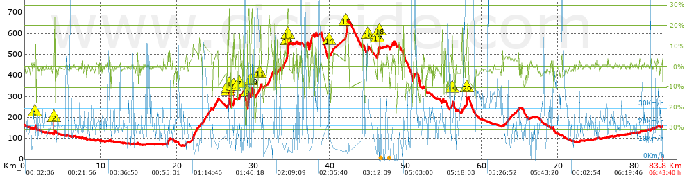
Distance in Km: 83.84
Climb in m: 1892
IBP: 168 BYC


 Height in m      Climb in %      Speed in Km/h      Speed < 2 Km/h

Climbs > 5%

Climbs >5% Climbs >10% Climbs >15% Climbs >20% Climbs >25%
 Steep slope of 118 m.   Average slope  Distances  Download as waypoint
1
 Km 1.354  11%  118 m
 Steep slope of 127 m.  Average slope  Distances  Download as waypoint
2
 Km 3.881  18%  127 m
 Steep slope of 102 m.  Average slope  Distances  Download as waypoint
3
 Km 18.788  11%  102 m
 Steep slope of 919 m.  Average slope  Distances  Download as waypoint
4
 Km 22.052  7%  919 m
 Steep slope of 662 m.  Average slope  Distances  Download as waypoint
5
 Km 24.769  8%  662 m
 Steep slope of 264 m.  Average slope  Distances  Download as waypoint
6
 Km 26.638  10%  169 m
7
 Km 26.807  27%  31 m
8
 Km 26.838  26%  64 m
 Steep slope of 180 m.  Average slope  Distances  Download as waypoint
9
 Km 27.404  16%  143 m
10
 Km 27.547  6%  37 m
 Steep slope of 109 m.  Average slope  Distances  Download as waypoint
11
 Km 27.867  6%  109 m
 Steep slope of 203 m.  Average slope  Distances  Download as waypoint
12
 Km 28.123  12%  203 m
 Steep slope of 239 m.  Average slope  Distances  Download as waypoint
13
 Km 28.577  8%  239 m
 Steep slope of 329 m.  Average slope  Distances  Download as waypoint
14
 Km 29.241  8%  41 m
15
 Km 29.281  23%  34 m
16
 Km 29.316  25%  254 m
 Steep slope of 182 m.  Average slope  Distances  Download as waypoint
17
 Km 29.684  20%  106 m
18
 Km 29.79  28%  76 m
 Steep slope of 751 m.  Average slope  Distances  Download as waypoint
19
 Km 30.285  7%  608 m
20
 Km 30.893  18%  100 m
21
 Km 30.994  8%  43 m
 Steep slope of 567 m.  Average slope  Distances  Download as waypoint
22
 Km 32.021  10%  567 m
 Steep slope of 111 m.  Average slope  Distances  Download as waypoint
23
 Km 33.15  9%  111 m
 Steep slope of 1272 m.  Average slope  Distances  Download as waypoint
24
 Km 33.456  5%  923 m
25
 Km 34.379  18%  121 m
26
 Km 34.501  28%  228 m
 Steep slope of 253 m.  Average slope  Distances  Download as waypoint
27
 Km 36.849  8%  253 m
 Steep slope of 186 m.  Average slope  Distances  Download as waypoint
28
 Km 38.073  9%  186 m
 Steep slope of 178 m.  Average slope  Distances  Download as waypoint
29
 Km 39.942  10%  138 m
30
 Km 40.08  12%  40 m
 Steep slope of 467 m.  Average slope  Distances  Download as waypoint
31
 Km 42.12  19%  426 m
32
 Km 42.545  8%  41 m
 Steep slope of 184 m.  Average slope  Distances  Download as waypoint
33
 Km 44.338  5%  184 m
 Steep slope of 162 m.  Average slope  Distances  Download as waypoint
34
 Km 45  9%  56 m
35
 Km 45.056  18%  106 m
 Steep slope of 193 m.  Average slope  Distances  Download as waypoint
36
 Km 46.391  17%  74 m
37
 Km 46.464  17%  119 m
 Steep slope of 442 m.  Average slope  Distances  Download as waypoint
38
 Km 48.011  5%  442 m
 Steep slope of 106 m.  Average slope  Distances  Download as waypoint
39
 Km 52.314  6%  106 m
 Steep slope of 194 m.  Average slope  Distances  Download as waypoint
40
 Km 54.79  9%  194 m
 Steep slope of 105 m.  Average slope  Distances  Download as waypoint
41
 Km 55.148  7%  105 m
 Steep slope of 273 m.  Average slope  Distances  Download as waypoint
42
 Km 55.922  6%  195 m
43
 Km 56.117  18%  78 m
 Steep slope of 109 m.  Average slope  Distances  Download as waypoint
44
 Km 57.388  13%  109 m
 Steep slope of 327 m.  Average slope  Distances  Download as waypoint
45
 Km 57.93  16%  285 m
46
 Km 58.215  5%  42 m


Description of the route


Presence of ramps


 Climbs  Distance  % of the total  Speed  Your speed would be  Time  Your time would be
   15 - 30%  3.189  3.8  11.38  ?  0:16:49  ?
   10 - 15%  2.096  2.5  18.23  ?  0:06:54  ?
   5 - 10%  8.278  9.87  12.17  ?  0:40:49  ?
   1 - 5%  14.217  16.96  13.01  ?  1:05:34  ?
   Total*  27.78 Km  33.13 %  12.81 Km/h  ? Km/h    2:10:06 h  ? h  
 Flat
   1 - -1%  22.997 Km  27.43 %  18.18 Km/h  ? Km/h    1:15:53 h  ? h  
 Descents
   -1 - -5%  18.912  22.56  18.77  ?  1:00:28  ?
   -5 - -10%  8.466  10.1  11.01  ?  0:46:09  ?
   -10 - -15%  3.414  4.07  19.03  ?  0:10:46  ?
   -15 - -30%  2.271  2.71  16.22  ?  0:08:24  ?
   Total*  33.062 Km  39.43 %  15.77 Km/h  ? Km/h    2:05:47 h  ? h  
* The total has not necessarily coincide with the sum of the partials after correction of errors

How long would it take you?

How long would it take you to cover this route?
There are routes without a valid time information, but with your average stats you can assess the possible duration

Kiko_Vitamina__B_&_G to cover this route you've need a time of:   5:31:46 h 
If you sign in and have a minimum of two tracks of this same modality, you can know your time for this route, calculated from your stats..


¿Cuanto consumirá tu E-BIKE?

Entra tu E-IBP (formato n,nn)

E-IBP :   X 168 = 


 Detected activity type =  ()
 Penalization due to track conditions: 79 %   ( > 50 % = MTB, < 50 % = RDB)
 Reliability of the track: C   (1919/52/0/-/-/52)
 Correction level applied to the track: 0
DIFFICULTY OF THE ROUTE
IBP = 168 BYC
According to your statistics
 Your time in motion would be: ? h
Your average speed would be: ? Km/h
 

 Total Distance: 83.84 Km
 Analysed distance: 83.84 Km
 Linear distance: 0.75 Km

 Cumulated positive ramps: 1892.37 m  list of points info
 Cumulated negative ramps: 1911.87 m
 Maximum height: 657.7 m
 Minimum height: 65.1 m
 Climbing Ratio: 6.81 %
 Descent ratio: 5.78 %
 Cumulated postive ramps per Km: 22.57 m
 Cumulated negative ramps per Km: 22.8 m

 Total time: 6:43:40 h
 Time in movement: 5:31:46 h
 According to your statistics
 Your time in motion would be: ? h  
 Stopped time: 1:11:54 h
 Maximum slope filter: ~30 %
 Minimum separation analysed: ~30 m
 Number of points: 4094   (cad. 20.48 m)
 Significant waypoints: 1689   (cad. 49.64 m / 41.26 %)

 Changes in direction per Km: 9.47
 Changes in direction > 5º por Km: 7.73
 Cumulated straight stretches: 7.135 Km
 Straight stretches per Km: 85.1 m
 Penalized slope changes: 21
 Penalized slope changes per Km: 0.25

 Average speed in total: 12.46 Km/h
 Average speed while moving: 15.16 Km/h
 According to your statistics
 Your average speed would be: ? Km/h  
 Maximum sustained speed: 87.82 Km/h


Comments

You can be the first one in commenting this route

 
My comments
:
Add comment  (Registered users)
 
Notify me answers to my comment  Do not notify answers to my comment


Share this route with a friend

Your friend will receive a message with a link to this page:
will see your email and your user name if you do it as registered user.


Write here your name (optional)

E-mail address of your friend(s). You can include various addresses separated by commas

Text or comment (optional) maximum 255 characters long, 255 Available characters

As a non registered users you need to fill-in the captcha text.
  Change image
Type the image characters.
 
 Share with a friend


Visited history

Delete history

Marked routes for review later or compare

My favorites


  Notify anomaly in this route Share in Facebook