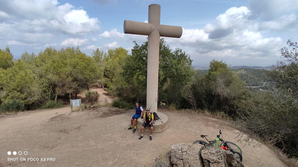
Salida con los Amigos

MTB
MTB
Ref..: 994704
Published: 15/09/2021
Performed: 14/09/2021
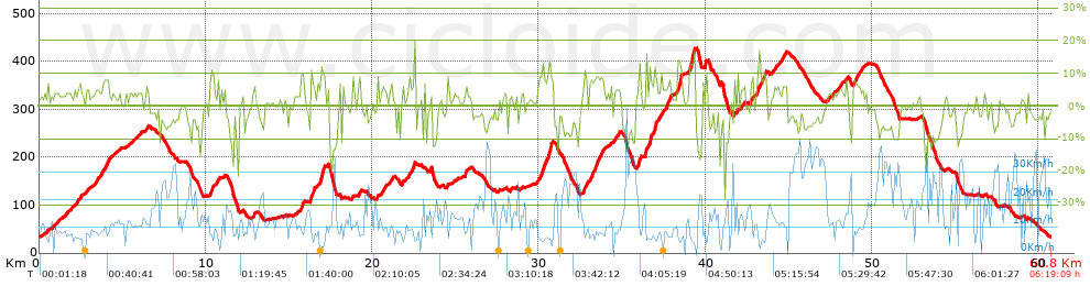
Distance in Km: 60.82
Climb in m: 1432
IBP: 98 BYC

fer72
Author: fer72
434 published routes

Add to my Group or Club

 Height in m      Climb in %      Speed in Km/h      Speed < 2 Km/h

Climbs > 5%

Climbs >5% Climbs >10% Climbs >15% Climbs >20% Climbs >25%
 Steep slope of 119 m.   Average slope  Distances  Download as waypoint
1
 Km 2.842  5%  119 m
 Steep slope of 184 m.  Average slope  Distances  Download as waypoint
2
 Km 3.437  6%  184 m
 Steep slope of 365 m.  Average slope  Distances  Download as waypoint
3
 Km 3.834  8%  365 m
 Steep slope of 216 m.  Average slope  Distances  Download as waypoint
4
 Km 10.25  8%  86 m
5
 Km 10.336  11%  130 m
 Steep slope of 172 m.  Average slope  Distances  Download as waypoint
6
 Km 10.654  7%  172 m
 Steep slope of 188 m.  Average slope  Distances  Download as waypoint
7
 Km 15.677  9%  188 m
 Steep slope of 323 m.  Average slope  Distances  Download as waypoint
8
 Km 16.258  9%  323 m
 Steep slope of 293 m.  Average slope  Distances  Download as waypoint
9
 Km 16.875  13%  255 m
10
 Km 17.13  9%  38 m
 Steep slope of 161 m.  Average slope  Distances  Download as waypoint
11
 Km 19.147  8%  161 m
 Steep slope of 246 m.  Average slope  Distances  Download as waypoint
12
 Km 20.582  6%  246 m
 Steep slope of 331 m.  Average slope  Distances  Download as waypoint
13
 Km 22.195  7%  331 m
 Steep slope of 162 m.  Average slope  Distances  Download as waypoint
14
 Km 25.559  8%  162 m
 Steep slope of 795 m.  Average slope  Distances  Download as waypoint
15
 Km 29.901  8%  653 m
16
 Km 30.554  14%  142 m
 Steep slope of 1140 m.  Average slope  Distances  Download as waypoint
17
 Km 32.651  7%  1140 m
 Steep slope of 130 m.  Average slope  Distances  Download as waypoint
18
 Km 35.998  12%  130 m
 Steep slope of 578 m.  Average slope  Distances  Download as waypoint
19
 Km 36.417  10%  235 m
20
 Km 36.652  9%  250 m
21
 Km 36.901  14%  93 m
 Steep slope of 415 m.  Average slope  Distances  Download as waypoint
22
 Km 37.04  5%  290 m
23
 Km 37.33  8%  125 m
 Steep slope of 282 m.  Average slope  Distances  Download as waypoint
24
 Km 37.666  9%  282 m
 Steep slope of 306 m.  Average slope  Distances  Download as waypoint
25
 Km 38.292  7%  39 m
26
 Km 38.331  13%  267 m
 Steep slope of 406 m.  Average slope  Distances  Download as waypoint
27
 Km 39.013  12%  156 m
28
 Km 39.17  17%  115 m
29
 Km 39.285  14%  85 m
30
 Km 39.37  7%  50 m
 Steep slope of 137 m.  Average slope  Distances  Download as waypoint
31
 Km 39.969  12%  137 m
 Steep slope of 248 m.  Average slope  Distances  Download as waypoint
32
 Km 42.121  6%  248 m
 Steep slope of 170 m.  Average slope  Distances  Download as waypoint
33
 Km 42.717  7%  170 m
 Steep slope of 594 m.  Average slope  Distances  Download as waypoint
34
 Km 43.087  8%  594 m
 Steep slope of 282 m.  Average slope  Distances  Download as waypoint
35
 Km 43.967  5%  282 m
 Steep slope of 337 m.  Average slope  Distances  Download as waypoint
36
 Km 44.564  6%  337 m
 Steep slope of 105 m.  Average slope  Distances  Download as waypoint
37
 Km 48.394  8%  105 m
 Steep slope of 589 m.  Average slope  Distances  Download as waypoint
38
 Km 48.825  7%  589 m


Description of the route


Presence of ramps


 Climbs  Distance  % of the total  Speed  Your speed would be  Time  Your time would be
   15 - 30%  0.499  0.82  4.41  ?  0:06:47  ?
   10 - 15%  2.013  3.31  6.59  ?  0:18:20  ?
   5 - 10%  8.371  13.76  8.73  ?  0:57:30  ?
   1 - 5%  16.912  27.81  10.2  ?  1:39:29  ?
   Total*  27.794 Km  45.7 %  9.16 Km/h  ? Km/h    3:02:06 h  ? h  
 Flat
   1 - -1%  8.815 Km  14.5 %  13.42 Km/h  ? Km/h    0:39:24 h  ? h  
 Descents
   -1 - -5%  11.861  19.5  17.08  ?  0:41:40  ?
   -5 - -10%  8.944  14.71  18.75  ?  0:28:37  ?
   -10 - -15%  2.601  4.28  16.09  ?  0:09:42  ?
   -15 - -30%  0.801  1.32  9.88  ?  0:04:52  ?
   Total*  24.207 Km  39.8 %  17.12 Km/h  ? Km/h    1:24:51 h  ? h  
* The total has not necessarily coincide with the sum of the partials after correction of errors

How long would it take you?

How long would it take you to cover this route?
There are routes without a valid time information, but with your average stats you can assess the possible duration

fer72 to cover this route you've need a time of:   5:06:21 h 
If you sign in and have a minimum of two tracks of this same modality, you can know your time for this route, calculated from your stats..


¿Cuanto consumirá tu E-BIKE?

Entra tu E-IBP (formato n,nn)

E-IBP :   X 98 = 


 Detected activity type =  ()
 Penalization due to track conditions: 67 %   ( > 50 % = MTB, < 50 % = RDB)
 Reliability of the track: B   (1431/70/0/-/-/70)
 Correction level applied to the track: 0
DIFFICULTY OF THE ROUTE
IBP = 98 BYC
According to your statistics
 Your time in motion would be: ? h
Your average speed would be: ? Km/h
 

 Total Distance: 60.82 Km
 Analysed distance: 60.82 Km
 Linear distance: 0.03 Km

 Cumulated positive ramps: 1431.52 m  list of points info
 Cumulated negative ramps: 1435.32 m
 Maximum height: 430.52 m
 Minimum height: 32.3 m
 Climbing Ratio: 5.15 %
 Descent ratio: 5.93 %
 Cumulated postive ramps per Km: 23.54 m
 Cumulated negative ramps per Km: 23.6 m

 Total time: 6:19:09 h
 Time in movement: 5:06:21 h
 According to your statistics
 Your time in motion would be: ? h  
 Stopped time: 1:12:48 h
 Maximum slope filter: ~30 %
 Minimum separation analysed: ~30 m
 Number of points: 2263   (cad. 26.87 m)
 Significant waypoints: 1317   (cad. 46.18 m / 58.2 %)

 Changes in direction per Km: 9.55
 Changes in direction > 5º por Km: 7.33
 Cumulated straight stretches: 8.735 Km
 Straight stretches per Km: 143.62 m
 Penalized slope changes: 17
 Penalized slope changes per Km: 0.28

 Average speed in total: 9.62 Km/h
 Average speed while moving: 11.91 Km/h
 According to your statistics
 Your average speed would be: ? Km/h  
 Maximum sustained speed: 54.79 Km/h


Comments

You can be the first one in commenting this route

 
My comments
:
Add comment  (Registered users)
 
Notify me answers to my comment  Do not notify answers to my comment


Share this route with a friend

Your friend will receive a message with a link to this page:
will see your email and your user name if you do it as registered user.


Write here your name (optional)

E-mail address of your friend(s). You can include various addresses separated by commas

Text or comment (optional) maximum 255 characters long, 255 Available characters

As a non registered users you need to fill-in the captcha text.
  Change image
Type the image characters.
 
 Share with a friend


Visited history

Delete history

Marked routes for review later or compare

My favorites


  Notify anomaly in this route Share in Facebook