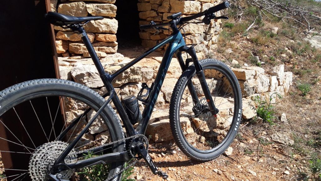
Estreno Giant!!!

MTB
MTB
Ref..: 993983
Published: 12/09/2021
Performed: 12/09/2021
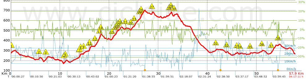
Distance in Km: 57.94
Climb in m: 1210
IBP: 79 BYC

Juan Jorge
Author: Juan Jorge
170 published routes

Add to my Group or Club

 Height in m      Climb in %      Speed in Km/h      Speed < 2 Km/h

Climbs > 5%

Climbs >5% Climbs >10% Climbs >15% Climbs >20% Climbs >25%
 Steep slope of 166 m.   Average slope  Distances  Download as waypoint
1
 Km 0.045  6%  166 m
 Steep slope of 140 m.  Average slope  Distances  Download as waypoint
2
 Km 5.718  9%  140 m
 Steep slope of 339 m.  Average slope  Distances  Download as waypoint
3
 Km 7.072  8%  339 m
 Steep slope of 122 m.  Average slope  Distances  Download as waypoint
4
 Km 10.742  10%  122 m
 Steep slope of 189 m.  Average slope  Distances  Download as waypoint
5
 Km 11.056  6%  189 m
 Steep slope of 321 m.  Average slope  Distances  Download as waypoint
6
 Km 13.86  6%  138 m
7
 Km 13.998  12%  145 m
8
 Km 14.143  7%  38 m
 Steep slope of 161 m.  Average slope  Distances  Download as waypoint
9
 Km 14.717  8%  161 m
 Steep slope of 283 m.  Average slope  Distances  Download as waypoint
10
 Km 15.852  7%  76 m
11
 Km 15.928  14%  207 m
 Steep slope of 1283 m.  Average slope  Distances  Download as waypoint
12
 Km 17.047  8%  895 m
13
 Km 17.942  12%  348 m
14
 Km 18.291  12%  40 m
 Steep slope of 452 m.  Average slope  Distances  Download as waypoint
15
 Km 20.582  8%  452 m
 Steep slope of 373 m.  Average slope  Distances  Download as waypoint
16
 Km 21.297  8%  127 m
17
 Km 21.424  11%  138 m
18
 Km 21.563  9%  108 m
 Steep slope of 109 m.  Average slope  Distances  Download as waypoint
19
 Km 21.885  5%  109 m
 Steep slope of 295 m.  Average slope  Distances  Download as waypoint
20
 Km 22.126  8%  295 m
 Steep slope of 100 m.  Average slope  Distances  Download as waypoint
21
 Km 23.252  7%  100 m
 Steep slope of 403 m.  Average slope  Distances  Download as waypoint
22
 Km 24.345  7%  403 m
 Steep slope of 965 m.  Average slope  Distances  Download as waypoint
23
 Km 25.016  7%  965 m
 Steep slope of 1074 m.  Average slope  Distances  Download as waypoint
24
 Km 26.174  8%  177 m
25
 Km 26.351  11%  147 m
26
 Km 26.498  8%  750 m
 Steep slope of 217 m.  Average slope  Distances  Download as waypoint
27
 Km 28.668  10%  217 m
 Steep slope of 230 m.  Average slope  Distances  Download as waypoint
28
 Km 32.17  7%  230 m
 Steep slope of 117 m.  Average slope  Distances  Download as waypoint
29
 Km 32.529  9%  117 m
 Steep slope of 139 m.  Average slope  Distances  Download as waypoint
30
 Km 33.134  8%  139 m
 Steep slope of 259 m.  Average slope  Distances  Download as waypoint
31
 Km 41.625  6%  259 m
 Steep slope of 116 m.  Average slope  Distances  Download as waypoint
32
 Km 43.907  6%  116 m
 Steep slope of 126 m.  Average slope  Distances  Download as waypoint
33
 Km 45.986  7%  126 m
 Steep slope of 92 m.  Average slope  Distances  Download as waypoint
34
 Km 46.581  7%  92 m
 Steep slope of 135 m.  Average slope  Distances  Download as waypoint
35
 Km 48.681  7%  135 m
 Steep slope of 172 m.  Average slope  Distances  Download as waypoint
36
 Km 51.076  6%  172 m
 Steep slope of 919 m.  Average slope  Distances  Download as waypoint
37
 Km 52.984  8%  919 m
 Steep slope of 184 m.  Average slope  Distances  Download as waypoint
38
 Km 54.347  5%  184 m


Description of the route


Presence of ramps


 Climbs  Distance  % of the total  Speed  Your speed would be  Time  Your time would be
   15 - 30%  0.078  0.13  7.6  ?  0:00:37  ?
   10 - 15%  1.686  2.91  10  ?  0:10:07  ?
   5 - 10%  8.641  14.91  11.76  ?  0:44:05  ?
   1 - 5%  13.195  22.77  16.29  ?  0:48:36  ?
   Total*  23.599 Km  40.73 %  13.69 Km/h  ? Km/h    1:43:25 h  ? h  
 Flat
   1 - -1%  8.431 Km  14.55 %  20.03 Km/h  ? Km/h    0:25:15 h  ? h  
 Descents
   -1 - -5%  15.934  27.5  25.2  ?  0:37:56  ?
   -5 - -10%  8.349  14.41  26.77  ?  0:18:43  ?
   -10 - -15%  1.377  2.38  14  ?  0:05:54  ?
   -15 - -30%  0.249  0.43  23.62  ?  0:00:38  ?
   Total*  25.91 Km  44.72 %  24.6 Km/h  ? Km/h    1:03:11 h  ? h  
* The total has not necessarily coincide with the sum of the partials after correction of errors

How long would it take you?

How long would it take you to cover this route?
There are routes without a valid time information, but with your average stats you can assess the possible duration

Juan Jorge to cover this route you've need a time of:   3:11:51 h 
If you sign in and have a minimum of two tracks of this same modality, you can know your time for this route, calculated from your stats..


¿Cuanto consumirá tu E-BIKE?

Entra tu E-IBP (formato n,nn)

E-IBP :   X 79 = 


 Detected activity type =  ()
 Penalization due to track conditions: 65 %   ( > 50 % = MTB, < 50 % = RDB)
 Reliability of the track: B   (1210/68/0/-/-/68)
 Correction level applied to the track: 0
DIFFICULTY OF THE ROUTE
IBP = 79 BYC
According to your statistics
 Your time in motion would be: ? h
Your average speed would be: ? Km/h
 

 Total Distance: 57.94 Km
 Analysed distance: 57.94 Km
 Linear distance: 0.34 Km

 Cumulated positive ramps: 1209.5 m  list of points info
 Cumulated negative ramps: 1209.4 m
 Maximum height: 704.7 m
 Minimum height: 169.3 m
 Climbing Ratio: 5.13 %
 Descent ratio: 4.67 %
 Cumulated postive ramps per Km: 20.88 m
 Cumulated negative ramps per Km: 20.87 m

 Total time: 4:17:11 h
 Time in movement: 3:11:51 h
 According to your statistics
 Your time in motion would be: ? h  
 Stopped time: 1:05:20 h
 Maximum slope filter: ~30 %
 Minimum separation analysed: ~30 m
 Number of points: 2769   (cad. 20.92 m)
 Significant waypoints: 1399   (cad. 41.42 m / 50.52 %)

 Changes in direction per Km: 9.8
 Changes in direction > 5º por Km: 7.04
 Cumulated straight stretches: 11.539 Km
 Straight stretches per Km: 199.15 m
 Penalized slope changes: 11
 Penalized slope changes per Km: 0.19

 Average speed in total: 13.52 Km/h
 Average speed while moving: 18.12 Km/h
 According to your statistics
 Your average speed would be: ? Km/h  
 Maximum sustained speed: 73.16 Km/h


Comments

You can be the first one in commenting this route

 
My comments
:
Add comment  (Registered users)
 
Notify me answers to my comment  Do not notify answers to my comment


Share this route with a friend

Your friend will receive a message with a link to this page:
will see your email and your user name if you do it as registered user.


Write here your name (optional)

E-mail address of your friend(s). You can include various addresses separated by commas

Text or comment (optional) maximum 255 characters long, 255 Available characters

As a non registered users you need to fill-in the captcha text.
  Change image
Type the image characters.
 
 Share with a friend


Visited history

Delete history

Marked routes for review later or compare

My favorites


  Notify anomaly in this route Share in Facebook