Noia-Santiago (2ª parte)

MTB
MTB
Ref..: 992410
Published: 06/09/2021
Performed: 04/09/2021
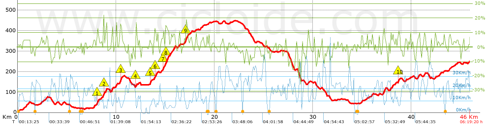
Distance in Km: 46.03
Climb in m: 1100
IBP: 84 BYC

Near ...
Alqueidon, Anxeles, Os (Santa Maria-Brion), Argalo (Santa Maria), Bastavales (San Xulian), Bendimon (San Xoan De Roo-Outes), Brion De Abaixo (San Xoan De Roo-Outes)

 Height in m      Climb in %      Speed in Km/h      Speed < 2 Km/h

Climbs > 5%

Climbs >5% Climbs >10% Climbs >15% Climbs >20% Climbs >25%
 Steep slope of 232 m.   Average slope  Distances  Download as waypoint
1
 Km 0.742  6%  232 m
 Steep slope of 116 m.  Average slope  Distances  Download as waypoint
2
 Km 1.106  5%  116 m
 Steep slope of 144 m.  Average slope  Distances  Download as waypoint
3
 Km 2.891  7%  144 m
 Steep slope of 101 m.  Average slope  Distances  Download as waypoint
4
 Km 4.579  8%  101 m
 Steep slope of 163 m.  Average slope  Distances  Download as waypoint
5
 Km 7.718  7%  163 m
 Steep slope of 240 m.  Average slope  Distances  Download as waypoint
6
 Km 8.027  7%  75 m
7
 Km 8.102  12%  122 m
8
 Km 8.224  7%  43 m
 Steep slope of 286 m.  Average slope  Distances  Download as waypoint
9
 Km 8.704  10%  40 m
10
 Km 8.744  10%  246 m
 Steep slope of 224 m.  Average slope  Distances  Download as waypoint
11
 Km 9.514  10%  224 m
 Steep slope of 111 m.  Average slope  Distances  Download as waypoint
12
 Km 10.015  13%  111 m
 Steep slope of 301 m.  Average slope  Distances  Download as waypoint
13
 Km 10.312  6%  115 m
14
 Km 10.428  13%  186 m
 Steep slope of 156 m.  Average slope  Distances  Download as waypoint
15
 Km 11.996  15%  122 m
16
 Km 12.118  7%  34 m
 Steep slope of 119 m.  Average slope  Distances  Download as waypoint
17
 Km 12.26  6%  119 m
 Steep slope of 104 m.  Average slope  Distances  Download as waypoint
18
 Km 13.455  13%  104 m
 Steep slope of 369 m.  Average slope  Distances  Download as waypoint
19
 Km 13.882  5%  64 m
20
 Km 13.946  11%  126 m
21
 Km 14.072  9%  179 m
 Steep slope of 277 m.  Average slope  Distances  Download as waypoint
22
 Km 14.582  6%  200 m
23
 Km 14.782  16%  77 m
 Steep slope of 1066 m.  Average slope  Distances  Download as waypoint
24
 Km 14.891  5%  84 m
25
 Km 14.975  7%  72 m
26
 Km 15.047  12%  296 m
27
 Km 15.344  8%  614 m
 Steep slope of 143 m.  Average slope  Distances  Download as waypoint
28
 Km 16.307  7%  143 m
 Steep slope of 370 m.  Average slope  Distances  Download as waypoint
29
 Km 16.895  6%  217 m
30
 Km 17.111  15%  153 m
 Steep slope of 427 m.  Average slope  Distances  Download as waypoint
31
 Km 17.299  5%  249 m
32
 Km 17.548  7%  178 m
 Steep slope of 115 m.  Average slope  Distances  Download as waypoint
33
 Km 20.8  7%  115 m
 Steep slope of 164 m.  Average slope  Distances  Download as waypoint
34
 Km 29.471  6%  164 m
 Steep slope of 145 m.  Average slope  Distances  Download as waypoint
35
 Km 34.936  7%  145 m
 Steep slope of 116 m.  Average slope  Distances  Download as waypoint
36
 Km 36.003  9%  116 m
 Steep slope of 107 m.  Average slope  Distances  Download as waypoint
37
 Km 36.681  7%  107 m
 Steep slope of 307 m.  Average slope  Distances  Download as waypoint
38
 Km 37.131  10%  307 m
 Steep slope of 285 m.  Average slope  Distances  Download as waypoint
39
 Km 37.881  6%  150 m
40
 Km 38.031  9%  135 m
 Steep slope of 133 m.  Average slope  Distances  Download as waypoint
41
 Km 38.357  6%  133 m
 Steep slope of 219 m.  Average slope  Distances  Download as waypoint
42
 Km 38.637  7%  30 m
43
 Km 38.667  11%  148 m
44
 Km 38.814  8%  41 m
 Steep slope of 147 m.  Average slope  Distances  Download as waypoint
45
 Km 39.412  7%  147 m
 Steep slope of 214 m.  Average slope  Distances  Download as waypoint
46
 Km 40.633  7%  214 m
 Steep slope of 163 m.  Average slope  Distances  Download as waypoint
47
 Km 41.315  8%  163 m
 Steep slope of 136 m.  Average slope  Distances  Download as waypoint
48
 Km 42.436  8%  136 m
 Steep slope of 109 m.  Average slope  Distances  Download as waypoint
49
 Km 42.858  7%  109 m
 Steep slope of 208 m.  Average slope  Distances  Download as waypoint
50
 Km 43.815  6%  208 m
 Steep slope of 134 m.  Average slope  Distances  Download as waypoint
51
 Km 45.254  7%  134 m


Description of the route


Presence of ramps


 Climbs  Distance  % of the total  Speed  Your speed would be  Time  Your time would be
   15 - 30%  0.439  0.95  5.71  ?  0:04:37  ?
   10 - 15%  2.069  4.5  7.17  ?  0:17:19  ?
   5 - 10%  6.177  13.42  11.02  ?  0:33:37  ?
   1 - 5%  11.749  25.52  15.42  ?  0:45:43  ?
   Total*  20.435 Km  44.39 %  12.11 Km/h  ? Km/h    1:41:16 h  ? h  
 Flat
   1 - -1%  9.042 Km  19.64 %  16.9 Km/h  ? Km/h    0:32:06 h  ? h  
 Descents
   -1 - -5%  9.992  21.71  21.16  ?  0:28:20  ?
   -5 - -10%  4.33  9.41  25.77  ?  0:10:05  ?
   -10 - -15%  1.844  4.01  24.14  ?  0:04:35  ?
   -15 - -30%  0.391  0.85  23.06  ?  0:01:01  ?
   Total*  16.558 Km  35.97 %  22.57 Km/h  ? Km/h    0:44:01 h  ? h  
* The total has not necessarily coincide with the sum of the partials after correction of errors

How long would it take you?

How long would it take you to cover this route?
There are routes without a valid time information, but with your average stats you can assess the possible duration

Triki Triñanes Caamaño to cover this route you've need a time of:   2:57:23 h 
If you sign in and have a minimum of two tracks of this same modality, you can know your time for this route, calculated from your stats..


¿Cuanto consumirá tu E-BIKE?

Entra tu E-IBP (formato n,nn)

E-IBP :   X 84 = 


 Detected activity type =  ()
 Penalization due to track conditions: 76 %   ( > 50 % = MTB, < 50 % = RDB)
 Reliability of the track: C   (1100/52/0/-/-/52)
 Correction level applied to the track: 0
DIFFICULTY OF THE ROUTE
IBP = 84 BYC
According to your statistics
 Your time in motion would be: ? h
Your average speed would be: ? Km/h
 

 Total Distance: 46.03 Km
 Analysed distance: 46.03 Km
 Linear distance: 27.12 Km

 Cumulated positive ramps: 1100.31 m  list of points info
 Cumulated negative ramps: 867.4 m
 Maximum height: 448.4 m
 Minimum height: 7.4 m
 Climbing Ratio: 5.38 %
 Descent ratio: 5.24 %
 Cumulated postive ramps per Km: 23.9 m
 Cumulated negative ramps per Km: 18.84 m

 Total time: 6:19:20 h
 Time in movement: 2:57:23 h
 According to your statistics
 Your time in motion would be: ? h  
 Stopped time: 3:21:57 h
 Maximum slope filter: ~30 %
 Minimum separation analysed: ~30 m
 Number of points: 2467   (cad. 18.66 m)
 Significant waypoints: 1129   (cad. 40.77 m / 45.76 %)

 Changes in direction per Km: 9.8
 Changes in direction > 5º por Km: 7.15
 Cumulated straight stretches: 9.042 Km
 Straight stretches per Km: 196.44 m
 Penalized slope changes: 9
 Penalized slope changes per Km: 0.196

 Average speed in total: 7.28 Km/h
 Average speed while moving: 15.57 Km/h
 According to your statistics
 Your average speed would be: ? Km/h  
 Maximum sustained speed: 49.83 Km/h


Comments

You can be the first one in commenting this route

 
My comments
:
Add comment  (Registered users)
 
Notify me answers to my comment  Do not notify answers to my comment


Share this route with a friend

Your friend will receive a message with a link to this page:
will see your email and your user name if you do it as registered user.


Write here your name (optional)

E-mail address of your friend(s). You can include various addresses separated by commas

Text or comment (optional) maximum 255 characters long, 255 Available characters

As a non registered users you need to fill-in the captcha text.
  Change image
Type the image characters.
 
 Share with a friend


Visited history

Delete history

Marked routes for review later or compare

My favorites


  Notify anomaly in this route Share in Facebook