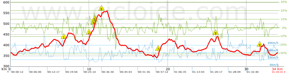
1h45' BTT --> 1 KOM + 2 Copas al zurrón...

MTB
MTB
Ref..: 985598
Published: 12/08/2021
Performed: 11/08/2021
Distance in Km: 34.02
Climb in m: 672
IBP: 52 BYC

Jeff the Killer
493 published routes

Add to my Group or Club

 Height in m      Climb in %      Speed in Km/h      Speed < 2 Km/h

Climbs > 5%

Climbs >5% Climbs >10% Climbs >15% Climbs >20% Climbs >25%
 Steep slope of 143 m.   Average slope  Distances  Download as waypoint
1
 Km 0.756  5%  143 m
 Steep slope of 105 m.  Average slope  Distances  Download as waypoint
2
 Km 1.591  8%  105 m
 Steep slope of 143 m.  Average slope  Distances  Download as waypoint
3
 Km 3.715  5%  143 m
 Steep slope of 187 m.  Average slope  Distances  Download as waypoint
4
 Km 4.836  6%  187 m
 Steep slope of 669 m.  Average slope  Distances  Download as waypoint
5
 Km 6.653  7%  79 m
6
 Km 6.732  12%  98 m
7
 Km 6.829  8%  492 m
 Steep slope of 608 m.  Average slope  Distances  Download as waypoint
8
 Km 9.57  6%  406 m
9
 Km 9.976  13%  99 m
10
 Km 10.075  8%  103 m
 Steep slope of 652 m.  Average slope  Distances  Download as waypoint
11
 Km 10.522  13%  69 m
12
 Km 10.591  17%  101 m
13
 Km 10.691  13%  173 m
14
 Km 10.864  8%  309 m
 Steep slope of 174 m.  Average slope  Distances  Download as waypoint
15
 Km 11.491  7%  38 m
16
 Km 11.529  13%  103 m
17
 Km 11.632  8%  33 m
 Steep slope of 104 m.  Average slope  Distances  Download as waypoint
18
 Km 18.168  8%  104 m
 Steep slope of 511 m.  Average slope  Distances  Download as waypoint
19
 Km 18.666  7%  143 m
20
 Km 18.809  12%  336 m
21
 Km 19.145  12%  32 m
 Steep slope of 483 m.  Average slope  Distances  Download as waypoint
22
 Km 24.936  8%  483 m
 Steep slope of 177 m.  Average slope  Distances  Download as waypoint
23
 Km 26.015  11%  109 m
24
 Km 26.125  12%  68 m
 Steep slope of 124 m.  Average slope  Distances  Download as waypoint
25
 Km 30.496  5%  124 m
 Steep slope of 241 m.  Average slope  Distances  Download as waypoint
26
 Km 31.63  6%  34 m
27
 Km 31.664  13%  137 m
28
 Km 31.8  10%  70 m
 Steep slope of 103 m.  Average slope  Distances  Download as waypoint
29
 Km 32.074  10%  103 m


Description of the route


Presence of ramps


 Climbs  Distance  % of the total  Speed  Your speed would be  Time  Your time would be
   15 - 30%  0.303  0.89  8.72  ?  0:02:05  ?
   10 - 15%  1.235  3.63  9.64  ?  0:07:41  ?
   5 - 10%  3.527  10.37  12.89  ?  0:16:25  ?
   1 - 5%  7.66  22.52  19.02  ?  0:24:10  ?
   Total*  12.724 Km  37.41 %  15.16 Km/h  ? Km/h    0:50:21 h  ? h  
 Flat
   1 - -1%  7.756 Km  22.8 %  22.7 Km/h  ? Km/h    0:20:30 h  ? h  
 Descents
   -1 - -5%  8.599  25.28  24.71  ?  0:20:53  ?
   -5 - -10%  3.433  10.09  25.48  ?  0:08:05  ?
   -10 - -15%  1.233  3.62  17.75  ?  0:04:10  ?
   -15 - -30%  0.271  0.8  15.71  ?  0:01:02  ?
   Total*  13.535 Km  39.79 %  23.77 Km/h  ? Km/h    0:34:10 h  ? h  
* The total has not necessarily coincide with the sum of the partials after correction of errors

How long would it take you?

How long would it take you to cover this route?
There are routes without a valid time information, but with your average stats you can assess the possible duration

Jeff the Killer to cover this route you've need a time of:   1:45:01 h 
If you sign in and have a minimum of two tracks of this same modality, you can know your time for this route, calculated from your stats..


¿Cuanto consumirá tu E-BIKE?

Entra tu E-IBP (formato n,nn)

E-IBP :   X 52 = 


 Detected activity type =  ()
 Penalization due to track conditions: 71 %   ( > 50 % = MTB, < 50 % = RDB)
 Reliability of the track: B   (672/59/0/-/-/59)
 Correction level applied to the track: 0
DIFFICULTY OF THE ROUTE
IBP = 52 BYC
According to your statistics
 Your time in motion would be: ? h
Your average speed would be: ? Km/h
 

 Total Distance: 34.02 Km
 Analysed distance: 34.02 Km
 Linear distance: 0 Km

 Cumulated positive ramps: 671.7 m  list of points info
 Cumulated negative ramps: 665.4 m
 Maximum height: 560.8 m
 Minimum height: 340.8 m
 Climbing Ratio: 5.28 %
 Descent ratio: 4.92 %
 Cumulated postive ramps per Km: 19.74 m
 Cumulated negative ramps per Km: 19.56 m

 Total time: 1:45:01 h
 Time in movement: 1:45:01 h
 According to your statistics
 Your time in motion would be: ? h  
 Stopped time: 0:00:00 h
 Maximum slope filter: ~30 %
 Minimum separation analysed: ~30 m
 Number of points: 2585   (cad. 13.16 m)
 Significant waypoints: 938   (cad. 36.26 m / 36.29 %)

 Changes in direction per Km: 10.99
 Changes in direction > 5º por Km: 7.94
 Cumulated straight stretches: 7.12 Km
 Straight stretches per Km: 209.29 m
 Penalized slope changes: 7
 Penalized slope changes per Km: 0.206

 Average speed in total: 19.43 Km/h
 Average speed while moving: 19.44 Km/h
 According to your statistics
 Your average speed would be: ? Km/h  
 Maximum sustained speed: 39.51 Km/h


Comments

You can be the first one in commenting this route

 
My comments
:
Add comment  (Registered users)
 
Notify me answers to my comment  Do not notify answers to my comment


Share this route with a friend

Your friend will receive a message with a link to this page:
will see your email and your user name if you do it as registered user.


Write here your name (optional)

E-mail address of your friend(s). You can include various addresses separated by commas

Text or comment (optional) maximum 255 characters long, 255 Available characters

As a non registered users you need to fill-in the captcha text.
  Change image
Type the image characters.
 
 Share with a friend


Visited history

Delete history

Marked routes for review later or compare

My favorites


  Notify anomaly in this route Share in Facebook