Collsuspina (la Pullosa)

Road
Road
Ref..: 982700
Published: 01/08/2021
Performed: 31/07/2021
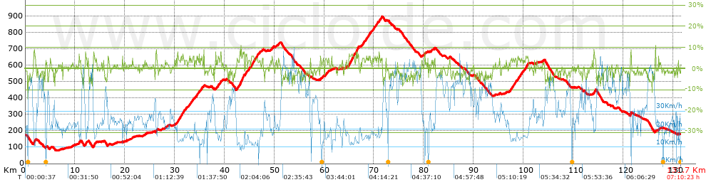
Distance in Km: 131.69
Climb in m: 1721
IBP: 123 BYC

Santi Dongil Diaz
926 published routes

Add to my Group or Club

 Height in m      Climb in %      Speed in Km/h      Speed < 2 Km/h

Climbs > 5%

Climbs >5% Climbs >10% Climbs >15% Climbs >20% Climbs >25%
 Steep slope of 350 m.   Average slope  Distances  Download as waypoint
1
 Km 1.738  7%  350 m
 Steep slope of 114 m.  Average slope  Distances  Download as waypoint
2
 Km 10.832  7%  114 m
 Steep slope of 273 m.  Average slope  Distances  Download as waypoint
3
 Km 12.087  6%  273 m
 Steep slope of 256 m.  Average slope  Distances  Download as waypoint
4
 Km 13.712  7%  256 m
 Steep slope of 186 m.  Average slope  Distances  Download as waypoint
5
 Km 26.247  6%  186 m
 Steep slope of 221 m.  Average slope  Distances  Download as waypoint
6
 Km 30.539  6%  221 m
 Steep slope of 148 m.  Average slope  Distances  Download as waypoint
7
 Km 31.171  5%  148 m
 Steep slope of 152 m.  Average slope  Distances  Download as waypoint
8
 Km 31.469  5%  152 m
 Steep slope of 150 m.  Average slope  Distances  Download as waypoint
9
 Km 31.737  5%  150 m
 Steep slope of 185 m.  Average slope  Distances  Download as waypoint
10
 Km 32.942  5%  185 m
 Steep slope of 195 m.  Average slope  Distances  Download as waypoint
11
 Km 33.637  5%  195 m
 Steep slope of 251 m.  Average slope  Distances  Download as waypoint
12
 Km 34.383  5%  251 m
 Steep slope of 108 m.  Average slope  Distances  Download as waypoint
13
 Km 35.353  6%  108 m
 Steep slope of 107 m.  Average slope  Distances  Download as waypoint
14
 Km 35.812  6%  107 m
 Steep slope of 223 m.  Average slope  Distances  Download as waypoint
15
 Km 38.708  6%  223 m
 Steep slope of 152 m.  Average slope  Distances  Download as waypoint
16
 Km 39.207  7%  152 m
 Steep slope of 104 m.  Average slope  Distances  Download as waypoint
17
 Km 42.478  7%  104 m
 Steep slope of 872 m.  Average slope  Distances  Download as waypoint
18
 Km 43.047  7%  872 m
 Steep slope of 233 m.  Average slope  Distances  Download as waypoint
19
 Km 44.191  6%  233 m
 Steep slope of 145 m.  Average slope  Distances  Download as waypoint
20
 Km 44.857  5%  145 m
 Steep slope of 499 m.  Average slope  Distances  Download as waypoint
21
 Km 45.357  6%  499 m
 Steep slope of 131 m.  Average slope  Distances  Download as waypoint
22
 Km 45.957  6%  131 m
 Steep slope of 367 m.  Average slope  Distances  Download as waypoint
23
 Km 46.373  6%  367 m
 Steep slope of 109 m.  Average slope  Distances  Download as waypoint
24
 Km 59.24  7%  109 m
 Steep slope of 1027 m.  Average slope  Distances  Download as waypoint
25
 Km 65.043  6%  1027 m
 Steep slope of 535 m.  Average slope  Distances  Download as waypoint
26
 Km 66.426  7%  535 m
 Steep slope of 196 m.  Average slope  Distances  Download as waypoint
27
 Km 67.87  5%  196 m
 Steep slope of 117 m.  Average slope  Distances  Download as waypoint
28
 Km 68.399  5%  117 m
 Steep slope of 191 m.  Average slope  Distances  Download as waypoint
29
 Km 68.738  5%  191 m
 Steep slope of 120 m.  Average slope  Distances  Download as waypoint
30
 Km 69.125  6%  120 m
 Steep slope of 184 m.  Average slope  Distances  Download as waypoint
31
 Km 70.212  5%  184 m
 Steep slope of 182 m.  Average slope  Distances  Download as waypoint
32
 Km 70.61  5%  182 m
 Steep slope of 123 m.  Average slope  Distances  Download as waypoint
33
 Km 71.012  6%  123 m
 Steep slope of 102 m.  Average slope  Distances  Download as waypoint
34
 Km 71.354  5%  102 m
 Steep slope of 154 m.  Average slope  Distances  Download as waypoint
35
 Km 98.265  6%  154 m
 Steep slope of 161 m.  Average slope  Distances  Download as waypoint
36
 Km 99.081  5%  161 m
 Steep slope of 195 m.  Average slope  Distances  Download as waypoint
37
 Km 100.378  5%  195 m
 Steep slope of 274 m.  Average slope  Distances  Download as waypoint
38
 Km 100.673  5%  274 m
 Steep slope of 138 m.  Average slope  Distances  Download as waypoint
39
 Km 114.13  6%  138 m
 Steep slope of 109 m.  Average slope  Distances  Download as waypoint
40
 Km 114.37  6%  109 m
 Steep slope of 188 m.  Average slope  Distances  Download as waypoint
41
 Km 121.457  7%  188 m


Description of the route


Presence of ramps


 Climbs  Distance  % of the total  Speed  Your speed would be  Time  Your time would be
   15 - 30%  0  0  0  ?  0:00:00  ?
   10 - 15%  0.109  0.08  12.25  ?  0:00:32  ?
   5 - 10%  11.631  8.83  14.57  ?  0:47:54  ?
   1 - 5%  34.994  26.57  18.69  ?  1:52:21  ?
   Total*  46.734 Km  35.49 %  17.44 Km/h  ? Km/h    2:40:47 h  ? h  
 Flat
   1 - -1%  35.092 Km  26.65 %  25.97 Km/h  ? Km/h    1:21:05 h  ? h  
 Descents
   -1 - -5%  40.769  30.96  37.23  ?  1:05:42  ?
   -5 - -10%  8.651  6.57  46.34  ?  0:11:12  ?
   -10 - -15%  0.444  0.34  37.14  ?  0:00:43  ?
   -15 - -30%  0  0  0  ?  0:00:00  ?
   Total*  49.864 Km  37.86 %  38.55 Km/h  ? Km/h    1:17:37 h  ? h  
* The total has not necessarily coincide with the sum of the partials after correction of errors

How long would it take you?

How long would it take you to cover this route?
There are routes without a valid time information, but with your average stats you can assess the possible duration

Santi Dongil Diaz to cover this route you've need a time of:   5:19:29 h 
If you sign in and have a minimum of two tracks of this same modality, you can know your time for this route, calculated from your stats..


¿Cuanto consumirá tu E-BIKE?

Entra tu E-IBP (formato n,nn)

E-IBP :   X 123 = 


 Detected activity type =  ()
 Penalization due to track conditions: 40 %   ( > 50 % = MTB, < 50 % = RDB)
 Reliability of the track: A   (1720/79/0/-/-/79)
 Correction level applied to the track: 0
DIFFICULTY OF THE ROUTE
IBP = 123 BYC
According to your statistics
 Your time in motion would be: ? h
Your average speed would be: ? Km/h
 

 Total Distance: 131.69 Km
 Analysed distance: 131.69 Km
 Linear distance: 0.03 Km

 Cumulated positive ramps: 1720.6 m  list of points info
 Cumulated negative ramps: 1720.8 m
 Maximum height: 897.8 m
 Minimum height: 80.2 m
 Climbing Ratio: 3.68 %
 Descent ratio: 3.45 %
 Cumulated postive ramps per Km: 13.07 m
 Cumulated negative ramps per Km: 13.07 m

 Total time: 7:10:23 h
 Time in movement: 5:19:29 h
 According to your statistics
 Your time in motion would be: ? h  
 Stopped time: 1:50:54 h
 Maximum slope filter: ~30 %
 Minimum separation analysed: ~30 m
 Number of points: 9736   (cad. 13.53 m)
 Significant waypoints: 3643   (cad. 36.15 m / 37.42 %)

 Changes in direction per Km: 9.25
 Changes in direction > 5º por Km: 4.91
 Cumulated straight stretches: 50.699 Km
 Straight stretches per Km: 384.99 m
 Penalized slope changes: 17
 Penalized slope changes per Km: 0.129

 Average speed in total: 18.36 Km/h
 Average speed while moving: 24.73 Km/h
 According to your statistics
 Your average speed would be: ? Km/h  
 Maximum sustained speed: 63.92 Km/h


Comments

You can be the first one in commenting this route

 
My comments
:
Add comment  (Registered users)
 
Notify me answers to my comment  Do not notify answers to my comment


Share this route with a friend

Your friend will receive a message with a link to this page:
will see your email and your user name if you do it as registered user.


Write here your name (optional)

E-mail address of your friend(s). You can include various addresses separated by commas

Text or comment (optional) maximum 255 characters long, 255 Available characters

As a non registered users you need to fill-in the captcha text.
  Change image
Type the image characters.
 
 Share with a friend


Visited history

Delete history

Marked routes for review later or compare

My favorites


  Notify anomaly in this route Share in Facebook