Els Motllats - Mont-ral - Mas d'en Toni - Barrulles - Prades - La Febró - Pla Agustench - Els Motlla...

MTB
MTB
Ref..: 976662
Published: 10/07/2021
Performed: 10/07/2021
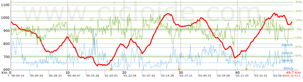
Distance in Km: 49.74
Climb in m: 1301
IBP: 94 BYC

PereBor
Author: PereBor
457 published routes

Add to my Group or Club

 Height in m      Climb in %      Speed in Km/h      Speed < 2 Km/h

Climbs > 5%

Climbs >5% Climbs >10% Climbs >15% Climbs >20% Climbs >25%
 Steep slope of 257 m.   Average slope  Distances  Download as waypoint
1
 Km 8.388  7%  257 m
 Steep slope of 289 m.  Average slope  Distances  Download as waypoint
2
 Km 8.815  8%  289 m
 Steep slope of 483 m.  Average slope  Distances  Download as waypoint
3
 Km 9.298  6%  483 m
 Steep slope of 293 m.  Average slope  Distances  Download as waypoint
4
 Km 17.353  9%  293 m
 Steep slope of 509 m.  Average slope  Distances  Download as waypoint
5
 Km 17.758  8%  509 m
 Steep slope of 522 m.  Average slope  Distances  Download as waypoint
6
 Km 18.375  14%  113 m
7
 Km 18.488  8%  123 m
8
 Km 18.61  11%  110 m
9
 Km 18.72  11%  176 m
 Steep slope of 299 m.  Average slope  Distances  Download as waypoint
10
 Km 19.024  11%  118 m
11
 Km 19.142  7%  181 m
 Steep slope of 670 m.  Average slope  Distances  Download as waypoint
12
 Km 20.509  10%  243 m
13
 Km 20.752  13%  248 m
14
 Km 21  11%  179 m
 Steep slope of 99 m.  Average slope  Distances  Download as waypoint
15
 Km 23.272  9%  99 m
 Steep slope of 400 m.  Average slope  Distances  Download as waypoint
16
 Km 23.645  8%  400 m
 Steep slope of 1278 m.  Average slope  Distances  Download as waypoint
17
 Km 24.547  8%  40 m
18
 Km 24.587  15%  114 m
19
 Km 24.701  11%  330 m
20
 Km 25.03  9%  323 m
21
 Km 25.354  11%  139 m
22
 Km 25.492  8%  249 m
23
 Km 25.741  12%  83 m
 Steep slope of 371 m.  Average slope  Distances  Download as waypoint
24
 Km 25.951  6%  197 m
25
 Km 26.148  13%  174 m
 Steep slope of 237 m.  Average slope  Distances  Download as waypoint
26
 Km 26.523  6%  237 m
 Steep slope of 166 m.  Average slope  Distances  Download as waypoint
27
 Km 26.869  8%  166 m
 Steep slope of 160 m.  Average slope  Distances  Download as waypoint
28
 Km 31.747  7%  160 m
 Steep slope of 223 m.  Average slope  Distances  Download as waypoint
29
 Km 32.73  6%  38 m
30
 Km 32.768  11%  151 m
31
 Km 32.92  11%  34 m
 Steep slope of 188 m.  Average slope  Distances  Download as waypoint
32
 Km 33.257  9%  188 m
 Steep slope of 113 m.  Average slope  Distances  Download as waypoint
33
 Km 38.283  7%  113 m
 Steep slope of 344 m.  Average slope  Distances  Download as waypoint
34
 Km 40.379  9%  344 m
 Steep slope of 376 m.  Average slope  Distances  Download as waypoint
35
 Km 41.494  7%  376 m
 Steep slope of 357 m.  Average slope  Distances  Download as waypoint
36
 Km 41.972  8%  197 m
37
 Km 42.17  11%  118 m
38
 Km 42.288  13%  42 m
 Steep slope of 312 m.  Average slope  Distances  Download as waypoint
39
 Km 42.76  8%  312 m
 Steep slope of 174 m.  Average slope  Distances  Download as waypoint
40
 Km 43.308  8%  174 m
 Steep slope of 379 m.  Average slope  Distances  Download as waypoint
41
 Km 43.58  6%  306 m
42
 Km 43.887  16%  73 m
 Steep slope of 926 m.  Average slope  Distances  Download as waypoint
43
 Km 44.155  7%  504 m
44
 Km 44.659  13%  146 m
45
 Km 44.805  8%  276 m
 Steep slope of 306 m.  Average slope  Distances  Download as waypoint
46
 Km 45.776  7%  306 m
 Steep slope of 112 m.  Average slope  Distances  Download as waypoint
47
 Km 46.185  10%  112 m
 Steep slope of 106 m.  Average slope  Distances  Download as waypoint
48
 Km 46.778  8%  106 m
 Steep slope of 110 m.  Average slope  Distances  Download as waypoint
49
 Km 47.368  7%  110 m
 Steep slope of 181 m.  Average slope  Distances  Download as waypoint
50
 Km 49.406  6%  181 m


Description of the route


Presence of ramps


 Climbs  Distance  % of the total  Speed  Your speed would be  Time  Your time would be
   15 - 30%  0.405  0.82  5.19  ?  0:04:41  ?
   10 - 15%  2.956  5.94  5.95  ?  0:29:50  ?
   5 - 10%  7.954  15.99  8.71  ?  0:54:48  ?
   1 - 5%  11.158  22.43  12.59  ?  0:53:11  ?
   Total*  22.474 Km  45.18 %  9.46 Km/h  ? Km/h    2:22:30 h  ? h  
 Flat
   1 - -1%  6.545 Km  13.16 %  15.93 Km/h  ? Km/h    0:24:39 h  ? h  
 Descents
   -1 - -5%  9.089  18.27  19.25  ?  0:28:20  ?
   -5 - -10%  8.109  16.3  18.38  ?  0:26:28  ?
   -10 - -15%  2.753  5.53  16.74  ?  0:09:52  ?
   -15 - -30%  0.769  1.55  13.37  ?  0:03:27  ?
   Total*  20.72 Km  41.66 %  18.25 Km/h  ? Km/h    1:08:07 h  ? h  
* The total has not necessarily coincide with the sum of the partials after correction of errors

How long would it take you?

How long would it take you to cover this route?
There are routes without a valid time information, but with your average stats you can assess the possible duration

PereBor to cover this route you've need a time of:   3:55:16 h 
If you sign in and have a minimum of two tracks of this same modality, you can know your time for this route, calculated from your stats..


¿Cuanto consumirá tu E-BIKE?

Entra tu E-IBP (formato n,nn)

E-IBP :   X 94 = 


 Detected activity type =  ()
 Penalization due to track conditions: 70 %   ( > 50 % = MTB, < 50 % = RDB)
 Reliability of the track: B   (1301/69/0/-/-/69)
 Correction level applied to the track: 0
DIFFICULTY OF THE ROUTE
IBP = 94 BYC
According to your statistics
 Your time in motion would be: ? h
Your average speed would be: ? Km/h
 

 Total Distance: 49.74 Km
 Analysed distance: 49.74 Km
 Linear distance: 0.01 Km

 Cumulated positive ramps: 1301.2 m  list of points info
 Cumulated negative ramps: 1305.4 m
 Maximum height: 1038.4 m
 Minimum height: 629.8 m
 Climbing Ratio: 5.79 %
 Descent ratio: 6.3 %
 Cumulated postive ramps per Km: 26.16 m
 Cumulated negative ramps per Km: 26.24 m

 Total time: 4:10:43 h
 Time in movement: 3:55:16 h
 According to your statistics
 Your time in motion would be: ? h  
 Stopped time: 0:15:27 h
 Maximum slope filter: ~30 %
 Minimum separation analysed: ~30 m
 Number of points: 2798   (cad. 17.78 m)
 Significant waypoints: 1277   (cad. 38.95 m / 45.64 %)

 Changes in direction per Km: 11.3
 Changes in direction > 5º por Km: 8.69
 Cumulated straight stretches: 6.313 Km
 Straight stretches per Km: 126.92 m
 Penalized slope changes: 14
 Penalized slope changes per Km: 0.281

 Average speed in total: 11.9 Km/h
 Average speed while moving: 12.69 Km/h
 According to your statistics
 Your average speed would be: ? Km/h  
 Maximum sustained speed: 50.07 Km/h


Comments

You can be the first one in commenting this route

 
My comments
:
Add comment  (Registered users)
 
Notify me answers to my comment  Do not notify answers to my comment


Share this route with a friend

Your friend will receive a message with a link to this page:
will see your email and your user name if you do it as registered user.


Write here your name (optional)

E-mail address of your friend(s). You can include various addresses separated by commas

Text or comment (optional) maximum 255 characters long, 255 Available characters

As a non registered users you need to fill-in the captcha text.
  Change image
Type the image characters.
 
 Share with a friend


Visited history

Delete history

Marked routes for review later or compare

My favorites


  Notify anomaly in this route Share in Facebook