Transpirenaica en BTT 17 Etxalar - Hondarribia - Irún

MTB
MTB
Ref..: 9681
Published: 14/07/2012
Performed: 11/07/2012
Distance in Km: 49.58
Climb in m: 1175
IBP: 109 BYC

Near ...
Etxalar, Gorosurreta, Lakain-Apezborro, Larrapil-Sarriku, Lurriztiederra, Orizki
zinaztli
Author: zinaztli
480 published routes

Add to my Group or Club


Varios dias

This route belongs to a multi-day journey 17 days documented with 17 independent routes

You can download the tracks of this multi-day route from each of the associated stages .
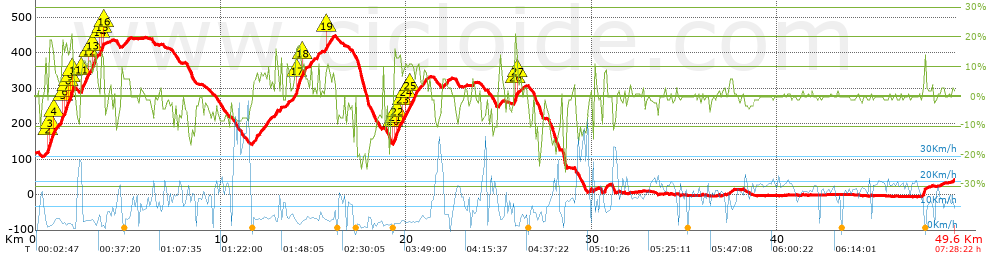
 Day or stage  One day stage  Distance  Climb in  IBP
 Day 1  9665 Transpirenaica en BTT 01 Llança - Albanya  67 Km  1618 m  111
 Day 2  9666 Transpirenaica en BTT 02 Albanya - Camprodón  56 Km  1961 m  133
 Day 3  9667 Transpirenaica en BTT 03 Camprodón - Planoles  62 Km  1894 m  120
 Day 4  9668 Transpirenaica en BTT 04 Planoles - Baga  57 Km  1827 m  129
 Day 5  9669 Transpirenaica en BTT 05 Baga - Pla de Sant Tirs  67 Km  1848 m  120
 Day 6  9670 Transpirenaica en BTT 06 Pla de Sant Tirs - Llavorsi  58 Km  1515 m  101
 Day 7  9671 Transpirenaica en BTT 07 Llavorsi - Torre de Cabdella  61 Km  1787 m  107
 Day 8  9672 Transpirenaica en BTT 08 Torre de Cabdella - Pont de Suert  49 Km  1546 m  107
 Day 9  9673 Transpirenaica en BTT 09 Pont de Suert - Campo  57 Km  1425 m  102
 Day 10  9674 Transpirenaica en BTT 10 Campo - Nerín  54 Km  2066 m  139
 Day 11  9675 Transpirenaica en BTT 11 Nerín - Fiscal  49 Km  1152 m  71
 Day 12  9676 Transpirenaica en BTT 12 Fiscal - Senegüe  50 Km  1331 m  89
 Day 13  9677 Transpirenaica en BTT 13 Senegüe - Aragües del Puerto  58 Km  1673 m  117
 Day 14  9678 Transpirenaica en BTT 14 Aragües del Puerto - Isaba  52 Km  1502 m  110
 Day 15  9679 Transpirenaica en BTT 15 Isaba - Roncesvalles  73 Km  1688 m  105
 Day 16  9680 Transpirenaica en BTT 16 Roncesvalles - Etxalar  68 Km  1791 m  154
 Day 17  9681 Transpirenaica en BTT 17 Etxalar - Hondarribia - Irún (This)  49 Km  1220 m  112
 Total 17 days  987 Km  27844 m  113 / día

 Height in m      Climb in %      Speed in Km/h      Speed < 2 Km/h


Description of the route


Presence of ramps


 Climbs  Distance  % of the total  Speed  Your speed would be  Time  Your time would be
   15 - 30%  1.46  2.94  4.47  ?  0:19:36  ?
   10 - 15%  3.289  6.63  5.41  ?  0:36:27  ?
   5 - 10%  4.373  8.82  6.5  ?  0:40:21  ?
   1 - 5%  8.024  16.18  9.45  ?  0:50:58  ?
   Total*  17.145 Km  34.58 %  6.98 Km/h  ? Km/h    2:27:22 h  ? h  
 Flat
   1 - -1%  15.083 Km  30.42 %  14.8 Km/h  ? Km/h    1:01:09 h  ? h  
 Descents
   -1 - -5%  7.239  14.6  12.57  ?  0:34:34  ?
   -5 - -10%  6.102  12.31  15.18  ?  0:24:07  ?
   -10 - -15%  2.425  4.89  10.42  ?  0:13:58  ?
   -15 - -30%  1.585  3.2  4.78  ?  0:19:53  ?
   Total*  17.35 Km  35 %  11.25 Km/h  ? Km/h    1:32:32 h  ? h  
* The total has not necessarily coincide with the sum of the partials after correction of errors

How long would it take you?

How long would it take you to cover this route?
There are routes without a valid time information, but with your average stats you can assess the possible duration

zinaztli to cover this route you've need a time of:   5:01:03 h 
If you sign in and have a minimum of two tracks of this same modality, you can know your time for this route, calculated from your stats..


¿Cuanto consumirá tu E-BIKE?

Entra tu E-IBP (formato n,nn)

E-IBP :   X 109 = 


 Detected activity type =  ()
 Penalization due to track conditions: 71 %   ( > 50 % = MTB, < 50 % = RDB)
 Reliability of the track: B   (1175/60/0/-/-/60)
 Correction level applied to the track: 0
DIFFICULTY OF THE ROUTE
IBP = 109 BYC
According to your statistics
 Your time in motion would be: ? h
Your average speed would be: ? Km/h
 

 Total Distance: 49.58 Km
 Analysed distance: 49.58 Km
 Linear distance: 17.39 Km

 Cumulated positive ramps: 1175 m  list of points info
 Cumulated negative ramps: 1248.1 m
 Maximum height: 448.1 m
 Minimum height: -6.3 m
 Climbing Ratio: 6.85 %
 Descent ratio: 7.19 %
 Cumulated postive ramps per Km: 23.7 m
 Cumulated negative ramps per Km: 25.17 m

 Total time: 7:28:22 h
 Time in movement: 5:01:03 h
 According to your statistics
 Your time in motion would be: ? h  
 Stopped time: 2:27:19 h
 Maximum slope filter: ~30 %
 Minimum separation analysed: ~30 m
 Number of points: 1735   (cad. 28.58 m)
 Significant waypoints: 1025   (cad. 48.37 m / 59.08 %)

 Changes in direction per Km: 9.76
 Changes in direction > 5º por Km: 7.08
 Cumulated straight stretches: 7.486 Km
 Straight stretches per Km: 150.99 m
 Penalized slope changes: 9
 Penalized slope changes per Km: 0.182

 Average speed in total: 6.63 Km/h
 Average speed while moving: 9.88 Km/h
 According to your statistics
 Your average speed would be: ? Km/h  
 Maximum sustained speed: 42.72 Km/h


Comments

You can be the first one in commenting this route

 
My comments
:
Add comment  (Registered users)
 
Notify me answers to my comment  Do not notify answers to my comment


Share this route with a friend

Your friend will receive a message with a link to this page:
will see your email and your user name if you do it as registered user.


Write here your name (optional)

E-mail address of your friend(s). You can include various addresses separated by commas

Text or comment (optional) maximum 255 characters long, 255 Available characters

As a non registered users you need to fill-in the captcha text.
  Change image
Type the image characters.
 
 Share with a friend


Visited history

Delete history

Marked routes for review later or compare

My favorites


  Notify anomaly in this route Share in Facebook