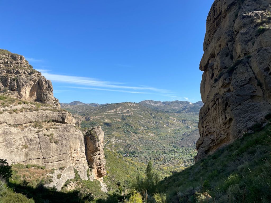
Quentareando

MTB
MTB
Ref..: 966622
Published: 01/06/2021
Performed: 29/05/2021
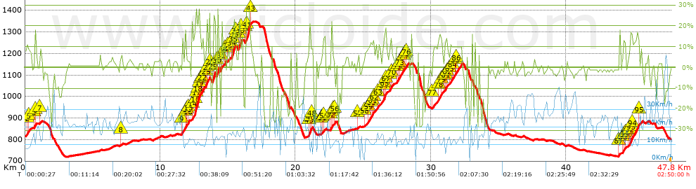
Distance in Km: 47.74
Climb in m: 1759
IBP: 156 BYC

Near ...
Barrio De La Vega, Barrio De Monachil, Cajar, Cenes De La Vega, Huetor Vega, Monachil
fernan2g
Author: fernan2g
1943 published routes

Add to my Group or Club

 Height in m      Climb in %      Speed in Km/h      Speed < 2 Km/h

Climbs > 5%

Climbs >5% Climbs >10% Climbs >15% Climbs >20% Climbs >25%
 Steep slope of 434 m.   Average slope  Distances  Download as waypoint
1
 Km 0  8%  133 m
2
 Km 0.133  11%  101 m
3
 Km 0.234  8%  200 m
 Steep slope of 168 m.  Average slope  Distances  Download as waypoint
4
 Km 0.679  7%  35 m
5
 Km 0.714  15%  99 m
6
 Km 0.813  9%  34 m
 Steep slope of 141 m.  Average slope  Distances  Download as waypoint
7
 Km 1.097  7%  141 m
 Steep slope of 119 m.  Average slope  Distances  Download as waypoint
8
 Km 7.077  6%  119 m
 Steep slope of 367 m.  Average slope  Distances  Download as waypoint
9
 Km 11.591  12%  296 m
10
 Km 11.887  9%  71 m
 Steep slope of 175 m.  Average slope  Distances  Download as waypoint
11
 Km 11.995  7%  66 m
12
 Km 12.062  13%  33 m
13
 Km 12.095  14%  76 m
 Steep slope of 806 m.  Average slope  Distances  Download as waypoint
14
 Km 12.348  13%  176 m
15
 Km 12.523  17%  36 m
16
 Km 12.559  28%  71 m
17
 Km 12.63  20%  106 m
18
 Km 12.736  25%  102 m
19
 Km 12.838  27%  76 m
20
 Km 12.915  14%  71 m
21
 Km 12.986  7%  101 m
22
 Km 13.087  14%  67 m
 Steep slope of 327 m.  Average slope  Distances  Download as waypoint
23
 Km 13.335  6%  34 m
24
 Km 13.369  12%  35 m
25
 Km 13.404  17%  112 m
26
 Km 13.516  11%  110 m
27
 Km 13.626  26%  36 m
 Steep slope of 211 m.  Average slope  Distances  Download as waypoint
28
 Km 13.875  11%  33 m
29
 Km 13.907  23%  178 m
 Steep slope of 146 m.  Average slope  Distances  Download as waypoint
30
 Km 14.201  28%  146 m
 Steep slope of 77 m.  Average slope  Distances  Download as waypoint
31
 Km 14.459  15%  77 m
 Steep slope of 113 m.  Average slope  Distances  Download as waypoint
32
 Km 14.719  17%  113 m
 Steep slope of 148 m.  Average slope  Distances  Download as waypoint
33
 Km 14.947  9%  148 m
 Steep slope of 285 m.  Average slope  Distances  Download as waypoint
34
 Km 15.273  17%  111 m
35
 Km 15.384  24%  139 m
36
 Km 15.522  15%  35 m
 Steep slope of 367 m.  Average slope  Distances  Download as waypoint
37
 Km 15.777  17%  113 m
38
 Km 15.89  25%  33 m
39
 Km 15.923  11%  221 m
 Steep slope of 474 m.  Average slope  Distances  Download as waypoint
40
 Km 16.316  19%  32 m
41
 Km 16.348  28%  295 m
42
 Km 16.642  14%  41 m
43
 Km 16.683  5%  106 m
 Steep slope of 317 m.  Average slope  Distances  Download as waypoint
44
 Km 20.919  6%  42 m
45
 Km 20.961  13%  64 m
46
 Km 21.026  19%  108 m
47
 Km 21.133  9%  34 m
48
 Km 21.167  8%  69 m
 Steep slope of 286 m.  Average slope  Distances  Download as waypoint
49
 Km 21.91  5%  79 m
50
 Km 21.989  11%  100 m
51
 Km 22.089  8%  107 m
 Steep slope of 178 m.  Average slope  Distances  Download as waypoint
52
 Km 22.583  18%  106 m
53
 Km 22.69  6%  72 m
 Steep slope of 173 m.  Average slope  Distances  Download as waypoint
54
 Km 22.797  11%  63 m
55
 Km 22.86  12%  36 m
56
 Km 22.896  10%  74 m
 Steep slope of 139 m.  Average slope  Distances  Download as waypoint
57
 Km 24.596  8%  139 m
 Steep slope of 838 m.  Average slope  Distances  Download as waypoint
58
 Km 25.088  7%  283 m
59
 Km 25.371  10%  165 m
60
 Km 25.535  9%  99 m
61
 Km 25.635  12%  150 m
62
 Km 25.785  8%  141 m
 Steep slope of 680 m.  Average slope  Distances  Download as waypoint
63
 Km 26.066  8%  414 m
64
 Km 26.48  14%  70 m
65
 Km 26.55  16%  99 m
66
 Km 26.65  19%  30 m
67
 Km 26.68  9%  67 m
 Steep slope of 318 m.  Average slope  Distances  Download as waypoint
68
 Km 26.928  8%  39 m
69
 Km 26.967  13%  137 m
70
 Km 27.103  8%  142 m
 Steep slope of 937 m.  Average slope  Distances  Download as waypoint
71
 Km 27.423  10%  131 m
72
 Km 27.554  10%  104 m
73
 Km 27.658  10%  315 m
74
 Km 27.973  10%  102 m
75
 Km 28.075  10%  113 m
76
 Km 28.188  9%  172 m
 Steep slope of 787 m.  Average slope  Distances  Download as waypoint
77
 Km 30.106  7%  443 m
78
 Km 30.549  13%  243 m
79
 Km 30.792  9%  101 m
 Steep slope of 1302 m.  Average slope  Distances  Download as waypoint
80
 Km 30.998  6%  38 m
81
 Km 31.036  13%  178 m
82
 Km 31.214  6%  176 m
83
 Km 31.389  10%  163 m
84
 Km 31.552  10%  178 m
85
 Km 31.73  10%  166 m
86
 Km 31.895  10%  403 m
 Steep slope of 139 m.  Average slope  Distances  Download as waypoint
87
 Km 43.875  11%  139 m
 Steep slope of 286 m.  Average slope  Distances  Download as waypoint
88
 Km 44.159  9%  80 m
89
 Km 44.239  10%  141 m
90
 Km 44.381  11%  65 m
 Steep slope of 1004 m.  Average slope  Distances  Download as waypoint
91
 Km 44.589  6%  107 m
92
 Km 44.696  11%  39 m
93
 Km 44.735  16%  113 m
94
 Km 44.847  13%  520 m
95
 Km 45.367  8%  225 m


Description of the route


Presence of ramps


 Climbs  Distance  % of the total  Speed  Your speed would be  Time  Your time would be
   15 - 30%  2.708  5.67  12.51  ?  0:12:59  ?
   10 - 15%  4.235  8.87  12.27  ?  0:20:43  ?
   5 - 10%  5.463  11.44  13.54  ?  0:24:13  ?
   1 - 5%  9.449  19.79  18.72  ?  0:30:17  ?
   Total*  21.855 Km  45.78 %  14.87 Km/h  ? Km/h    1:28:12 h  ? h  
 Flat
   1 - -1%  7.972 Km  16.7 %  19.76 Km/h  ? Km/h    0:24:12 h  ? h  
 Descents
   -1 - -5%  8.137  17.05  24.89  ?  0:19:37  ?
   -5 - -10%  3.052  6.39  19.8  ?  0:09:15  ?
   -10 - -15%  1.93  4.04  16.7  ?  0:06:56  ?
   -15 - -30%  4.849  10.16  13.35  ?  0:21:48  ?
   Total*  17.968 Km  37.64 %  18.72 Km/h  ? Km/h    0:57:36 h  ? h  
* The total has not necessarily coincide with the sum of the partials after correction of errors

How long would it take you?

How long would it take you to cover this route?
There are routes without a valid time information, but with your average stats you can assess the possible duration

fernan2g to cover this route you've need a time of:   2:50:00 h 
If you sign in and have a minimum of two tracks of this same modality, you can know your time for this route, calculated from your stats..


¿Cuanto consumirá tu E-BIKE?

Entra tu E-IBP (formato n,nn)

E-IBP :   X 156 = 


 Detected activity type =  ()
 Penalization due to track conditions: 75 %   ( > 50 % = MTB, < 50 % = RDB)
 Reliability of the track: B   (1799/65/0/-/-/65)
 Correction level applied to the track: 0
DIFFICULTY OF THE ROUTE
IBP = 156 BYC
According to your statistics
 Your time in motion would be: ? h
Your average speed would be: ? Km/h
 

 Total Distance: 47.74 Km
 Analysed distance: 47.74 Km
 Linear distance: 0.14 Km

 Cumulated positive ramps: 1759.34 m  list of points info
 Cumulated negative ramps: 1764.84 m
 Maximum height: 1348 m
 Minimum height: 720.1 m
 Climbing Ratio: 8.05 %
 Descent ratio: 9.82 %
 Cumulated postive ramps per Km: 36.85 m
 Cumulated negative ramps per Km: 36.97 m

 Total time: 2:50:00 h
 Time in movement: 2:50:00 h
 According to your statistics
 Your time in motion would be: ? h  
 Stopped time: 0:00:00 h
 Maximum slope filter: ~30 %
 Minimum separation analysed: ~30 m
 Number of points: 3777   (cad. 12.64 m)
 Significant waypoints: 1332   (cad. 35.87 m / 35.27 %)

 Changes in direction per Km: 12.82
 Changes in direction > 5º por Km: 9.26
 Cumulated straight stretches: 7.77 Km
 Straight stretches per Km: 162.76 m
 Penalized slope changes: 15
 Penalized slope changes per Km: 0.314

 Average speed in total: 16.85 Km/h
 Average speed while moving: 16.85 Km/h
 According to your statistics
 Your average speed would be: ? Km/h  
 Maximum sustained speed: 63.29 Km/h


Comments

You can be the first one in commenting this route

 
My comments
:
Add comment  (Registered users)
 
Notify me answers to my comment  Do not notify answers to my comment


Share this route with a friend

Your friend will receive a message with a link to this page:
will see your email and your user name if you do it as registered user.


Write here your name (optional)

E-mail address of your friend(s). You can include various addresses separated by commas

Text or comment (optional) maximum 255 characters long, 255 Available characters

As a non registered users you need to fill-in the captcha text.
  Change image
Type the image characters.
 
 Share with a friend


Visited history

Delete history

Marked routes for review later or compare

My favorites


  Notify anomaly in this route Share in Facebook