Sant Ramoneando

Road
Road
Ref..: 965169
Published: 28/05/2021
Performed: 27/05/2021
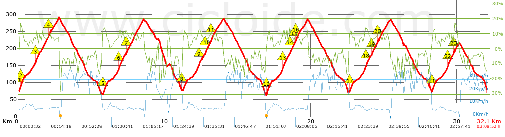
Distance in Km: 32.1
Climb in m: 1263
IBP: 83 BYC

Near ...
Sant Boi De Llobregat, Sant Climent De Llobregat, Santa Coloma De Cervello
Antonio_Sánchez
179 published routes

Add to my Group or Club

 Height in m      Climb in %      Speed in Km/h      Speed < 2 Km/h

Climbs > 5%

Climbs >5% Climbs >10% Climbs >15% Climbs >20% Climbs >25%
 Steep slope of 440 m.   Average slope  Distances  Download as waypoint
1
 Km 0.1  16%  101 m
2
 Km 0.201  12%  168 m
3
 Km 0.369  5%  171 m
 Steep slope of 708 m.  Average slope  Distances  Download as waypoint
4
 Km 0.777  7%  405 m
5
 Km 1.181  10%  200 m
6
 Km 1.381  10%  103 m
 Steep slope of 1191 m.  Average slope  Distances  Download as waypoint
7
 Km 1.587  9%  507 m
8
 Km 2.094  11%  99 m
9
 Km 2.193  7%  585 m
 Steep slope of 408 m.  Average slope  Distances  Download as waypoint
10
 Km 5.74  12%  240 m
11
 Km 5.981  8%  168 m
 Steep slope of 737 m.  Average slope  Distances  Download as waypoint
12
 Km 6.498  7%  373 m
13
 Km 6.871  12%  163 m
14
 Km 7.034  8%  201 m
 Steep slope of 1240 m.  Average slope  Distances  Download as waypoint
15
 Km 7.335  12%  105 m
16
 Km 7.44  8%  175 m
17
 Km 7.615  9%  240 m
18
 Km 7.856  8%  720 m
 Steep slope of 109 m.  Average slope  Distances  Download as waypoint
19
 Km 10.2  7%  109 m
 Steep slope of 370 m.  Average slope  Distances  Download as waypoint
20
 Km 11.205  11%  199 m
21
 Km 11.403  8%  171 m
 Steep slope of 1623 m.  Average slope  Distances  Download as waypoint
22
 Km 11.92  7%  409 m
23
 Km 12.329  13%  132 m
24
 Km 12.461  7%  306 m
25
 Km 12.767  11%  101 m
26
 Km 12.869  8%  268 m
27
 Km 13.137  10%  170 m
28
 Km 13.307  8%  237 m
 Steep slope of 370 m.  Average slope  Distances  Download as waypoint
29
 Km 13.648  8%  370 m
 Steep slope of 427 m.  Average slope  Distances  Download as waypoint
30
 Km 16.951  11%  164 m
31
 Km 17.115  9%  263 m
 Steep slope of 706 m.  Average slope  Distances  Download as waypoint
32
 Km 17.691  7%  410 m
33
 Km 18.101  10%  199 m
34
 Km 18.299  11%  97 m
 Steep slope of 1223 m.  Average slope  Distances  Download as waypoint
35
 Km 18.499  6%  34 m
36
 Km 18.533  12%  97 m
37
 Km 18.631  9%  174 m
38
 Km 18.805  8%  100 m
39
 Km 18.905  10%  102 m
40
 Km 19.006  12%  97 m
41
 Km 19.103  7%  619 m
 Steep slope of 330 m.  Average slope  Distances  Download as waypoint
42
 Km 22.619  10%  67 m
43
 Km 22.686  12%  132 m
44
 Km 22.817  7%  131 m
 Steep slope of 770 m.  Average slope  Distances  Download as waypoint
45
 Km 23.292  7%  441 m
46
 Km 23.733  11%  200 m
47
 Km 23.933  10%  129 m
 Steep slope of 1062 m.  Average slope  Distances  Download as waypoint
48
 Km 24.165  11%  100 m
49
 Km 24.265  8%  298 m
50
 Km 24.563  11%  100 m
51
 Km 24.663  8%  564 m
 Steep slope of 332 m.  Average slope  Distances  Download as waypoint
52
 Km 28.278  8%  36 m
53
 Km 28.314  13%  161 m
54
 Km 28.476  6%  135 m
 Steep slope of 525 m.  Average slope  Distances  Download as waypoint
55
 Km 28.947  7%  429 m
56
 Km 29.376  14%  96 m
 Steep slope of 574 m.  Average slope  Distances  Download as waypoint
57
 Km 29.505  7%  64 m
58
 Km 29.57  8%  234 m
59
 Km 29.804  12%  108 m
60
 Km 29.911  9%  168 m


Description of the route


Presence of ramps


 Climbs  Distance  % of the total  Speed  Your speed would be  Time  Your time would be
   15 - 30%  0.309  0.96  6.74  ?  0:02:45  ?
   10 - 15%  3.803  11.85  7.52  ?  0:30:20  ?
   5 - 10%  9.165  28.55  8.67  ?  1:03:26  ?
   1 - 5%  2.732  8.51  10.11  ?  0:16:13  ?
   Total*  16.009 Km  49.88 %  8.52 Km/h  ? Km/h    1:52:44 h  ? h  
 Flat
   1 - -1%  0.515 Km  1.6 %  11.74 Km/h  ? Km/h    0:02:38 h  ? h  
 Descents
   -1 - -5%  4.952  15.43  27.18  ?  0:10:56  ?
   -5 - -10%  5.854  18.24  29.19  ?  0:12:02  ?
   -10 - -15%  2.81  8.75  26.41  ?  0:06:23  ?
   -15 - -30%  1.958  6.1  22.74  ?  0:05:10  ?
   Total*  15.573 Km  48.52 %  27.07 Km/h  ? Km/h    0:34:31 h  ? h  
* The total has not necessarily coincide with the sum of the partials after correction of errors

How long would it take you?

How long would it take you to cover this route?
There are routes without a valid time information, but with your average stats you can assess the possible duration

Antonio_Sánchez to cover this route you've need a time of:   2:29:53 h 
If you sign in and have a minimum of two tracks of this same modality, you can know your time for this route, calculated from your stats..


¿Cuanto consumirá tu E-BIKE?

Entra tu E-IBP (formato n,nn)

E-IBP :   X 83 = 


 Detected activity type =  ()
 Penalization due to track conditions: 40 %   ( > 50 % = MTB, < 50 % = RDB)
 Reliability of the track: A   (1267/100/0/-/-/100)
 Correction level applied to the track: 0
DIFFICULTY OF THE ROUTE
IBP = 83 BYC
According to your statistics
 Your time in motion would be: ? h
Your average speed would be: ? Km/h
 

 Total Distance: 32.1 Km
 Analysed distance: 32.1 Km
 Linear distance: 0.01 Km

 Cumulated positive ramps: 1263.4 m  list of points info
 Cumulated negative ramps: 1267.53 m
 Maximum height: 297.2 m
 Minimum height: 60.6 m
 Climbing Ratio: 7.89 %
 Descent ratio: 8.14 %
 Cumulated postive ramps per Km: 39.36 m
 Cumulated negative ramps per Km: 39.49 m

 Total time: 3:08:52 h
 Time in movement: 2:29:53 h
 According to your statistics
 Your time in motion would be: ? h  
 Stopped time: 0:38:59 h
 Maximum slope filter: ~30 %
 Minimum separation analysed: ~30 m
 Number of points: 2579   (cad. 12.45 m)
 Significant waypoints: 928   (cad. 34.59 m / 35.98 %)

 Changes in direction per Km: 13.33
 Changes in direction > 5º por Km: 10.78
 Cumulated straight stretches: 3.256 Km
 Straight stretches per Km: 101.43 m
 Penalized slope changes: 11
 Penalized slope changes per Km: 0.343

 Average speed in total: 10.2 Km/h
 Average speed while moving: 12.85 Km/h
 According to your statistics
 Your average speed would be: ? Km/h  
 Maximum sustained speed: 42.93 Km/h


Comments

You can be the first one in commenting this route

 
My comments
:
Add comment  (Registered users)
 
Notify me answers to my comment  Do not notify answers to my comment


Share this route with a friend

Your friend will receive a message with a link to this page:
will see your email and your user name if you do it as registered user.


Write here your name (optional)

E-mail address of your friend(s). You can include various addresses separated by commas

Text or comment (optional) maximum 255 characters long, 255 Available characters

As a non registered users you need to fill-in the captcha text.
  Change image
Type the image characters.
 
 Share with a friend


Visited history

Delete history

Marked routes for review later or compare

My favorites


  Notify anomaly in this route Share in Facebook