2021 05 06 mansosniguelasrinconadaniguelas

Road
Road
Ref..: 959199
Published: 07/05/2021
Performed: 06/05/2021
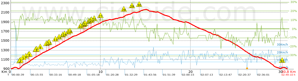
Distance in Km: 30.85
Climb in m: 1353
IBP: 106 BYC


 Height in m      Climb in %      Speed in Km/h      Speed < 2 Km/h

Climbs > 5%

Climbs >5% Climbs >10% Climbs >15% Climbs >20% Climbs >25%
 Steep slope of 335 m.   Average slope  Distances  Download as waypoint
1
 Km 0.03  8%  335 m
 Steep slope of 5275 m.  Average slope  Distances  Download as waypoint
2
 Km 0.884  10%  35 m
3
 Km 0.919  13%  166 m
4
 Km 1.085  17%  264 m
5
 Km 1.348  14%  129 m
6
 Km 1.477  8%  169 m
7
 Km 1.646  12%  304 m
8
 Km 1.95  10%  100 m
9
 Km 2.05  13%  716 m
10
 Km 2.766  11%  101 m
11
 Km 2.866  12%  224 m
12
 Km 3.09  9%  159 m
13
 Km 3.249  13%  299 m
14
 Km 3.549  8%  265 m
15
 Km 3.813  9%  101 m
16
 Km 3.914  9%  100 m
17
 Km 4.014  10%  167 m
18
 Km 4.181  10%  136 m
19
 Km 4.317  12%  404 m
20
 Km 4.721  8%  232 m
21
 Km 4.953  12%  201 m
22
 Km 5.154  8%  206 m
23
 Km 5.36  12%  433 m
24
 Km 5.793  10%  198 m
25
 Km 5.991  12%  134 m
26
 Km 6.126  10%  32 m
 Steep slope of 823 m.  Average slope  Distances  Download as waypoint
27
 Km 6.257  7%  98 m
28
 Km 6.355  14%  100 m
29
 Km 6.455  9%  127 m
30
 Km 6.583  12%  263 m
31
 Km 6.845  8%  235 m
 Steep slope of 3279 m.  Average slope  Distances  Download as waypoint
32
 Km 7.251  9%  469 m
33
 Km 7.72  11%  133 m
34
 Km 7.853  7%  199 m
35
 Km 8.053  11%  144 m
36
 Km 8.197  11%  101 m
37
 Km 8.298  12%  307 m
38
 Km 8.605  9%  100 m
39
 Km 8.705  11%  200 m
40
 Km 8.905  12%  105 m
41
 Km 9.01  10%  136 m
42
 Km 9.146  9%  97 m
43
 Km 9.243  8%  34 m
44
 Km 9.277  12%  103 m
45
 Km 9.38  8%  602 m
46
 Km 9.982  13%  230 m
47
 Km 10.212  6%  136 m
48
 Km 10.347  5%  183 m
 Steep slope of 276 m.  Average slope  Distances  Download as waypoint
49
 Km 10.666  7%  276 m
 Steep slope of 136 m.  Average slope  Distances  Download as waypoint
50
 Km 11.303  7%  136 m
 Steep slope of 170 m.  Average slope  Distances  Download as waypoint
51
 Km 11.542  6%  170 m
 Steep slope of 218 m.  Average slope  Distances  Download as waypoint
52
 Km 11.889  7%  218 m
 Steep slope of 588 m.  Average slope  Distances  Download as waypoint
53
 Km 12.434  8%  107 m
54
 Km 12.541  12%  240 m
55
 Km 12.782  8%  241 m
 Steep slope of 456 m.  Average slope  Distances  Download as waypoint
56
 Km 13.23  8%  216 m
57
 Km 13.446  12%  166 m
58
 Km 13.612  9%  74 m
 Steep slope of 653 m.  Average slope  Distances  Download as waypoint
59
 Km 14.045  6%  242 m
60
 Km 14.287  12%  173 m
61
 Km 14.46  7%  238 m
 Steep slope of 208 m.  Average slope  Distances  Download as waypoint
62
 Km 30.016  9%  104 m
63
 Km 30.12  14%  104 m


Description of the route


Presence of ramps


 Climbs  Distance  % of the total  Speed  Your speed would be  Time  Your time would be
   15 - 30%  0.816  2.64  6.89  ?  0:07:06  ?
   10 - 15%  5.213  16.9  7.66  ?  0:40:50  ?
   5 - 10%  6.405  20.76  8.98  ?  0:42:47  ?
   1 - 5%  2.446  7.93  11.05  ?  0:13:17  ?
   Total*  14.88 Km  48.24 %  8.58 Km/h  ? Km/h    1:44:00 h  ? h  
 Flat
   1 - -1%  0.847 Km  2.75 %  12.05 Km/h  ? Km/h    0:04:13 h  ? h  
 Descents
   -1 - -5%  2.697  8.74  17.75  ?  0:09:07  ?
   -5 - -10%  6.015  19.5  17.96  ?  0:20:06  ?
   -10 - -15%  5.388  17.46  17.1  ?  0:18:54  ?
   -15 - -30%  1.022  3.31  13.24  ?  0:04:38  ?
   Total*  15.122 Km  49.02 %  17.2 Km/h  ? Km/h    0:52:45 h  ? h  
* The total has not necessarily coincide with the sum of the partials after correction of errors

How long would it take you?

How long would it take you to cover this route?
There are routes without a valid time information, but with your average stats you can assess the possible duration

Armando_Rodriguez_Nieto to cover this route you've need a time of:   2:40:58 h 
If you sign in and have a minimum of two tracks of this same modality, you can know your time for this route, calculated from your stats..


¿Cuanto consumirá tu E-BIKE?

Entra tu E-IBP (formato n,nn)

E-IBP :   X 106 = 


 Detected activity type =  ()
 Penalization due to track conditions: 42 %   ( > 50 % = MTB, < 50 % = RDB)
 Reliability of the track: A   (1353/97/0/-/-/97)
 Correction level applied to the track: 0
DIFFICULTY OF THE ROUTE
IBP = 106 BYC
According to your statistics
 Your time in motion would be: ? h
Your average speed would be: ? Km/h
 

 Total Distance: 30.85 Km
 Analysed distance: 30.85 Km
 Linear distance: 0.01 Km

 Cumulated positive ramps: 1352.9 m  list of points info
 Cumulated negative ramps: 1351.8 m
 Maximum height: 2164.4 m
 Minimum height: 902.6 m
 Climbing Ratio: 9.09 %
 Descent ratio: 8.94 %
 Cumulated postive ramps per Km: 43.85 m
 Cumulated negative ramps per Km: 43.82 m

 Total time: 2:49:10 h
 Time in movement: 2:40:58 h
 According to your statistics
 Your time in motion would be: ? h  
 Stopped time: 0:08:12 h
 Maximum slope filter: ~30 %
 Minimum separation analysed: ~30 m
 Number of points: 2603   (cad. 11.85 m)
 Significant waypoints: 878   (cad. 35.13 m / 33.73 %)

 Changes in direction per Km: 12.03
 Changes in direction > 5º por Km: 10.15
 Cumulated straight stretches: 2.851 Km
 Straight stretches per Km: 92.41 m
 Penalized slope changes: 5
 Penalized slope changes per Km: 0.162

 Average speed in total: 10.94 Km/h
 Average speed while moving: 11.5 Km/h
 According to your statistics
 Your average speed would be: ? Km/h  
 Maximum sustained speed: 30.18 Km/h


Comments

You can be the first one in commenting this route

 
My comments
:
Add comment  (Registered users)
 
Notify me answers to my comment  Do not notify answers to my comment


Share this route with a friend

Your friend will receive a message with a link to this page:
will see your email and your user name if you do it as registered user.


Write here your name (optional)

E-mail address of your friend(s). You can include various addresses separated by commas

Text or comment (optional) maximum 255 characters long, 255 Available characters

As a non registered users you need to fill-in the captcha text.
  Change image
Type the image characters.
 
 Share with a friend


Visited history

Delete history

Marked routes for review later or compare

My favorites


  Notify anomaly in this route Share in Facebook