Probando la Specialized Turbo Creo SL

Road
Road
Ref..: 958552
Published: 04/05/2021
Performed: 01/05/2021
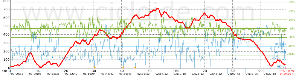
Distance in Km: 99.06
Climb in m: 1882
IBP: 118 BYC

Near ...
Agudelo (San Martiño ), Areas (Mourente), Areas (Parroquia Mourente), Armenteira (Santa Maria), Barcia, A (Marcon), Barro (San Breixo)

 Height in m      Climb in %      Speed in Km/h      Speed < 2 Km/h

Climbs > 5%

Climbs >5% Climbs >10% Climbs >15% Climbs >20% Climbs >25%
 Steep slope of 152 m.   Average slope  Distances  Download as waypoint
1
 Km 3.241  6%  152 m
 Steep slope of 518 m.  Average slope  Distances  Download as waypoint
2
 Km 5.399  7%  78 m
3
 Km 5.478  12%  123 m
4
 Km 5.6  8%  149 m
5
 Km 5.749  12%  107 m
6
 Km 5.856  9%  61 m
 Steep slope of 398 m.  Average slope  Distances  Download as waypoint
7
 Km 6.113  8%  398 m
 Steep slope of 125 m.  Average slope  Distances  Download as waypoint
8
 Km 11.138  7%  125 m
 Steep slope of 252 m.  Average slope  Distances  Download as waypoint
9
 Km 12.957  6%  252 m
 Steep slope of 433 m.  Average slope  Distances  Download as waypoint
10
 Km 17.804  6%  433 m
 Steep slope of 161 m.  Average slope  Distances  Download as waypoint
11
 Km 18.83  5%  161 m
 Steep slope of 633 m.  Average slope  Distances  Download as waypoint
12
 Km 19.296  6%  633 m
 Steep slope of 139 m.  Average slope  Distances  Download as waypoint
13
 Km 20.181  5%  139 m
 Steep slope of 797 m.  Average slope  Distances  Download as waypoint
14
 Km 20.699  7%  797 m
 Steep slope of 273 m.  Average slope  Distances  Download as waypoint
15
 Km 22.403  6%  273 m
 Steep slope of 380 m.  Average slope  Distances  Download as waypoint
16
 Km 22.967  8%  380 m
 Steep slope of 311 m.  Average slope  Distances  Download as waypoint
17
 Km 25.122  7%  311 m
 Steep slope of 201 m.  Average slope  Distances  Download as waypoint
18
 Km 25.541  7%  201 m
 Steep slope of 143 m.  Average slope  Distances  Download as waypoint
19
 Km 26.694  8%  143 m
 Steep slope of 537 m.  Average slope  Distances  Download as waypoint
20
 Km 28.313  9%  128 m
21
 Km 28.441  11%  148 m
22
 Km 28.589  6%  261 m
 Steep slope of 326 m.  Average slope  Distances  Download as waypoint
23
 Km 29.363  12%  111 m
24
 Km 29.474  5%  215 m
 Steep slope of 261 m.  Average slope  Distances  Download as waypoint
25
 Km 29.904  8%  261 m
 Steep slope of 985 m.  Average slope  Distances  Download as waypoint
26
 Km 31.098  7%  985 m
 Steep slope of 180 m.  Average slope  Distances  Download as waypoint
27
 Km 38.497  7%  180 m
 Steep slope of 186 m.  Average slope  Distances  Download as waypoint
28
 Km 39.021  5%  186 m
 Steep slope of 594 m.  Average slope  Distances  Download as waypoint
29
 Km 39.459  8%  594 m
 Steep slope of 719 m.  Average slope  Distances  Download as waypoint
30
 Km 40.397  8%  719 m
 Steep slope of 187 m.  Average slope  Distances  Download as waypoint
31
 Km 41.426  6%  187 m
 Steep slope of 144 m.  Average slope  Distances  Download as waypoint
32
 Km 41.714  7%  144 m
 Steep slope of 217 m.  Average slope  Distances  Download as waypoint
33
 Km 42.155  5%  217 m
 Steep slope of 781 m.  Average slope  Distances  Download as waypoint
34
 Km 43.297  7%  781 m
 Steep slope of 393 m.  Average slope  Distances  Download as waypoint
35
 Km 48.059  6%  393 m
 Steep slope of 184 m.  Average slope  Distances  Download as waypoint
36
 Km 49.735  5%  184 m
 Steep slope of 287 m.  Average slope  Distances  Download as waypoint
37
 Km 50.241  6%  287 m
 Steep slope of 206 m.  Average slope  Distances  Download as waypoint
38
 Km 50.968  5%  206 m
 Steep slope of 221 m.  Average slope  Distances  Download as waypoint
39
 Km 54.321  11%  99 m
40
 Km 54.42  6%  122 m
 Steep slope of 212 m.  Average slope  Distances  Download as waypoint
41
 Km 54.802  5%  212 m
 Steep slope of 105 m.  Average slope  Distances  Download as waypoint
42
 Km 55.123  7%  105 m
 Steep slope of 135 m.  Average slope  Distances  Download as waypoint
43
 Km 59.485  5%  135 m
 Steep slope of 169 m.  Average slope  Distances  Download as waypoint
44
 Km 63.393  6%  169 m
 Steep slope of 247 m.  Average slope  Distances  Download as waypoint
45
 Km 64.467  6%  247 m
 Steep slope of 252 m.  Average slope  Distances  Download as waypoint
46
 Km 64.978  8%  252 m
 Steep slope of 325 m.  Average slope  Distances  Download as waypoint
47
 Km 65.43  11%  182 m
48
 Km 65.612  9%  143 m
 Steep slope of 202 m.  Average slope  Distances  Download as waypoint
49
 Km 68.03  7%  202 m
 Steep slope of 288 m.  Average slope  Distances  Download as waypoint
50
 Km 68.343  7%  288 m
 Steep slope of 252 m.  Average slope  Distances  Download as waypoint
51
 Km 69.128  5%  252 m
 Steep slope of 148 m.  Average slope  Distances  Download as waypoint
52
 Km 69.556  9%  148 m
 Steep slope of 105 m.  Average slope  Distances  Download as waypoint
53
 Km 71.586  8%  105 m
 Steep slope of 139 m.  Average slope  Distances  Download as waypoint
54
 Km 72.004  8%  139 m
 Steep slope of 123 m.  Average slope  Distances  Download as waypoint
55
 Km 74.236  7%  123 m
 Steep slope of 150 m.  Average slope  Distances  Download as waypoint
56
 Km 75.072  6%  150 m
 Steep slope of 157 m.  Average slope  Distances  Download as waypoint
57
 Km 80.865  7%  157 m
 Steep slope of 117 m.  Average slope  Distances  Download as waypoint
58
 Km 94.233  6%  117 m
 Steep slope of 153 m.  Average slope  Distances  Download as waypoint
59
 Km 94.699  6%  153 m
 Steep slope of 237 m.  Average slope  Distances  Download as waypoint
60
 Km 95.786  5%  237 m


Description of the route


Presence of ramps


 Climbs  Distance  % of the total  Speed  Your speed would be  Time  Your time would be
   15 - 30%  0.066  0.07  11.35  ?  0:00:21  ?
   10 - 15%  1.8  1.82  11.31  ?  0:09:33  ?
   5 - 10%  14.858  15  13.84  ?  1:04:25  ?
   1 - 5%  21.422  21.63  18.09  ?  1:11:04  ?
   Total*  38.146 Km  38.51 %  15.74 Km/h  ? Km/h    2:25:23 h  ? h  
 Flat
   1 - -1%  17.242 Km  17.4 %  25.62 Km/h  ? Km/h    0:40:23 h  ? h  
 Descents
   -1 - -5%  29.299  29.58  34.53  ?  0:50:55  ?
   -5 - -10%  13.121  13.24  40.13  ?  0:19:37  ?
   -10 - -15%  1.1  1.11  29.12  ?  0:02:16  ?
   -15 - -30%  0.154  0.16  26.45  ?  0:00:21  ?
   Total*  43.674 Km  44.09 %  35.82 Km/h  ? Km/h    1:13:09 h  ? h  
* The total has not necessarily coincide with the sum of the partials after correction of errors

How long would it take you?

How long would it take you to cover this route?
There are routes without a valid time information, but with your average stats you can assess the possible duration

Ramón Mella to cover this route you've need a time of:   4:18:55 h 
If you sign in and have a minimum of two tracks of this same modality, you can know your time for this route, calculated from your stats..


¿Cuanto consumirá tu E-BIKE?

Entra tu E-IBP (formato n,nn)

E-IBP :   X 118 = 


 Detected activity type =  ()
 Penalization due to track conditions: 46 %   ( > 50 % = MTB, < 50 % = RDB)
 Reliability of the track: A   (1882/76/0/-/-/76)
 Correction level applied to the track: 0
DIFFICULTY OF THE ROUTE
IBP = 118 BYC
According to your statistics
 Your time in motion would be: ? h
Your average speed would be: ? Km/h
 

 Total Distance: 99.06 Km
 Analysed distance: 99.06 Km
 Linear distance: 0.95 Km

 Cumulated positive ramps: 1882.4 m  list of points info
 Cumulated negative ramps: 1848 m
 Maximum height: 712.2 m
 Minimum height: 3.2 m
 Climbing Ratio: 4.93 %
 Descent ratio: 4.23 %
 Cumulated postive ramps per Km: 19 m
 Cumulated negative ramps per Km: 18.66 m

 Total time: 4:39:06 h
 Time in movement: 4:18:55 h
 According to your statistics
 Your time in motion would be: ? h  
 Stopped time: 0:20:11 h
 Maximum slope filter: ~30 %
 Minimum separation analysed: ~30 m
 Number of points: 4805   (cad. 20.62 m)
 Significant waypoints: 2392   (cad. 41.41 m / 49.78 %)

 Changes in direction per Km: 7.66
 Changes in direction > 5º por Km: 5.31
 Cumulated straight stretches: 23.214 Km
 Straight stretches per Km: 234.34 m
 Penalized slope changes: 21
 Penalized slope changes per Km: 0.212

 Average speed in total: 21.3 Km/h
 Average speed while moving: 22.96 Km/h
 According to your statistics
 Your average speed would be: ? Km/h  
 Maximum sustained speed: 65.71 Km/h


Comments

You can be the first one in commenting this route

 
My comments
:
Add comment  (Registered users)
 
Notify me answers to my comment  Do not notify answers to my comment


Share this route with a friend

Your friend will receive a message with a link to this page:
will see your email and your user name if you do it as registered user.


Write here your name (optional)

E-mail address of your friend(s). You can include various addresses separated by commas

Text or comment (optional) maximum 255 characters long, 255 Available characters

As a non registered users you need to fill-in the captcha text.
  Change image
Type the image characters.
 
 Share with a friend


Visited history

Delete history

Marked routes for review later or compare

My favorites


  Notify anomaly in this route Share in Facebook