Pla de la calma / figaro / castellar

MTB
MTB
Ref..: 955218
Published: 20/04/2021
Performed: 19/04/2021
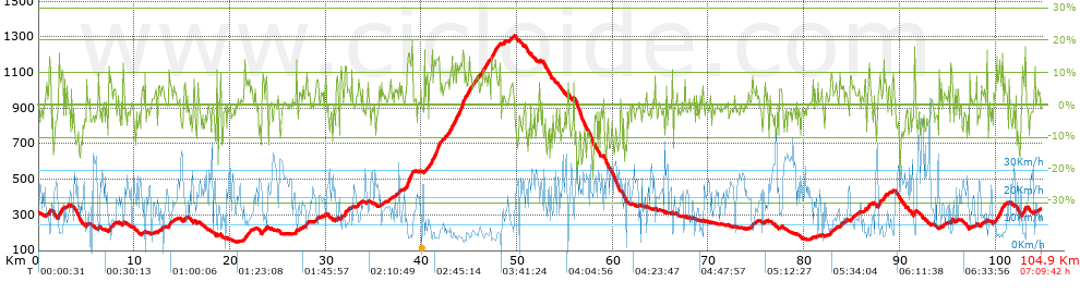
Distance in Km: 104.9
Climb in m: 2588
IBP: 191 BYC

Near ...
Badia Del Valles, Can Carner (Residencial), Castellar Del Valles, Pla De La Bruguera, Sant Feliu Del Raco
Pepito_Palotes
460 published routes

Add to my Group or Club

 Height in m      Climb in %      Speed in Km/h      Speed < 2 Km/h

Climbs > 5%

Climbs >5% Climbs >10% Climbs >15% Climbs >20% Climbs >25%
 Steep slope of 196 m.   Average slope  Distances  Download as waypoint
1
 Km 1.061  8%  75 m
2
 Km 1.136  13%  121 m
 Steep slope of 493 m.  Average slope  Distances  Download as waypoint
3
 Km 2.057  14%  106 m
4
 Km 2.164  9%  200 m
5
 Km 2.364  12%  125 m
6
 Km 2.489  9%  62 m
 Steep slope of 136 m.  Average slope  Distances  Download as waypoint
7
 Km 2.932  6%  136 m
 Steep slope of 131 m.  Average slope  Distances  Download as waypoint
8
 Km 4.986  6%  131 m
 Steep slope of 143 m.  Average slope  Distances  Download as waypoint
9
 Km 6.23  8%  143 m
 Steep slope of 506 m.  Average slope  Distances  Download as waypoint
10
 Km 7.327  7%  506 m
 Steep slope of 145 m.  Average slope  Distances  Download as waypoint
11
 Km 8.818  10%  145 m
 Steep slope of 151 m.  Average slope  Distances  Download as waypoint
12
 Km 12.514  7%  151 m
 Steep slope of 188 m.  Average slope  Distances  Download as waypoint
13
 Km 12.852  6%  188 m
 Steep slope of 260 m.  Average slope  Distances  Download as waypoint
14
 Km 13.61  9%  260 m
 Steep slope of 248 m.  Average slope  Distances  Download as waypoint
15
 Km 15.154  7%  248 m
 Steep slope of 129 m.  Average slope  Distances  Download as waypoint
16
 Km 16.216  8%  129 m
 Steep slope of 587 m.  Average slope  Distances  Download as waypoint
17
 Km 21.481  8%  587 m
 Steep slope of 418 m.  Average slope  Distances  Download as waypoint
18
 Km 23.401  7%  418 m
 Steep slope of 152 m.  Average slope  Distances  Download as waypoint
19
 Km 26.871  8%  38 m
20
 Km 26.909  14%  114 m
 Steep slope of 214 m.  Average slope  Distances  Download as waypoint
21
 Km 27.897  9%  214 m
 Steep slope of 259 m.  Average slope  Distances  Download as waypoint
22
 Km 29.034  8%  259 m
 Steep slope of 147 m.  Average slope  Distances  Download as waypoint
23
 Km 29.915  8%  147 m
 Steep slope of 126 m.  Average slope  Distances  Download as waypoint
24
 Km 31.127  10%  126 m
 Steep slope of 211 m.  Average slope  Distances  Download as waypoint
25
 Km 31.544  7%  39 m
26
 Km 31.583  13%  111 m
27
 Km 31.694  7%  61 m
 Steep slope of 216 m.  Average slope  Distances  Download as waypoint
28
 Km 31.967  7%  68 m
29
 Km 32.035  12%  148 m
 Steep slope of 149 m.  Average slope  Distances  Download as waypoint
30
 Km 32.296  5%  149 m
 Steep slope of 92 m.  Average slope  Distances  Download as waypoint
31
 Km 32.693  9%  92 m
 Steep slope of 232 m.  Average slope  Distances  Download as waypoint
32
 Km 33.291  7%  232 m
 Steep slope of 166 m.  Average slope  Distances  Download as waypoint
33
 Km 36.699  6%  166 m
 Steep slope of 204 m.  Average slope  Distances  Download as waypoint
34
 Km 37.237  6%  204 m
 Steep slope of 225 m.  Average slope  Distances  Download as waypoint
35
 Km 37.565  6%  225 m
 Steep slope of 606 m.  Average slope  Distances  Download as waypoint
36
 Km 38.501  13%  65 m
37
 Km 38.566  15%  156 m
38
 Km 38.722  13%  343 m
39
 Km 39.065  14%  42 m
 Steep slope of 154 m.  Average slope  Distances  Download as waypoint
40
 Km 40.338  8%  154 m
 Steep slope of 103 m.  Average slope  Distances  Download as waypoint
41
 Km 40.603  12%  103 m
 Steep slope of 1122 m.  Average slope  Distances  Download as waypoint
42
 Km 40.995  8%  43 m
43
 Km 41.038  12%  146 m
44
 Km 41.184  9%  103 m
45
 Km 41.288  13%  466 m
46
 Km 41.754  17%  104 m
47
 Km 41.858  16%  30 m
48
 Km 41.888  6%  230 m
 Steep slope of 225 m.  Average slope  Distances  Download as waypoint
49
 Km 42.28  5%  225 m
 Steep slope of 3269 m.  Average slope  Distances  Download as waypoint
50
 Km 42.649  8%  389 m
51
 Km 43.037  11%  186 m
52
 Km 43.223  9%  141 m
53
 Km 43.365  11%  198 m
54
 Km 43.562  9%  110 m
55
 Km 43.672  12%  153 m
56
 Km 43.826  10%  101 m
57
 Km 43.927  12%  370 m
58
 Km 44.297  17%  149 m
59
 Km 44.445  15%  35 m
60
 Km 44.48  12%  83 m
61
 Km 44.564  12%  125 m
62
 Km 44.689  9%  1229 m
 Steep slope of 1066 m.  Average slope  Distances  Download as waypoint
63
 Km 46.072  7%  354 m
64
 Km 46.426  11%  108 m
65
 Km 46.535  8%  604 m
 Steep slope of 845 m.  Average slope  Distances  Download as waypoint
66
 Km 47.265  9%  253 m
67
 Km 47.518  11%  312 m
68
 Km 47.83  7%  280 m
 Steep slope of 222 m.  Average slope  Distances  Download as waypoint
69
 Km 49.296  5%  222 m
 Steep slope of 112 m.  Average slope  Distances  Download as waypoint
70
 Km 55.863  12%  112 m
 Steep slope of 174 m.  Average slope  Distances  Download as waypoint
71
 Km 74.503  9%  174 m
 Steep slope of 97 m.  Average slope  Distances  Download as waypoint
72
 Km 75.908  7%  97 m
 Steep slope of 163 m.  Average slope  Distances  Download as waypoint
73
 Km 82.769  8%  163 m
 Steep slope of 240 m.  Average slope  Distances  Download as waypoint
74
 Km 83.91  5%  240 m
 Steep slope of 200 m.  Average slope  Distances  Download as waypoint
75
 Km 85.07  6%  200 m
 Steep slope of 251 m.  Average slope  Distances  Download as waypoint
76
 Km 86.327  5%  251 m
 Steep slope of 281 m.  Average slope  Distances  Download as waypoint
77
 Km 86.72  8%  281 m
 Steep slope of 324 m.  Average slope  Distances  Download as waypoint
78
 Km 87.751  11%  182 m
79
 Km 87.934  9%  142 m
 Steep slope of 227 m.  Average slope  Distances  Download as waypoint
80
 Km 88.324  13%  93 m
81
 Km 88.417  8%  134 m
 Steep slope of 160 m.  Average slope  Distances  Download as waypoint
82
 Km 88.764  5%  160 m
 Steep slope of 101 m.  Average slope  Distances  Download as waypoint
83
 Km 89.24  5%  101 m
 Steep slope of 241 m.  Average slope  Distances  Download as waypoint
84
 Km 91.505  12%  210 m
85
 Km 91.715  8%  31 m
 Steep slope of 217 m.  Average slope  Distances  Download as waypoint
86
 Km 94.134  6%  217 m
 Steep slope of 104 m.  Average slope  Distances  Download as waypoint
87
 Km 94.6  8%  104 m
 Steep slope of 193 m.  Average slope  Distances  Download as waypoint
88
 Km 95.336  11%  151 m
89
 Km 95.486  12%  42 m
 Steep slope of 182 m.  Average slope  Distances  Download as waypoint
90
 Km 97.878  6%  182 m
 Steep slope of 102 m.  Average slope  Distances  Download as waypoint
91
 Km 98.458  6%  102 m
 Steep slope of 811 m.  Average slope  Distances  Download as waypoint
92
 Km 99.967  6%  165 m
93
 Km 100.131  10%  112 m
94
 Km 100.243  9%  152 m
95
 Km 100.395  12%  211 m
96
 Km 100.606  9%  102 m
97
 Km 100.708  16%  69 m
 Steep slope of 106 m.  Average slope  Distances  Download as waypoint
98
 Km 100.925  9%  106 m
 Steep slope of 423 m.  Average slope  Distances  Download as waypoint
99
 Km 102.79  8%  283 m
100
 Km 103.073  15%  102 m
101
 Km 103.175  9%  38 m


Description of the route


Presence of ramps


 Climbs  Distance  % of the total  Speed  Your speed would be  Time  Your time would be
   15 - 30%  1.33  1.27  6.47  ?  0:12:20  ?
   10 - 15%  5.796  5.53  7.84  ?  0:44:22  ?
   5 - 10%  14.954  14.26  10.03  ?  1:29:30  ?
   1 - 5%  20.54  19.58  13.98  ?  1:28:11  ?
   Total*  42.62 Km  40.63 %  10.91 Km/h  ? Km/h    3:54:23 h  ? h  
 Flat
   1 - -1%  18.233 Km  17.38 %  19.9 Km/h  ? Km/h    0:54:58 h  ? h  
 Descents
   -1 - -5%  23.69  22.58  21.57  ?  1:05:54  ?
   -5 - -10%  13.088  12.48  23.62  ?  0:33:15  ?
   -10 - -15%  5.263  5.02  21.05  ?  0:15:00  ?
   -15 - -30%  2.004  1.91  20.67  ?  0:05:49  ?
   Total*  44.045 Km  41.99 %  22.03 Km/h  ? Km/h    1:59:58 h  ? h  
* The total has not necessarily coincide with the sum of the partials after correction of errors

How long would it take you?

How long would it take you to cover this route?
There are routes without a valid time information, but with your average stats you can assess the possible duration

Pepito_Palotes to cover this route you've need a time of:   6:49:19 h 
If you sign in and have a minimum of two tracks of this same modality, you can know your time for this route, calculated from your stats..


¿Cuanto consumirá tu E-BIKE?

Entra tu E-IBP (formato n,nn)

E-IBP :   X 191 = 


 Detected activity type =  ()
 Penalization due to track conditions: 73 %   ( > 50 % = MTB, < 50 % = RDB)
 Reliability of the track: B   (2588/68/0/-/-/68)
 Correction level applied to the track: 0
DIFFICULTY OF THE ROUTE
IBP = 191 BYC
According to your statistics
 Your time in motion would be: ? h
Your average speed would be: ? Km/h
 

 Total Distance: 104.9 Km
 Analysed distance: 104.9 Km
 Linear distance: 0.16 Km

 Cumulated positive ramps: 2588 m  list of points info
 Cumulated negative ramps: 2564.8 m
 Maximum height: 1305.6 m
 Minimum height: 148.2 m
 Climbing Ratio: 6.07 %
 Descent ratio: 5.82 %
 Cumulated postive ramps per Km: 24.67 m
 Cumulated negative ramps per Km: 24.45 m

 Total time: 7:09:42 h
 Time in movement: 6:49:19 h
 According to your statistics
 Your time in motion would be: ? h  
 Stopped time: 0:20:23 h
 Maximum slope filter: ~30 %
 Minimum separation analysed: ~30 m
 Number of points: 5665   (cad. 18.52 m)
 Significant waypoints: 2636   (cad. 39.79 m / 46.53 %)

 Changes in direction per Km: 10.25
 Changes in direction > 5º por Km: 7.14
 Cumulated straight stretches: 22.085 Km
 Straight stretches per Km: 210.53 m
 Penalized slope changes: 19
 Penalized slope changes per Km: 0.181

 Average speed in total: 14.65 Km/h
 Average speed while moving: 15.38 Km/h
 According to your statistics
 Your average speed would be: ? Km/h  
 Maximum sustained speed: 46.05 Km/h


Comments

You can be the first one in commenting this route

 
My comments
:
Add comment  (Registered users)
 
Notify me answers to my comment  Do not notify answers to my comment


Share this route with a friend

Your friend will receive a message with a link to this page:
will see your email and your user name if you do it as registered user.


Write here your name (optional)

E-mail address of your friend(s). You can include various addresses separated by commas

Text or comment (optional) maximum 255 characters long, 255 Available characters

As a non registered users you need to fill-in the captcha text.
  Change image
Type the image characters.
 
 Share with a friend


Visited history

Delete history

Marked routes for review later or compare

My favorites


  Notify anomaly in this route Share in Facebook