2021 03 30 mansospadreeternobudapunetepalo

MTB
MTB
Ref..: 949532
Published: 31/03/2021
Performed: 30/03/2021
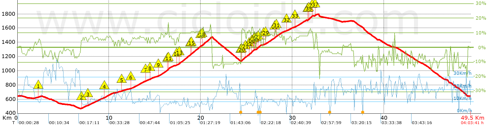
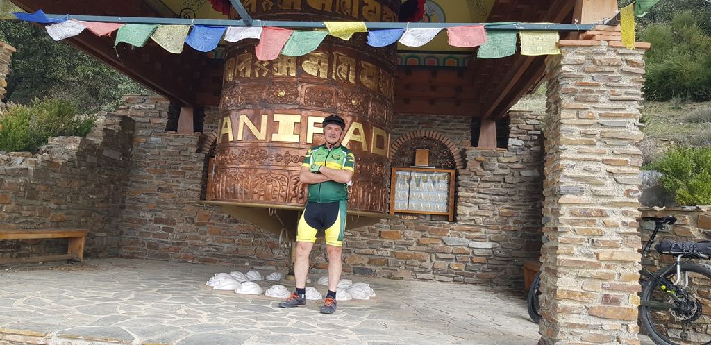
Distance in Km: 49.47
Climb in m: 1736
IBP: 123 BYC


 Height in m      Climb in %      Speed in Km/h      Speed < 2 Km/h

Climbs > 5%

Climbs >5% Climbs >10% Climbs >15% Climbs >20% Climbs >25%
 Steep slope of 139 m.   Average slope  Distances  Download as waypoint
1
 Km 2.28  6%  139 m
 Steep slope of 502 m.  Average slope  Distances  Download as waypoint
2
 Km 7.002  6%  502 m
 Steep slope of 1584 m.  Average slope  Distances  Download as waypoint
3
 Km 7.716  6%  1584 m
 Steep slope of 950 m.  Average slope  Distances  Download as waypoint
4
 Km 9.418  7%  950 m
 Steep slope of 106 m.  Average slope  Distances  Download as waypoint
5
 Km 11.322  7%  106 m
 Steep slope of 1400 m.  Average slope  Distances  Download as waypoint
6
 Km 12.404  7%  1400 m
 Steep slope of 351 m.  Average slope  Distances  Download as waypoint
7
 Km 13.974  6%  351 m
 Steep slope of 423 m.  Average slope  Distances  Download as waypoint
8
 Km 14.463  7%  423 m
 Steep slope of 1777 m.  Average slope  Distances  Download as waypoint
9
 Km 15.32  8%  1015 m
10
 Km 16.336  12%  138 m
11
 Km 16.473  8%  624 m
 Steep slope of 3860 m.  Average slope  Distances  Download as waypoint
12
 Km 17.334  7%  378 m
13
 Km 17.712  10%  1132 m
14
 Km 18.844  10%  100 m
15
 Km 18.944  11%  1062 m
16
 Km 20.006  6%  139 m
17
 Km 20.145  8%  35 m
18
 Km 20.18  12%  1014 m
 Steep slope of 1498 m.  Average slope  Distances  Download as waypoint
19
 Km 24.413  10%  35 m
20
 Km 24.448  12%  417 m
21
 Km 24.865  9%  354 m
22
 Km 25.22  12%  379 m
23
 Km 25.598  11%  133 m
24
 Km 25.732  11%  102 m
25
 Km 25.834  9%  78 m
 Steep slope of 522 m.  Average slope  Distances  Download as waypoint
26
 Km 26.023  9%  213 m
27
 Km 26.236  12%  309 m
 Steep slope of 101 m.  Average slope  Distances  Download as waypoint
28
 Km 26.823  6%  101 m
 Steep slope of 2024 m.  Average slope  Distances  Download as waypoint
29
 Km 27.098  9%  950 m
30
 Km 28.048  12%  173 m
31
 Km 28.221  8%  901 m
 Steep slope of 588 m.  Average slope  Distances  Download as waypoint
32
 Km 29.334  7%  588 m
 Steep slope of 1301 m.  Average slope  Distances  Download as waypoint
33
 Km 30.231  8%  1301 m
 Steep slope of 621 m.  Average slope  Distances  Download as waypoint
34
 Km 31.631  9%  100 m
35
 Km 31.731  12%  450 m
36
 Km 32.181  7%  71 m
 Steep slope of 214 m.  Average slope  Distances  Download as waypoint
37
 Km 32.464  9%  214 m


Description of the route


Presence of ramps


 Climbs  Distance  % of the total  Speed  Your speed would be  Time  Your time would be
   15 - 30%  0.203  0.41  9.15  ?  0:01:20  ?
   10 - 15%  5.286  10.69  8.9  ?  0:35:38  ?
   5 - 10%  12.635  25.54  11.41  ?  1:06:26  ?
   1 - 5%  6.213  12.56  14.14  ?  0:26:22  ?
   Total*  24.338 Km  49.2 %  11.25 Km/h  ? Km/h    2:09:46 h  ? h  
 Flat
   1 - -1%  2.204 Km  4.46 %  19.45 Km/h  ? Km/h    0:06:48 h  ? h  
 Descents
   -1 - -5%  7.867  15.9  22.11  ?  0:21:21  ?
   -5 - -10%  7.484  15.13  23.21  ?  0:19:21  ?
   -10 - -15%  6.892  13.93  17.34  ?  0:23:51  ?
   -15 - -30%  0.683  1.38  16.06  ?  0:02:33  ?
   Total*  22.925 Km  46.34 %  20.5 Km/h  ? Km/h    1:07:06 h  ? h  
* The total has not necessarily coincide with the sum of the partials after correction of errors

How long would it take you?

How long would it take you to cover this route?
There are routes without a valid time information, but with your average stats you can assess the possible duration

Armando_Rodriguez_Nieto to cover this route you've need a time of:   3:23:40 h 
If you sign in and have a minimum of two tracks of this same modality, you can know your time for this route, calculated from your stats..


¿Cuanto consumirá tu E-BIKE?

Entra tu E-IBP (formato n,nn)

E-IBP :   X 123 = 


 Detected activity type =  ()
 Penalization due to track conditions: 72 %   ( > 50 % = MTB, < 50 % = RDB)
 Reliability of the track: A   (1735/100/0/-/-/100)
 Correction level applied to the track: 0
DIFFICULTY OF THE ROUTE
IBP = 123 BYC
According to your statistics
 Your time in motion would be: ? h
Your average speed would be: ? Km/h
 

 Total Distance: 49.47 Km
 Analysed distance: 49.47 Km
 Linear distance: 0.01 Km

 Cumulated positive ramps: 1735.53 m  list of points info
 Cumulated negative ramps: 1733.83 m
 Maximum height: 1794.2 m
 Minimum height: 466 m
 Climbing Ratio: 7.13 %
 Descent ratio: 7.56 %
 Cumulated postive ramps per Km: 35.08 m
 Cumulated negative ramps per Km: 35.05 m

 Total time: 4:03:41 h
 Time in movement: 3:23:40 h
 According to your statistics
 Your time in motion would be: ? h  
 Stopped time: 0:40:01 h
 Maximum slope filter: ~30 %
 Minimum separation analysed: ~30 m
 Number of points: 3970   (cad. 12.46 m)
 Significant waypoints: 1403   (cad. 35.26 m / 35.34 %)

 Changes in direction per Km: 10.73
 Changes in direction > 5º por Km: 8.55
 Cumulated straight stretches: 7.277 Km
 Straight stretches per Km: 147.1 m
 Penalized slope changes: 7
 Penalized slope changes per Km: 0.142

 Average speed in total: 12.18 Km/h
 Average speed while moving: 14.57 Km/h
 According to your statistics
 Your average speed would be: ? Km/h  
 Maximum sustained speed: 45.81 Km/h


Comments

You can be the first one in commenting this route

 
My comments
:
Add comment  (Registered users)
 
Notify me answers to my comment  Do not notify answers to my comment


Share this route with a friend

Your friend will receive a message with a link to this page:
will see your email and your user name if you do it as registered user.


Write here your name (optional)

E-mail address of your friend(s). You can include various addresses separated by commas

Text or comment (optional) maximum 255 characters long, 255 Available characters

As a non registered users you need to fill-in the captcha text.
  Change image
Type the image characters.
 
 Share with a friend


Visited history

Delete history

Marked routes for review later or compare

My favorites


  Notify anomaly in this route Share in Facebook