Sabiñanigo (Huesca)

Road
Road
Ref..: 938050
Published: 18/02/2021
Performed: 17/02/2021
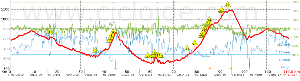
Distance in Km: 119.83
Climb in m: 1412
IBP: 102 BYC

Near ...
Aurin, Canfranc (Pueblo), Cartirana, Panticosa (Balneario), Panticosa (Pueblo), Puente De Sabiñanigo
Luis García Landa
714 published routes

Add to my Group or Club

 Height in m      Climb in %      Speed in Km/h      Speed < 2 Km/h

Climbs > 5%

Climbs >5% Climbs >10% Climbs >15% Climbs >20% Climbs >25%
 Steep slope of 226 m.   Average slope  Distances  Download as waypoint
1
 Km 16.653  6%  226 m
 Steep slope of 130 m.  Average slope  Distances  Download as waypoint
2
 Km 36.482  8%  130 m
 Steep slope of 282 m.  Average slope  Distances  Download as waypoint
3
 Km 42.424  6%  282 m
 Steep slope of 328 m.  Average slope  Distances  Download as waypoint
4
 Km 42.936  6%  328 m
 Steep slope of 237 m.  Average slope  Distances  Download as waypoint
5
 Km 43.365  6%  237 m
 Steep slope of 1021 m.  Average slope  Distances  Download as waypoint
6
 Km 43.936  7%  1021 m
 Steep slope of 94 m.  Average slope  Distances  Download as waypoint
7
 Km 58.88  6%  94 m
 Steep slope of 206 m.  Average slope  Distances  Download as waypoint
8
 Km 60.554  6%  206 m
 Steep slope of 428 m.  Average slope  Distances  Download as waypoint
9
 Km 61.327  6%  428 m
 Steep slope of 138 m.  Average slope  Distances  Download as waypoint
10
 Km 61.86  8%  138 m
 Steep slope of 147 m.  Average slope  Distances  Download as waypoint
11
 Km 63.483  11%  147 m
 Steep slope of 99 m.  Average slope  Distances  Download as waypoint
12
 Km 64.548  7%  99 m
 Steep slope of 106 m.  Average slope  Distances  Download as waypoint
13
 Km 75.827  7%  106 m
 Steep slope of 94 m.  Average slope  Distances  Download as waypoint
14
 Km 79.072  6%  94 m
 Steep slope of 134 m.  Average slope  Distances  Download as waypoint
15
 Km 81.861  5%  134 m
 Steep slope of 111 m.  Average slope  Distances  Download as waypoint
16
 Km 82.348  5%  111 m
 Steep slope of 125 m.  Average slope  Distances  Download as waypoint
17
 Km 82.777  5%  125 m
 Steep slope of 146 m.  Average slope  Distances  Download as waypoint
18
 Km 83.004  5%  146 m
 Steep slope of 93 m.  Average slope  Distances  Download as waypoint
19
 Km 83.497  5%  93 m
 Steep slope of 169 m.  Average slope  Distances  Download as waypoint
20
 Km 83.684  5%  169 m
 Steep slope of 191 m.  Average slope  Distances  Download as waypoint
21
 Km 84.12  6%  191 m
 Steep slope of 92 m.  Average slope  Distances  Download as waypoint
22
 Km 84.737  6%  92 m
 Steep slope of 130 m.  Average slope  Distances  Download as waypoint
23
 Km 84.987  5%  130 m
 Steep slope of 128 m.  Average slope  Distances  Download as waypoint
24
 Km 85.336  5%  128 m
 Steep slope of 112 m.  Average slope  Distances  Download as waypoint
25
 Km 90.321  5%  112 m
 Steep slope of 111 m.  Average slope  Distances  Download as waypoint
26
 Km 90.581  5%  111 m
 Steep slope of 134 m.  Average slope  Distances  Download as waypoint
27
 Km 93.223  6%  134 m


Description of the route


Presence of ramps


 Climbs  Distance  % of the total  Speed  Your speed would be  Time  Your time would be
   15 - 30%  0  0  0  ?  0:00:00  ?
   10 - 15%  0.07  0.06  25.23  ?  0:00:10  ?
   5 - 10%  7.086  5.91  17.02  ?  0:24:59  ?
   1 - 5%  37.279  31.11  25.2  ?  1:28:46  ?
   Total*  44.435 Km  37.08 %  23.4 Km/h  ? Km/h    1:53:55 h  ? h  
 Flat
   1 - -1%  33.686 Km  28.11 %  33.22 Km/h  ? Km/h    1:00:50 h  ? h  
 Descents
   -1 - -5%  33.261  27.76  41.35  ?  0:48:16  ?
   -5 - -10%  8.083  6.75  45.9  ?  0:10:34  ?
   -10 - -15%  0.363  0.3  48.44  ?  0:00:27  ?
   -15 - -30%  0  0  0  ?  0:00:00  ?
   Total*  41.707 Km  34.81 %  42.21 Km/h  ? Km/h    0:59:17 h  ? h  
* The total has not necessarily coincide with the sum of the partials after correction of errors

How long would it take you?

How long would it take you to cover this route?
There are routes without a valid time information, but with your average stats you can assess the possible duration

Luis García Landa to cover this route you've need a time of:   3:54:02 h 
If you sign in and have a minimum of two tracks of this same modality, you can know your time for this route, calculated from your stats..


¿Cuanto consumirá tu E-BIKE?

Entra tu E-IBP (formato n,nn)

E-IBP :   X 102 = 


 Detected activity type =  ()
 Penalization due to track conditions: 33 %   ( > 50 % = MTB, < 50 % = RDB)
 Reliability of the track: C   (1410/54/0/-/-/54)
 Correction level applied to the track: 0
DIFFICULTY OF THE ROUTE
IBP = 102 BYC
According to your statistics
 Your time in motion would be: ? h
Your average speed would be: ? Km/h
 

 Total Distance: 119.83 Km
 Analysed distance: 119.83 Km
 Linear distance: 0.45 Km

 Cumulated positive ramps: 1411.6 m  list of points info
 Cumulated negative ramps: 1385.6 m
 Maximum height: 1095.6 m
 Minimum height: 553.8 m
 Climbing Ratio: 3.18 %
 Descent ratio: 3.32 %
 Cumulated postive ramps per Km: 11.78 m
 Cumulated negative ramps per Km: 11.56 m

 Total time: 4:17:22 h
 Time in movement: 3:54:02 h
 According to your statistics
 Your time in motion would be: ? h  
 Stopped time: 0:23:20 h
 Maximum slope filter: ~30 %
 Minimum separation analysed: ~30 m
 Number of points: 8874   (cad. 13.5 m)
 Significant waypoints: 3367   (cad. 35.59 m / 37.94 %)

 Changes in direction per Km: 8.02
 Changes in direction > 5º por Km: 2.53
 Cumulated straight stretches: 67.4 Km
 Straight stretches per Km: 562.46 m
 Penalized slope changes: 11
 Penalized slope changes per Km: 0.092

 Average speed in total: 27.94 Km/h
 Average speed while moving: 30.72 Km/h
 According to your statistics
 Your average speed would be: ? Km/h  
 Maximum sustained speed: 61.28 Km/h


Comments

You can be the first one in commenting this route

 
My comments
:
Add comment  (Registered users)
 
Notify me answers to my comment  Do not notify answers to my comment


Share this route with a friend

Your friend will receive a message with a link to this page:
will see your email and your user name if you do it as registered user.


Write here your name (optional)

E-mail address of your friend(s). You can include various addresses separated by commas

Text or comment (optional) maximum 255 characters long, 255 Available characters

As a non registered users you need to fill-in the captcha text.
  Change image
Type the image characters.
 
 Share with a friend


Visited history

Delete history

Marked routes for review later or compare

My favorites


  Notify anomaly in this route Share in Facebook