Olot, Pruit, Bacis, Far, Font Grossa, Coll Uria

MTB
MTB
Ref..: 936821
Published: 13/02/2021
Performed: 13/02/2021
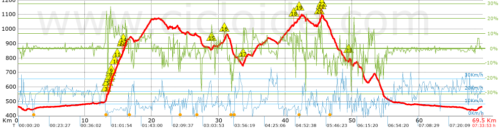
Distance in Km: 69.45
Climb in m: 1632
IBP: 130 BYC

jarcass
Author: jarcass
1336 published routes

Add to my Group or Club

 Height in m      Climb in %      Speed in Km/h      Speed < 2 Km/h

Climbs > 5%

Climbs >5% Climbs >10% Climbs >15% Climbs >20% Climbs >25%
 Steep slope of 312 m.   Average slope  Distances  Download as waypoint
1
 Km 13.079  6%  38 m
2
 Km 13.118  13%  35 m
3
 Km 13.153  19%  32 m
4
 Km 13.185  23%  136 m
5
 Km 13.32  11%  71 m
 Steep slope of 2805 m.  Average slope  Distances  Download as waypoint
6
 Km 13.489  19%  166 m
7
 Km 13.655  13%  130 m
8
 Km 13.785  28%  103 m
9
 Km 13.888  15%  98 m
10
 Km 13.986  14%  336 m
11
 Km 14.322  8%  165 m
12
 Km 14.487  14%  244 m
13
 Km 14.731  9%  131 m
14
 Km 14.862  11%  419 m
15
 Km 15.28  9%  335 m
16
 Km 15.616  11%  34 m
17
 Km 15.65  15%  99 m
18
 Km 15.749  14%  509 m
19
 Km 16.257  11%  36 m
 Steep slope of 236 m.  Average slope  Distances  Download as waypoint
20
 Km 16.615  7%  236 m
 Steep slope of 1810 m.  Average slope  Distances  Download as waypoint
21
 Km 18.09  7%  1810 m
 Steep slope of 174 m.  Average slope  Distances  Download as waypoint
22
 Km 22.496  9%  174 m
 Steep slope of 137 m.  Average slope  Distances  Download as waypoint
23
 Km 23.727  6%  137 m
 Steep slope of 137 m.  Average slope  Distances  Download as waypoint
24
 Km 25.083  6%  137 m
 Steep slope of 107 m.  Average slope  Distances  Download as waypoint
25
 Km 26.358  9%  107 m
 Steep slope of 393 m.  Average slope  Distances  Download as waypoint
26
 Km 28.947  11%  110 m
27
 Km 29.057  7%  283 m
 Steep slope of 137 m.  Average slope  Distances  Download as waypoint
28
 Km 29.906  9%  137 m
 Steep slope of 103 m.  Average slope  Distances  Download as waypoint
29
 Km 30.177  8%  103 m
 Steep slope of 654 m.  Average slope  Distances  Download as waypoint
30
 Km 30.564  7%  270 m
31
 Km 30.834  11%  275 m
32
 Km 31.109  10%  109 m
 Steep slope of 651 m.  Average slope  Distances  Download as waypoint
33
 Km 33.667  12%  479 m
34
 Km 34.146  8%  172 m
 Steep slope of 905 m.  Average slope  Distances  Download as waypoint
35
 Km 35.079  8%  905 m
 Steep slope of 169 m.  Average slope  Distances  Download as waypoint
36
 Km 36.466  5%  169 m
 Steep slope of 181 m.  Average slope  Distances  Download as waypoint
37
 Km 37.117  7%  181 m
 Steep slope of 96 m.  Average slope  Distances  Download as waypoint
38
 Km 38.955  5%  96 m
 Steep slope of 577 m.  Average slope  Distances  Download as waypoint
39
 Km 39.151  7%  577 m
 Steep slope of 135 m.  Average slope  Distances  Download as waypoint
40
 Km 39.862  5%  135 m
 Steep slope of 173 m.  Average slope  Distances  Download as waypoint
41
 Km 40.161  8%  173 m
 Steep slope of 273 m.  Average slope  Distances  Download as waypoint
42
 Km 40.497  7%  273 m
 Steep slope of 241 m.  Average slope  Distances  Download as waypoint
43
 Km 41.249  13%  101 m
44
 Km 41.35  9%  140 m
 Steep slope of 306 m.  Average slope  Distances  Download as waypoint
45
 Km 41.593  9%  306 m
 Steep slope of 304 m.  Average slope  Distances  Download as waypoint
46
 Km 42.099  11%  95 m
47
 Km 42.195  6%  209 m
 Steep slope of 108 m.  Average slope  Distances  Download as waypoint
48
 Km 44.416  7%  108 m
 Steep slope of 446 m.  Average slope  Distances  Download as waypoint
49
 Km 44.741  8%  351 m
50
 Km 45.092  12%  95 m
 Steep slope of 159 m.  Average slope  Distances  Download as waypoint
51
 Km 45.316  9%  32 m
52
 Km 45.348  20%  94 m
53
 Km 45.442  11%  33 m
 Steep slope of 106 m.  Average slope  Distances  Download as waypoint
54
 Km 49.094  10%  106 m
 Steep slope of 111 m.  Average slope  Distances  Download as waypoint
55
 Km 49.495  21%  111 m
 Steep slope of 117 m.  Average slope  Distances  Download as waypoint
56
 Km 50.19  13%  117 m
 Steep slope of 113 m.  Average slope  Distances  Download as waypoint
57
 Km 50.443  6%  113 m
 Steep slope of 310 m.  Average slope  Distances  Download as waypoint
58
 Km 52.422  8%  310 m
 Steep slope of 282 m.  Average slope  Distances  Download as waypoint
59
 Km 52.909  7%  185 m
60
 Km 53.094  9%  97 m
 Steep slope of 217 m.  Average slope  Distances  Download as waypoint
61
 Km 68.744  6%  217 m


Description of the route


Presence of ramps


 Climbs  Distance  % of the total  Speed  Your speed would be  Time  Your time would be
   15 - 30%  1.416  2.04  5.14  ?  0:16:31  ?
   10 - 15%  3.615  5.21  6.51  ?  0:33:18  ?
   5 - 10%  8.742  12.59  8.33  ?  1:02:58  ?
   1 - 5%  10.006  14.41  11.83  ?  0:50:46  ?
   Total*  23.779 Km  34.24 %  8.72 Km/h  ? Km/h    2:43:33 h  ? h  
 Flat
   1 - -1%  20.753 Km  29.88 %  19.36 Km/h  ? Km/h    1:04:20 h  ? h  
 Descents
   -1 - -5%  12.646  18.21  16.07  ?  0:47:13  ?
   -5 - -10%  7.418  10.68  13.75  ?  0:32:22  ?
   -10 - -15%  2.685  3.87  9.45  ?  0:17:03  ?
   -15 - -30%  2.169  3.12  7.89  ?  0:16:30  ?
   Total*  24.919 Km  35.88 %  13.22 Km/h  ? Km/h    1:53:08 h  ? h  
* The total has not necessarily coincide with the sum of the partials after correction of errors

How long would it take you?

How long would it take you to cover this route?
There are routes without a valid time information, but with your average stats you can assess the possible duration

jarcass to cover this route you've need a time of:   5:41:01 h 
If you sign in and have a minimum of two tracks of this same modality, you can know your time for this route, calculated from your stats..


¿Cuanto consumirá tu E-BIKE?

Entra tu E-IBP (formato n,nn)

E-IBP :   X 130 = 


 Detected activity type =  ()
 Penalization due to track conditions: 64 %   ( > 50 % = MTB, < 50 % = RDB)
 Reliability of the track: B   (1645/65/0/-/-/65)
 Correction level applied to the track: 0
DIFFICULTY OF THE ROUTE
IBP = 130 BYC
According to your statistics
 Your time in motion would be: ? h
Your average speed would be: ? Km/h
 

 Total Distance: 69.45 Km
 Analysed distance: 69.45 Km
 Linear distance: 0.01 Km

 Cumulated positive ramps: 1631.86 m  list of points info
 Cumulated negative ramps: 1631.59 m
 Maximum height: 1098.8 m
 Minimum height: 438.3 m
 Climbing Ratio: 6.86 %
 Descent ratio: 6.55 %
 Cumulated postive ramps per Km: 23.5 m
 Cumulated negative ramps per Km: 23.49 m

 Total time: 7:33:53 h
 Time in movement: 5:41:01 h
 According to your statistics
 Your time in motion would be: ? h  
 Stopped time: 1:52:52 h
 Maximum slope filter: ~30 %
 Minimum separation analysed: ~30 m
 Number of points: 5562   (cad. 12.49 m)
 Significant waypoints: 1945   (cad. 35.71 m / 34.97 %)

 Changes in direction per Km: 12.44
 Changes in direction > 5º por Km: 8.29
 Cumulated straight stretches: 15.799 Km
 Straight stretches per Km: 227.49 m
 Penalized slope changes: 17
 Penalized slope changes per Km: 0.245

 Average speed in total: 9.18 Km/h
 Average speed while moving: 12.22 Km/h
 According to your statistics
 Your average speed would be: ? Km/h  
 Maximum sustained speed: 37.01 Km/h


Comments

You can be the first one in commenting this route

 
My comments
:
Add comment  (Registered users)
 
Notify me answers to my comment  Do not notify answers to my comment


Share this route with a friend

Your friend will receive a message with a link to this page:
will see your email and your user name if you do it as registered user.


Write here your name (optional)

E-mail address of your friend(s). You can include various addresses separated by commas

Text or comment (optional) maximum 255 characters long, 255 Available characters

As a non registered users you need to fill-in the captcha text.
  Change image
Type the image characters.
 
 Share with a friend


Visited history

Delete history

Marked routes for review later or compare

My favorites


  Notify anomaly in this route Share in Facebook