Practicando por Cumbres Verdes

MTB
MTB
Ref..: 926678
Published: 24/12/2020
Performed: 23/12/2020
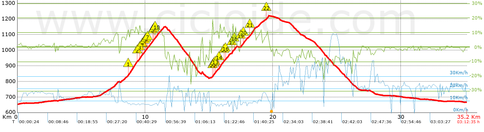
Distance in Km: 35.16
Climb in m: 918
IBP: 75 BYC

Near ...
Ambroz, Armilla, Churriana De La Vega, Gabia La Chica, Granada, Parque Tecnologico De La Salud (Armilla)
Manu_Locos
Author: Manu_Locos
171 published routes

Add to my Group or Club

 Height in m      Climb in %      Speed in Km/h      Speed < 2 Km/h

Climbs > 5%

Climbs >5% Climbs >10% Climbs >15% Climbs >20% Climbs >25%
 Steep slope of 258 m.   Average slope  Distances  Download as waypoint
1
 Km 6.483  5%  258 m
 Steep slope of 104 m.  Average slope  Distances  Download as waypoint
2
 Km 6.857  6%  104 m
 Steep slope of 145 m.  Average slope  Distances  Download as waypoint
3
 Km 7.112  5%  145 m
 Steep slope of 475 m.  Average slope  Distances  Download as waypoint
4
 Km 7.363  8%  475 m
 Steep slope of 326 m.  Average slope  Distances  Download as waypoint
5
 Km 8.058  7%  326 m
 Steep slope of 3044 m.  Average slope  Distances  Download as waypoint
6
 Km 8.488  9%  140 m
7
 Km 8.628  12%  756 m
8
 Km 9.384  10%  134 m
9
 Km 9.518  12%  274 m
10
 Km 9.792  10%  135 m
11
 Km 9.927  10%  176 m
12
 Km 10.103  10%  105 m
13
 Km 10.207  11%  239 m
14
 Km 10.447  9%  96 m
15
 Km 10.543  12%  135 m
16
 Km 10.678  10%  135 m
17
 Km 10.813  11%  375 m
18
 Km 11.187  9%  344 m
 Steep slope of 110 m.  Average slope  Distances  Download as waypoint
19
 Km 14.358  9%  110 m
 Steep slope of 1413 m.  Average slope  Distances  Download as waypoint
20
 Km 15.206  6%  35 m
21
 Km 15.24  14%  132 m
22
 Km 15.372  10%  94 m
23
 Km 15.467  11%  205 m
24
 Km 15.672  6%  133 m
25
 Km 15.805  12%  342 m
26
 Km 16.147  11%  141 m
27
 Km 16.288  11%  233 m
28
 Km 16.521  6%  98 m
 Steep slope of 339 m.  Average slope  Distances  Download as waypoint
29
 Km 16.756  8%  32 m
30
 Km 16.788  17%  98 m
31
 Km 16.886  6%  107 m
32
 Km 16.993  13%  102 m
 Steep slope of 1638 m.  Average slope  Distances  Download as waypoint
33
 Km 17.422  8%  34 m
34
 Km 17.456  11%  98 m
35
 Km 17.554  9%  102 m
36
 Km 17.655  11%  240 m
37
 Km 17.895  8%  237 m
38
 Km 18.132  11%  413 m
39
 Km 18.545  8%  514 m
 Steep slope of 382 m.  Average slope  Distances  Download as waypoint
40
 Km 19.21  6%  247 m
41
 Km 19.457  11%  135 m


Description of the route


Presence of ramps


 Climbs  Distance  % of the total  Speed  Your speed would be  Time  Your time would be
   15 - 30%  0.335  0.95  5.58  ?  0:03:36  ?
   10 - 15%  3.9  11.09  9.04  ?  0:25:53  ?
   5 - 10%  4.105  11.68  9.5  ?  0:25:55  ?
   1 - 5%  4.174  11.87  13.22  ?  0:18:57  ?
   Total*  12.514 Km  35.6 %  10.1 Km/h  ? Km/h    1:14:21 h  ? h  
 Flat
   1 - -1%  8.238 Km  23.43 %  18.25 Km/h  ? Km/h    0:27:05 h  ? h  
 Descents
   -1 - -5%  6.206  17.65  19.91  ?  0:18:42  ?
   -5 - -10%  5.529  15.73  25.32  ?  0:13:06  ?
   -10 - -15%  2.067  5.88  16.14  ?  0:07:41  ?
   -15 - -30%  0.602  1.71  8.96  ?  0:04:02  ?
   Total*  14.404 Km  40.97 %  19.86 Km/h  ? Km/h    0:43:31 h  ? h  
* The total has not necessarily coincide with the sum of the partials after correction of errors

How long would it take you?

How long would it take you to cover this route?
There are routes without a valid time information, but with your average stats you can assess the possible duration

Manu_Locos to cover this route you've need a time of:   2:24:57 h 
If you sign in and have a minimum of two tracks of this same modality, you can know your time for this route, calculated from your stats..


¿Cuanto consumirá tu E-BIKE?

Entra tu E-IBP (formato n,nn)

E-IBP :   X 75 = 


 Detected activity type =  ()
 Penalization due to track conditions: 56 %   ( > 50 % = MTB, < 50 % = RDB)
 Reliability of the track: A   (918/87/0/-/-/87)
 Correction level applied to the track: 0
DIFFICULTY OF THE ROUTE
IBP = 75 BYC
According to your statistics
 Your time in motion would be: ? h
Your average speed would be: ? Km/h
 

 Total Distance: 35.16 Km
 Analysed distance: 35.16 Km
 Linear distance: 0.03 Km

 Cumulated positive ramps: 917.64 m  list of points info
 Cumulated negative ramps: 906.44 m
 Maximum height: 1217.6 m
 Minimum height: 652 m
 Climbing Ratio: 7.33 %
 Descent ratio: 6.29 %
 Cumulated postive ramps per Km: 26.1 m
 Cumulated negative ramps per Km: 25.78 m

 Total time: 3:12:35 h
 Time in movement: 2:24:57 h
 According to your statistics
 Your time in motion would be: ? h  
 Stopped time: 0:47:38 h
 Maximum slope filter: ~30 %
 Minimum separation analysed: ~30 m
 Number of points: 2804   (cad. 12.54 m)
 Significant waypoints: 979   (cad. 35.91 m / 34.91 %)

 Changes in direction per Km: 12.23
 Changes in direction > 5º por Km: 6.94
 Cumulated straight stretches: 10.426 Km
 Straight stretches per Km: 296.53 m
 Penalized slope changes: 7
 Penalized slope changes per Km: 0.199

 Average speed in total: 10.95 Km/h
 Average speed while moving: 14.55 Km/h
 According to your statistics
 Your average speed would be: ? Km/h  
 Maximum sustained speed: 67.35 Km/h


Comments

You can be the first one in commenting this route

 
My comments
:
Add comment  (Registered users)
 
Notify me answers to my comment  Do not notify answers to my comment


Share this route with a friend

Your friend will receive a message with a link to this page:
will see your email and your user name if you do it as registered user.


Write here your name (optional)

E-mail address of your friend(s). You can include various addresses separated by commas

Text or comment (optional) maximum 255 characters long, 255 Available characters

As a non registered users you need to fill-in the captcha text.
  Change image
Type the image characters.
 
 Share with a friend


Visited history

Delete history

Marked routes for review later or compare

My favorites


  Notify anomaly in this route Share in Facebook