Hospitalet De Llobregat, L' (Barcelona)

MTB
MTB
Ref..: 924010
Published: 12/12/2020
Performed: 11/12/2020
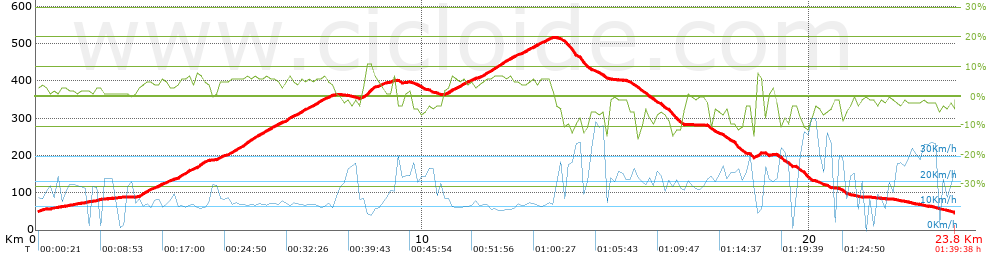
Distance in Km: 23.82
Climb in m: 533
IBP: 33 BYC

Miquel_Angel_Caelles
574 published routes

Add to my Group or Club

 Height in m      Climb in %      Speed in Km/h      Speed < 2 Km/h

Climbs > 5%

Climbs >5% Climbs >10% Climbs >15% Climbs >20% Climbs >25%
 Steep slope of 203 m.   Average slope  Distances  Download as waypoint
1
 Km 2.662  6%  203 m
 Steep slope of 114 m.  Average slope  Distances  Download as waypoint
2
 Km 3.25  5%  114 m
 Steep slope of 711 m.  Average slope  Distances  Download as waypoint
3
 Km 3.663  6%  711 m
 Steep slope of 592 m.  Average slope  Distances  Download as waypoint
4
 Km 4.918  6%  592 m
 Steep slope of 695 m.  Average slope  Distances  Download as waypoint
5
 Km 5.612  6%  695 m
 Steep slope of 209 m.  Average slope  Distances  Download as waypoint
6
 Km 6.407  7%  209 m
 Steep slope of 300 m.  Average slope  Distances  Download as waypoint
7
 Km 6.808  6%  300 m
 Steep slope of 377 m.  Average slope  Distances  Download as waypoint
8
 Km 7.204  6%  377 m
 Steep slope of 355 m.  Average slope  Distances  Download as waypoint
9
 Km 8.499  8%  33 m
10
 Km 8.532  10%  107 m
11
 Km 8.639  7%  215 m
 Steep slope of 256 m.  Average slope  Distances  Download as waypoint
12
 Km 10.566  5%  256 m
 Steep slope of 259 m.  Average slope  Distances  Download as waypoint
13
 Km 10.966  5%  259 m
 Steep slope of 208 m.  Average slope  Distances  Download as waypoint
14
 Km 11.465  6%  208 m
 Steep slope of 577 m.  Average slope  Distances  Download as waypoint
15
 Km 11.786  6%  577 m
 Steep slope of 390 m.  Average slope  Distances  Download as waypoint
16
 Km 12.835  6%  390 m
 Steep slope of 202 m.  Average slope  Distances  Download as waypoint
17
 Km 18.599  7%  202 m


Description of the route


Presence of ramps


 Climbs  Distance  % of the total  Speed  Your speed would be  Time  Your time would be
   15 - 30%  0  0  0  ?  0:00:00  ?
   10 - 15%  0.107  0.45  8.39  ?  0:00:46  ?
   5 - 10%  5.557  23.33  11.32  ?  0:29:28  ?
   1 - 5%  5.488  23.04  12.54  ?  0:26:15  ?
   Total*  11.152 Km  46.83 %  11.85 Km/h  ? Km/h    0:56:29 h  ? h  
 Flat
   1 - -1%  3.064 Km  12.86 %  14.32 Km/h  ? Km/h    0:12:50 h  ? h  
 Descents
   -1 - -5%  5.054  21.22  17.28  ?  0:17:33  ?
   -5 - -10%  3.252  13.66  22.01  ?  0:08:52  ?
   -10 - -15%  1.177  4.94  20.28  ?  0:03:29  ?
   -15 - -30%  0.116  0.49  16.7  ?  0:00:25  ?
   Total*  9.6 Km  40.31 %  19 Km/h  ? Km/h    0:30:19 h  ? h  
* The total has not necessarily coincide with the sum of the partials after correction of errors

How long would it take you?

How long would it take you to cover this route?
There are routes without a valid time information, but with your average stats you can assess the possible duration

Miquel_Angel_Caelles to cover this route you've need a time of:   1:39:38 h 
If you sign in and have a minimum of two tracks of this same modality, you can know your time for this route, calculated from your stats..


¿Cuanto consumirá tu E-BIKE?

Entra tu E-IBP (formato n,nn)

E-IBP :   X 33 = 


 Detected activity type =  ()
 Penalization due to track conditions: 61 %   ( > 50 % = MTB, < 50 % = RDB)
 Reliability of the track: A   (533/89/0/-/-/89)
 Correction level applied to the track: 0
DIFFICULTY OF THE ROUTE
IBP = 33 BYC
According to your statistics
 Your time in motion would be: ? h
Your average speed would be: ? Km/h
 

 Total Distance: 23.82 Km
 Analysed distance: 23.82 Km
 Linear distance: 0.01 Km

 Cumulated positive ramps: 532.8 m  list of points info
 Cumulated negative ramps: 534.4 m
 Maximum height: 516.8 m
 Minimum height: 45.8 m
 Climbing Ratio: 4.78 %
 Descent ratio: 5.57 %
 Cumulated postive ramps per Km: 22.37 m
 Cumulated negative ramps per Km: 22.43 m

 Total time: 1:39:38 h
 Time in movement: 1:39:38 h
 According to your statistics
 Your time in motion would be: ? h  
 Stopped time: 0:00:00 h
 Maximum slope filter: ~30 %
 Minimum separation analysed: ~30 m
 Number of points: 1898   (cad. 12.55 m)
 Significant waypoints: 666   (cad. 35.76 m / 35.09 %)

 Changes in direction per Km: 11.75
 Changes in direction > 5º por Km: 7.81
 Cumulated straight stretches: 4.355 Km
 Straight stretches per Km: 182.83 m
 Penalized slope changes: 4
 Penalized slope changes per Km: 0.168

 Average speed in total: 14.34 Km/h
 Average speed while moving: 14.34 Km/h
 According to your statistics
 Your average speed would be: ? Km/h  
 Maximum sustained speed: 46.46 Km/h


Comments

You can be the first one in commenting this route

 
My comments
:
Add comment  (Registered users)
 
Notify me answers to my comment  Do not notify answers to my comment


Share this route with a friend

Your friend will receive a message with a link to this page:
will see your email and your user name if you do it as registered user.


Write here your name (optional)

E-mail address of your friend(s). You can include various addresses separated by commas

Text or comment (optional) maximum 255 characters long, 255 Available characters

As a non registered users you need to fill-in the captcha text.
  Change image
Type the image characters.
 
 Share with a friend


Visited history

Delete history

Marked routes for review later or compare

My favorites


  Notify anomaly in this route Share in Facebook