Santa Susanna (Barcelona)

MTB
MTB
Ref..: 919218
Published: 18/11/2020
Performed: 18/11/2020
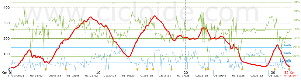
Distance in Km: 31.97
Climb in m: 1135
IBP: 108 BYC

Ramon 4
Author: Ramon 4
607 published routes

Add to my Group or Club

 Height in m      Climb in %      Speed in Km/h      Speed < 2 Km/h

Climbs > 10%

Climbs >5% Climbs >10% Climbs >15% Climbs >20% Climbs >25%
 Steep slope of 328 m.   Average slope  Distances  Download as waypoint
1
 Km 1.341  11%  192 m
2
 Km 1.785  14%  136 m
 Steep slope of 101 m.  Average slope  Distances  Download as waypoint
3
 Km 2.468  11%  101 m
 Steep slope of 301 m.  Average slope  Distances  Download as waypoint
4
 Km 4.789  12%  167 m
5
 Km 4.957  10%  99 m
6
 Km 5.056  12%  134 m
 Steep slope of 232 m.  Average slope  Distances  Download as waypoint
7
 Km 5.456  16%  133 m
8
 Km 5.589  16%  99 m
 Steep slope of 140 m.  Average slope  Distances  Download as waypoint
9
 Km 5.872  15%  140 m
 Steep slope of 233 m.  Average slope  Distances  Download as waypoint
10
 Km 6.745  10%  103 m
 Steep slope of 996 m.  Average slope  Distances  Download as waypoint
11
 Km 13.674  12%  172 m
12
 Km 13.846  17%  172 m
13
 Km 14.018  14%  139 m
14
 Km 14.156  10%  198 m
15
 Km 14.354  12%  201 m
16
 Km 14.691  13%  108 m
17
 Km 15.277  14%  35 m
18
 Km 15.311  15%  103 m
19
 Km 15.415  15%  66 m
 Steep slope of 210 m.  Average slope  Distances  Download as waypoint
20
 Km 15.778  12%  210 m
 Steep slope of 104 m.  Average slope  Distances  Download as waypoint
21
 Km 18.923  14%  104 m
 Steep slope of 426 m.  Average slope  Distances  Download as waypoint
22
 Km 21.447  10%  201 m
23
 Km 21.648  17%  34 m
24
 Km 21.682  16%  94 m
25
 Km 21.776  21%  64 m
26
 Km 21.84  22%  33 m
 Steep slope of 138 m.  Average slope  Distances  Download as waypoint
27
 Km 25.331  16%  138 m
 Steep slope of 675 m.  Average slope  Distances  Download as waypoint
28
 Km 29.496  14%  534 m
29
 Km 30.272  16%  34 m
30
 Km 30.306  14%  70 m


Description of the route


Presence of ramps


 Climbs  Distance  % of the total  Speed  Your speed would be  Time  Your time would be
   15 - 30%  1.45  4.54  7.05  ?  0:12:20  ?
   10 - 15%  3.258  10.19  7.86  ?  0:24:52  ?
   5 - 10%  4.55  14.23  10.34  ?  0:26:24  ?
   1 - 5%  4.786  14.97  10.91  ?  0:26:20  ?
   Total*  14.044 Km  43.93 %  9.37 Km/h  ? Km/h    1:29:56 h  ? h  
 Flat
   1 - -1%  3.654 Km  11.43 %  15.85 Km/h  ? Km/h    0:13:50 h  ? h  
 Descents
   -1 - -5%  5.814  18.19  17.23  ?  0:20:15  ?
   -5 - -10%  4.257  13.32  16.57  ?  0:15:25  ?
   -10 - -15%  2.428  7.6  12.3  ?  0:11:51  ?
   -15 - -30%  1.769  5.53  6.75  ?  0:15:43  ?
   Total*  14.268 Km  44.64 %  13.54 Km/h  ? Km/h    1:03:14 h  ? h  
* The total has not necessarily coincide with the sum of the partials after correction of errors

How long would it take you?

How long would it take you to cover this route?
There are routes without a valid time information, but with your average stats you can assess the possible duration

Ramon 4 to cover this route you've need a time of:   2:47:00 h 
If you sign in and have a minimum of two tracks of this same modality, you can know your time for this route, calculated from your stats..


¿Cuanto consumirá tu E-BIKE?

Entra tu E-IBP (formato n,nn)

E-IBP :   X 108 = 


 Detected activity type =  ()
 Penalization due to track conditions: 72 %   ( > 50 % = MTB, < 50 % = RDB)
 Reliability of the track: B   (1135/67/0/-/-/67)
 Correction level applied to the track: 0
DIFFICULTY OF THE ROUTE
IBP = 108 BYC
According to your statistics
 Your time in motion would be: ? h
Your average speed would be: ? Km/h
 

 Total Distance: 31.97 Km
 Analysed distance: 31.97 Km
 Linear distance: 0.02 Km

 Cumulated positive ramps: 1135.2 m  list of points info
 Cumulated negative ramps: 1123.8 m
 Maximum height: 349.6 m
 Minimum height: 13 m
 Climbing Ratio: 8.08 %
 Descent ratio: 7.88 %
 Cumulated postive ramps per Km: 35.51 m
 Cumulated negative ramps per Km: 35.15 m

 Total time: 4:05:39 h
 Time in movement: 2:47:00 h
 According to your statistics
 Your time in motion would be: ? h  
 Stopped time: 1:18:39 h
 Maximum slope filter: ~30 %
 Minimum separation analysed: ~30 m
 Number of points: 2674   (cad. 11.95 m)
 Significant waypoints: 907   (cad. 35.24 m / 33.92 %)

 Changes in direction per Km: 12.7
 Changes in direction > 5º por Km: 10.89
 Cumulated straight stretches: 3.245 Km
 Straight stretches per Km: 101.5 m
 Penalized slope changes: 10
 Penalized slope changes per Km: 0.313

 Average speed in total: 7.81 Km/h
 Average speed while moving: 11.49 Km/h
 According to your statistics
 Your average speed would be: ? Km/h  
 Maximum sustained speed: 44.04 Km/h


Comments

You can be the first one in commenting this route

 
My comments
:
Add comment  (Registered users)
 
Notify me answers to my comment  Do not notify answers to my comment


Share this route with a friend

Your friend will receive a message with a link to this page:
will see your email and your user name if you do it as registered user.


Write here your name (optional)

E-mail address of your friend(s). You can include various addresses separated by commas

Text or comment (optional) maximum 255 characters long, 255 Available characters

As a non registered users you need to fill-in the captcha text.
  Change image
Type the image characters.
 
 Share with a friend


Visited history

Delete history

Marked routes for review later or compare

My favorites


  Notify anomaly in this route Share in Facebook