Ni antibarro ni pollas... _ jartá de barro pa rabiar

MTB
MTB
Ref..: 916715
Published: 08/11/2020
Performed: 07/11/2020
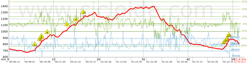
Distance in Km: 51.43
Climb in m: 1340
IBP: 93 BYC

fernan2g
Author: fernan2g
1943 published routes

Add to my Group or Club

 Height in m      Climb in %      Speed in Km/h      Speed < 2 Km/h

Climbs > 5%

Climbs >5% Climbs >10% Climbs >15% Climbs >20% Climbs >25%
 Steep slope of 499 m.   Average slope  Distances  Download as waypoint
1
 Km 5.762  5%  33 m
2
 Km 5.796  12%  212 m
3
 Km 6.008  9%  254 m
 Steep slope of 705 m.  Average slope  Distances  Download as waypoint
4
 Km 6.622  7%  224 m
5
 Km 6.846  12%  187 m
6
 Km 7.033  12%  160 m
7
 Km 7.193  18%  104 m
8
 Km 7.297  10%  30 m
 Steep slope of 256 m.  Average slope  Distances  Download as waypoint
9
 Km 7.607  9%  256 m
 Steep slope of 325 m.  Average slope  Distances  Download as waypoint
10
 Km 8.496  5%  40 m
11
 Km 8.536  11%  186 m
12
 Km 8.722  9%  99 m
 Steep slope of 241 m.  Average slope  Distances  Download as waypoint
13
 Km 8.967  8%  241 m
 Steep slope of 161 m.  Average slope  Distances  Download as waypoint
14
 Km 9.568  6%  161 m
 Steep slope of 1226 m.  Average slope  Distances  Download as waypoint
15
 Km 10.969  7%  1226 m
 Steep slope of 462 m.  Average slope  Distances  Download as waypoint
16
 Km 12.993  12%  231 m
17
 Km 13.224  9%  231 m
 Steep slope of 145 m.  Average slope  Distances  Download as waypoint
18
 Km 13.57  11%  145 m
 Steep slope of 111 m.  Average slope  Distances  Download as waypoint
19
 Km 13.83  8%  111 m
 Steep slope of 114 m.  Average slope  Distances  Download as waypoint
20
 Km 14.367  8%  114 m
 Steep slope of 695 m.  Average slope  Distances  Download as waypoint
21
 Km 14.95  14%  37 m
22
 Km 14.987  19%  108 m
23
 Km 15.095  8%  550 m
 Steep slope of 145 m.  Average slope  Distances  Download as waypoint
24
 Km 15.89  11%  145 m
 Steep slope of 107 m.  Average slope  Distances  Download as waypoint
25
 Km 16.208  6%  107 m
 Steep slope of 376 m.  Average slope  Distances  Download as waypoint
26
 Km 16.496  8%  38 m
27
 Km 16.534  12%  217 m
28
 Km 16.751  9%  121 m
 Steep slope of 360 m.  Average slope  Distances  Download as waypoint
29
 Km 17.578  6%  360 m
 Steep slope of 375 m.  Average slope  Distances  Download as waypoint
30
 Km 18.674  7%  375 m
 Steep slope of 178 m.  Average slope  Distances  Download as waypoint
31
 Km 21.5  7%  178 m
 Steep slope of 1120 m.  Average slope  Distances  Download as waypoint
32
 Km 23.234  7%  1120 m
 Steep slope of 135 m.  Average slope  Distances  Download as waypoint
33
 Km 25.138  7%  135 m
 Steep slope of 857 m.  Average slope  Distances  Download as waypoint
34
 Km 26.035  6%  857 m
 Steep slope of 106 m.  Average slope  Distances  Download as waypoint
35
 Km 27.755  5%  106 m
 Steep slope of 104 m.  Average slope  Distances  Download as waypoint
36
 Km 28.045  8%  104 m
 Steep slope of 163 m.  Average slope  Distances  Download as waypoint
37
 Km 30.362  6%  163 m
 Steep slope of 180 m.  Average slope  Distances  Download as waypoint
38
 Km 31.524  7%  180 m
 Steep slope of 142 m.  Average slope  Distances  Download as waypoint
39
 Km 34.118  9%  142 m
 Steep slope of 107 m.  Average slope  Distances  Download as waypoint
40
 Km 35.902  8%  107 m
 Steep slope of 331 m.  Average slope  Distances  Download as waypoint
41
 Km 37.608  7%  331 m
 Steep slope of 100 m.  Average slope  Distances  Download as waypoint
42
 Km 47.632  9%  100 m
 Steep slope of 277 m.  Average slope  Distances  Download as waypoint
43
 Km 47.917  8%  71 m
44
 Km 47.988  10%  172 m
45
 Km 48.16  11%  34 m
 Steep slope of 975 m.  Average slope  Distances  Download as waypoint
46
 Km 48.335  7%  116 m
47
 Km 48.451  16%  141 m
48
 Km 48.591  12%  395 m
49
 Km 48.986  15%  99 m
50
 Km 49.085  12%  33 m
51
 Km 49.118  8%  191 m


Description of the route


Presence of ramps


 Climbs  Distance  % of the total  Speed  Your speed would be  Time  Your time would be
   15 - 30%  0.636  1.24  12.79  ?  0:02:59  ?
   10 - 15%  2.333  4.54  14.29  ?  0:09:48  ?
   5 - 10%  8.844  17.2  17.41  ?  0:30:29  ?
   1 - 5%  11.713  22.78  19.63  ?  0:35:48  ?
   Total*  23.526 Km  45.75 %  17.85 Km/h  ? Km/h    1:19:04 h  ? h  
 Flat
   1 - -1%  7.867 Km  15.3 %  22.64 Km/h  ? Km/h    0:20:51 h  ? h  
 Descents
   -1 - -5%  11.068  21.52  24.89  ?  0:26:41  ?
   -5 - -10%  4.652  9.05  28.19  ?  0:09:54  ?
   -10 - -15%  2.606  5.07  29.6  ?  0:05:17  ?
   -15 - -30%  1.71  3.33  24.72  ?  0:04:09  ?
   Total*  20.036 Km  38.96 %  26.12 Km/h  ? Km/h    0:46:01 h  ? h  
* The total has not necessarily coincide with the sum of the partials after correction of errors

How long would it take you?

How long would it take you to cover this route?
There are routes without a valid time information, but with your average stats you can assess the possible duration

fernan2g to cover this route you've need a time of:   2:25:56 h 
If you sign in and have a minimum of two tracks of this same modality, you can know your time for this route, calculated from your stats..


¿Cuanto consumirá tu E-BIKE?

Entra tu E-IBP (formato n,nn)

E-IBP :   X 93 = 


 Detected activity type =  ()
 Penalization due to track conditions: 61 %   ( > 50 % = MTB, < 50 % = RDB)
 Reliability of the track: A   (1340/73/0/-/-/73)
 Correction level applied to the track: 0
DIFFICULTY OF THE ROUTE
IBP = 93 BYC
According to your statistics
 Your time in motion would be: ? h
Your average speed would be: ? Km/h
 

 Total Distance: 51.43 Km
 Analysed distance: 51.43 Km
 Linear distance: 0.73 Km

 Cumulated positive ramps: 1340.1 m  list of points info
 Cumulated negative ramps: 1254.5 m
 Maximum height: 1400.7 m
 Minimum height: 674.4 m
 Climbing Ratio: 5.7 %
 Descent ratio: 6.26 %
 Cumulated postive ramps per Km: 26.06 m
 Cumulated negative ramps per Km: 24.39 m

 Total time: 2:29:02 h
 Time in movement: 2:25:56 h
 According to your statistics
 Your time in motion would be: ? h  
 Stopped time: 0:03:06 h
 Maximum slope filter: ~30 %
 Minimum separation analysed: ~30 m
 Number of points: 3931   (cad. 13.08 m)
 Significant waypoints: 1421   (cad. 36.19 m / 36.15 %)

 Changes in direction per Km: 11.61
 Changes in direction > 5º por Km: 8.11
 Cumulated straight stretches: 11.139 Km
 Straight stretches per Km: 216.59 m
 Penalized slope changes: 12
 Penalized slope changes per Km: 0.233

 Average speed in total: 20.71 Km/h
 Average speed while moving: 21.15 Km/h
 According to your statistics
 Your average speed would be: ? Km/h  
 Maximum sustained speed: 48.69 Km/h


Comments

You can be the first one in commenting this route

 
My comments
:
Add comment  (Registered users)
 
Notify me answers to my comment  Do not notify answers to my comment


Share this route with a friend

Your friend will receive a message with a link to this page:
will see your email and your user name if you do it as registered user.


Write here your name (optional)

E-mail address of your friend(s). You can include various addresses separated by commas

Text or comment (optional) maximum 255 characters long, 255 Available characters

As a non registered users you need to fill-in the captcha text.
  Change image
Type the image characters.
 
 Share with a friend


Visited history

Delete history

Marked routes for review later or compare

My favorites


  Notify anomaly in this route Share in Facebook