Esparreguera (Barcelona)

MTB
MTB
Ref..: 915399
Published: 02/11/2020
Performed: 01/11/2020
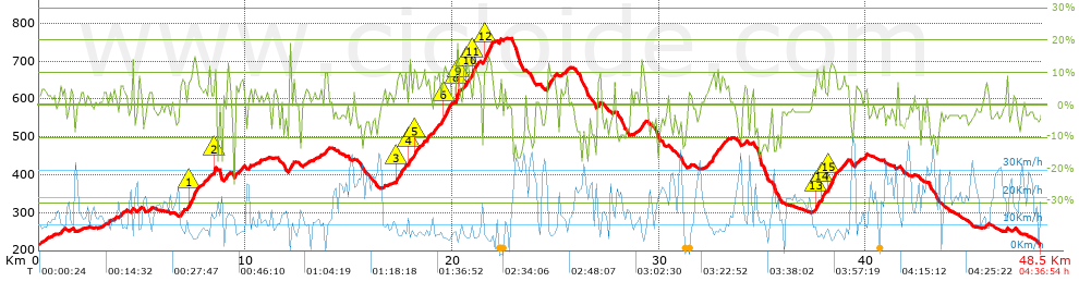
Distance in Km: 48.52
Climb in m: 1300
IBP: 95 BYC

Antonio_Cuevas
201 published routes

Add to my Group or Club

 Height in m      Climb in %      Speed in Km/h      Speed < 2 Km/h

Climbs > 5%

Climbs >5% Climbs >10% Climbs >15% Climbs >20% Climbs >25%
 Steep slope of 199 m.   Average slope  Distances  Download as waypoint
1
 Km 3.933  6%  199 m
 Steep slope of 124 m.  Average slope  Distances  Download as waypoint
2
 Km 4.814  8%  124 m
 Steep slope of 239 m.  Average slope  Distances  Download as waypoint
3
 Km 6.845  7%  239 m
 Steep slope of 540 m.  Average slope  Distances  Download as waypoint
4
 Km 7.194  8%  114 m
5
 Km 7.308  12%  270 m
6
 Km 7.579  9%  156 m
 Steep slope of 134 m.  Average slope  Distances  Download as waypoint
7
 Km 7.965  7%  134 m
 Steep slope of 111 m.  Average slope  Distances  Download as waypoint
8
 Km 8.197  9%  111 m
 Steep slope of 126 m.  Average slope  Distances  Download as waypoint
9
 Km 8.451  13%  126 m
 Steep slope of 219 m.  Average slope  Distances  Download as waypoint
10
 Km 8.973  9%  219 m
 Steep slope of 198 m.  Average slope  Distances  Download as waypoint
11
 Km 9.51  7%  198 m
 Steep slope of 115 m.  Average slope  Distances  Download as waypoint
12
 Km 10.153  8%  115 m
 Steep slope of 210 m.  Average slope  Distances  Download as waypoint
13
 Km 12.105  12%  210 m
 Steep slope of 189 m.  Average slope  Distances  Download as waypoint
14
 Km 13.83  9%  189 m
 Steep slope of 453 m.  Average slope  Distances  Download as waypoint
15
 Km 17.265  9%  31 m
16
 Km 17.295  10%  163 m
17
 Km 17.458  8%  259 m
 Steep slope of 153 m.  Average slope  Distances  Download as waypoint
18
 Km 17.864  6%  34 m
19
 Km 17.898  13%  119 m
 Steep slope of 251 m.  Average slope  Distances  Download as waypoint
20
 Km 18.134  11%  140 m
21
 Km 18.274  6%  111 m
 Steep slope of 298 m.  Average slope  Distances  Download as waypoint
22
 Km 18.547  7%  298 m
 Steep slope of 345 m.  Average slope  Distances  Download as waypoint
23
 Km 18.982  6%  345 m
 Steep slope of 478 m.  Average slope  Distances  Download as waypoint
24
 Km 19.451  8%  121 m
25
 Km 19.571  11%  259 m
26
 Km 19.83  10%  98 m
 Steep slope of 186 m.  Average slope  Distances  Download as waypoint
27
 Km 20.159  12%  34 m
28
 Km 20.192  18%  109 m
29
 Km 20.302  14%  43 m
 Steep slope of 340 m.  Average slope  Distances  Download as waypoint
30
 Km 20.511  7%  176 m
31
 Km 20.687  12%  114 m
32
 Km 20.802  7%  50 m
 Steep slope of 317 m.  Average slope  Distances  Download as waypoint
33
 Km 20.975  12%  168 m
34
 Km 21.143  9%  149 m
 Steep slope of 535 m.  Average slope  Distances  Download as waypoint
35
 Km 21.488  7%  39 m
36
 Km 21.527  12%  384 m
37
 Km 21.911  7%  112 m
 Steep slope of 467 m.  Average slope  Distances  Download as waypoint
38
 Km 24.562  9%  467 m
 Steep slope of 140 m.  Average slope  Distances  Download as waypoint
39
 Km 25.458  8%  140 m
 Steep slope of 193 m.  Average slope  Distances  Download as waypoint
40
 Km 27.012  9%  193 m
 Steep slope of 251 m.  Average slope  Distances  Download as waypoint
41
 Km 29.106  9%  251 m
 Steep slope of 273 m.  Average slope  Distances  Download as waypoint
42
 Km 32.402  9%  273 m
 Steep slope of 311 m.  Average slope  Distances  Download as waypoint
43
 Km 32.794  8%  311 m
 Steep slope of 124 m.  Average slope  Distances  Download as waypoint
44
 Km 33.241  7%  124 m
 Steep slope of 102 m.  Average slope  Distances  Download as waypoint
45
 Km 34.138  5%  102 m
 Steep slope of 421 m.  Average slope  Distances  Download as waypoint
46
 Km 37.603  11%  143 m
47
 Km 37.746  6%  116 m
48
 Km 37.862  11%  162 m
 Steep slope of 662 m.  Average slope  Distances  Download as waypoint
49
 Km 38.158  12%  354 m
50
 Km 38.512  6%  308 m
 Steep slope of 203 m.  Average slope  Distances  Download as waypoint
51
 Km 38.936  7%  203 m
 Steep slope of 187 m.  Average slope  Distances  Download as waypoint
52
 Km 39.474  6%  187 m


Description of the route


Presence of ramps


 Climbs  Distance  % of the total  Speed  Your speed would be  Time  Your time would be
   15 - 30%  0.403  0.83  5.16  ?  0:04:41  ?
   10 - 15%  3.123  6.44  6.85  ?  0:27:21  ?
   5 - 10%  7.423  15.3  8.81  ?  0:50:33  ?
   1 - 5%  10.259  21.14  11.32  ?  0:54:24  ?
   Total*  21.208 Km  43.71 %  9.29 Km/h  ? Km/h    2:16:59 h  ? h  
 Flat
   1 - -1%  5.449 Km  11.23 %  12.97 Km/h  ? Km/h    0:25:12 h  ? h  
 Descents
   -1 - -5%  11.887  24.5  18.77  ?  0:38:00  ?
   -5 - -10%  6.281  12.95  21.33  ?  0:17:40  ?
   -10 - -15%  2.741  5.65  16.02  ?  0:10:16  ?
   -15 - -30%  0.957  1.97  14.6  ?  0:03:56  ?
   Total*  21.867 Km  45.06 %  18.78 Km/h  ? Km/h    1:09:52 h  ? h  
* The total has not necessarily coincide with the sum of the partials after correction of errors

How long would it take you?

How long would it take you to cover this route?
There are routes without a valid time information, but with your average stats you can assess the possible duration

Antonio_Cuevas to cover this route you've need a time of:   3:52:03 h 
If you sign in and have a minimum of two tracks of this same modality, you can know your time for this route, calculated from your stats..


¿Cuanto consumirá tu E-BIKE?

Entra tu E-IBP (formato n,nn)

E-IBP :   X 95 = 


 Detected activity type =  ()
 Penalization due to track conditions: 73 %   ( > 50 % = MTB, < 50 % = RDB)
 Reliability of the track: B   (1300/65/0/-/-/65)
 Correction level applied to the track: 0
DIFFICULTY OF THE ROUTE
IBP = 95 BYC
According to your statistics
 Your time in motion would be: ? h
Your average speed would be: ? Km/h
 

 Total Distance: 48.52 Km
 Analysed distance: 48.52 Km
 Linear distance: 0.02 Km

 Cumulated positive ramps: 1300.2 m  list of points info
 Cumulated negative ramps: 1303 m
 Maximum height: 759.8 m
 Minimum height: 214.2 m
 Climbing Ratio: 6.13 %
 Descent ratio: 5.96 %
 Cumulated postive ramps per Km: 26.8 m
 Cumulated negative ramps per Km: 26.85 m

 Total time: 4:36:54 h
 Time in movement: 3:52:03 h
 According to your statistics
 Your time in motion would be: ? h  
 Stopped time: 0:44:51 h
 Maximum slope filter: ~30 %
 Minimum separation analysed: ~30 m
 Number of points: 2338   (cad. 20.75 m)
 Significant waypoints: 1165   (cad. 41.65 m / 49.83 %)

 Changes in direction per Km: 10.63
 Changes in direction > 5º por Km: 8.33
 Cumulated straight stretches: 6.978 Km
 Straight stretches per Km: 143.82 m
 Penalized slope changes: 12
 Penalized slope changes per Km: 0.247

 Average speed in total: 10.51 Km/h
 Average speed while moving: 12.55 Km/h
 According to your statistics
 Your average speed would be: ? Km/h  
 Maximum sustained speed: 41.24 Km/h


Comments

You can be the first one in commenting this route

 
My comments
:
Add comment  (Registered users)
 
Notify me answers to my comment  Do not notify answers to my comment


Share this route with a friend

Your friend will receive a message with a link to this page:
will see your email and your user name if you do it as registered user.


Write here your name (optional)

E-mail address of your friend(s). You can include various addresses separated by commas

Text or comment (optional) maximum 255 characters long, 255 Available characters

As a non registered users you need to fill-in the captcha text.
  Change image
Type the image characters.
 
 Share with a friend


Visited history

Delete history

Marked routes for review later or compare

My favorites


  Notify anomaly in this route Share in Facebook