2020 10 20 purchedornajohazallanas

MTB
MTB
Ref..: 912719
Published: 21/10/2020
Performed: 20/10/2020
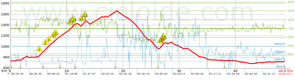
Distance in Km: 48.8
Climb in m: 1304
IBP: 96 BYC


 Height in m      Climb in %      Speed in Km/h      Speed < 2 Km/h

Climbs > 5%

Climbs >5% Climbs >10% Climbs >15% Climbs >20% Climbs >25%
 Steep slope of 144 m.   Average slope  Distances  Download as waypoint
1
 Km 0.959  6%  144 m
 Steep slope of 346 m.  Average slope  Distances  Download as waypoint
2
 Km 1.853  7%  346 m
 Steep slope of 147 m.  Average slope  Distances  Download as waypoint
3
 Km 2.306  7%  147 m
 Steep slope of 141 m.  Average slope  Distances  Download as waypoint
4
 Km 2.623  7%  141 m
 Steep slope of 2288 m.  Average slope  Distances  Download as waypoint
5
 Km 4.994  7%  106 m
6
 Km 5.101  11%  855 m
7
 Km 5.956  9%  176 m
8
 Km 6.132  11%  388 m
9
 Km 6.52  9%  219 m
10
 Km 6.74  11%  403 m
11
 Km 7.142  10%  141 m
 Steep slope of 1727 m.  Average slope  Distances  Download as waypoint
12
 Km 7.451  7%  104 m
13
 Km 7.555  12%  175 m
14
 Km 7.73  7%  110 m
15
 Km 7.84  11%  149 m
16
 Km 7.989  8%  111 m
17
 Km 8.101  11%  150 m
18
 Km 8.25  8%  928 m
 Steep slope of 2061 m.  Average slope  Distances  Download as waypoint
19
 Km 9.293  8%  1241 m
20
 Km 10.535  12%  143 m
21
 Km 10.677  8%  318 m
22
 Km 10.995  13%  109 m
23
 Km 11.104  16%  104 m
24
 Km 11.207  14%  146 m
 Steep slope of 810 m.  Average slope  Distances  Download as waypoint
25
 Km 12.583  10%  31 m
26
 Km 12.615  12%  525 m
27
 Km 13.14  11%  113 m
28
 Km 13.253  14%  106 m
29
 Km 13.36  8%  35 m
 Steep slope of 391 m.  Average slope  Distances  Download as waypoint
30
 Km 14.168  6%  391 m
 Steep slope of 670 m.  Average slope  Distances  Download as waypoint
31
 Km 14.74  7%  670 m
 Steep slope of 591 m.  Average slope  Distances  Download as waypoint
32
 Km 15.558  7%  591 m
 Steep slope of 148 m.  Average slope  Distances  Download as waypoint
33
 Km 16.669  8%  148 m
 Steep slope of 1075 m.  Average slope  Distances  Download as waypoint
34
 Km 17.333  7%  1075 m
 Steep slope of 355 m.  Average slope  Distances  Download as waypoint
35
 Km 18.516  8%  355 m
 Steep slope of 100 m.  Average slope  Distances  Download as waypoint
36
 Km 26.444  5%  100 m
 Steep slope of 680 m.  Average slope  Distances  Download as waypoint
37
 Km 26.648  13%  355 m
38
 Km 27.003  13%  104 m
39
 Km 27.107  14%  37 m
40
 Km 27.144  15%  117 m
41
 Km 27.261  14%  67 m
 Steep slope of 104 m.  Average slope  Distances  Download as waypoint
42
 Km 28.078  5%  104 m
 Steep slope of 212 m.  Average slope  Distances  Download as waypoint
43
 Km 28.288  6%  212 m
 Steep slope of 114 m.  Average slope  Distances  Download as waypoint
44
 Km 43.541  7%  114 m


Description of the route


Presence of ramps


 Climbs  Distance  % of the total  Speed  Your speed would be  Time  Your time would be
   15 - 30%  0.396  0.81  7.79  ?  0:03:03  ?
   10 - 15%  3.794  7.77  8.27  ?  0:27:32  ?
   5 - 10%  8.241  16.89  10.98  ?  0:45:01  ?
   1 - 5%  6.683  13.69  17.09  ?  0:23:28  ?
   Total*  19.114 Km  39.16 %  11.58 Km/h  ? Km/h    1:39:04 h  ? h  
 Flat
   1 - -1%  8.502 Km  17.42 %  19.56 Km/h  ? Km/h    0:26:05 h  ? h  
 Descents
   -1 - -5%  9.115  18.68  23.46  ?  0:23:19  ?
   -5 - -10%  8.247  16.9  35.26  ?  0:14:02  ?
   -10 - -15%  3.294  6.75  40.19  ?  0:04:55  ?
   -15 - -30%  0.533  1.09  29.06  ?  0:01:06  ?
   Total*  21.188 Km  43.41 %  29.31 Km/h  ? Km/h    0:43:22 h  ? h  
* The total has not necessarily coincide with the sum of the partials after correction of errors

How long would it take you?

How long would it take you to cover this route?
There are routes without a valid time information, but with your average stats you can assess the possible duration

Armando_Rodriguez_Nieto to cover this route you've need a time of:   2:48:31 h 
If you sign in and have a minimum of two tracks of this same modality, you can know your time for this route, calculated from your stats..


¿Cuanto consumirá tu E-BIKE?

Entra tu E-IBP (formato n,nn)

E-IBP :   X 96 = 


 Detected activity type =  ()
 Penalization due to track conditions: 63 %   ( > 50 % = MTB, < 50 % = RDB)
 Reliability of the track: A   (1304/82/0/-/-/82)
 Correction level applied to the track: 0
DIFFICULTY OF THE ROUTE
IBP = 96 BYC
According to your statistics
 Your time in motion would be: ? h
Your average speed would be: ? Km/h
 

 Total Distance: 48.8 Km
 Analysed distance: 48.8 Km
 Linear distance: 0.03 Km

 Cumulated positive ramps: 1304 m  list of points info
 Cumulated negative ramps: 1312.46 m
 Maximum height: 1662.5 m
 Minimum height: 683.5 m
 Climbing Ratio: 6.82 %
 Descent ratio: 6.19 %
 Cumulated postive ramps per Km: 26.72 m
 Cumulated negative ramps per Km: 26.89 m

 Total time: 4:04:22 h
 Time in movement: 2:48:31 h
 According to your statistics
 Your time in motion would be: ? h  
 Stopped time: 1:15:51 h
 Maximum slope filter: ~30 %
 Minimum separation analysed: ~30 m
 Number of points: 3284   (cad. 14.86 m)
 Significant waypoints: 1301   (cad. 37.51 m / 39.62 %)

 Changes in direction per Km: 10.53
 Changes in direction > 5º por Km: 7.95
 Cumulated straight stretches: 8.333 Km
 Straight stretches per Km: 170.76 m
 Penalized slope changes: 10
 Penalized slope changes per Km: 0.205

 Average speed in total: 11.98 Km/h
 Average speed while moving: 17.38 Km/h
 According to your statistics
 Your average speed would be: ? Km/h  
 Maximum sustained speed: 58.37 Km/h


Comments

You can be the first one in commenting this route

 
My comments
:
Add comment  (Registered users)
 
Notify me answers to my comment  Do not notify answers to my comment


Share this route with a friend

Your friend will receive a message with a link to this page:
will see your email and your user name if you do it as registered user.


Write here your name (optional)

E-mail address of your friend(s). You can include various addresses separated by commas

Text or comment (optional) maximum 255 characters long, 255 Available characters

As a non registered users you need to fill-in the captcha text.
  Change image
Type the image characters.
 
 Share with a friend


Visited history

Delete history

Marked routes for review later or compare

My favorites


  Notify anomaly in this route Share in Facebook