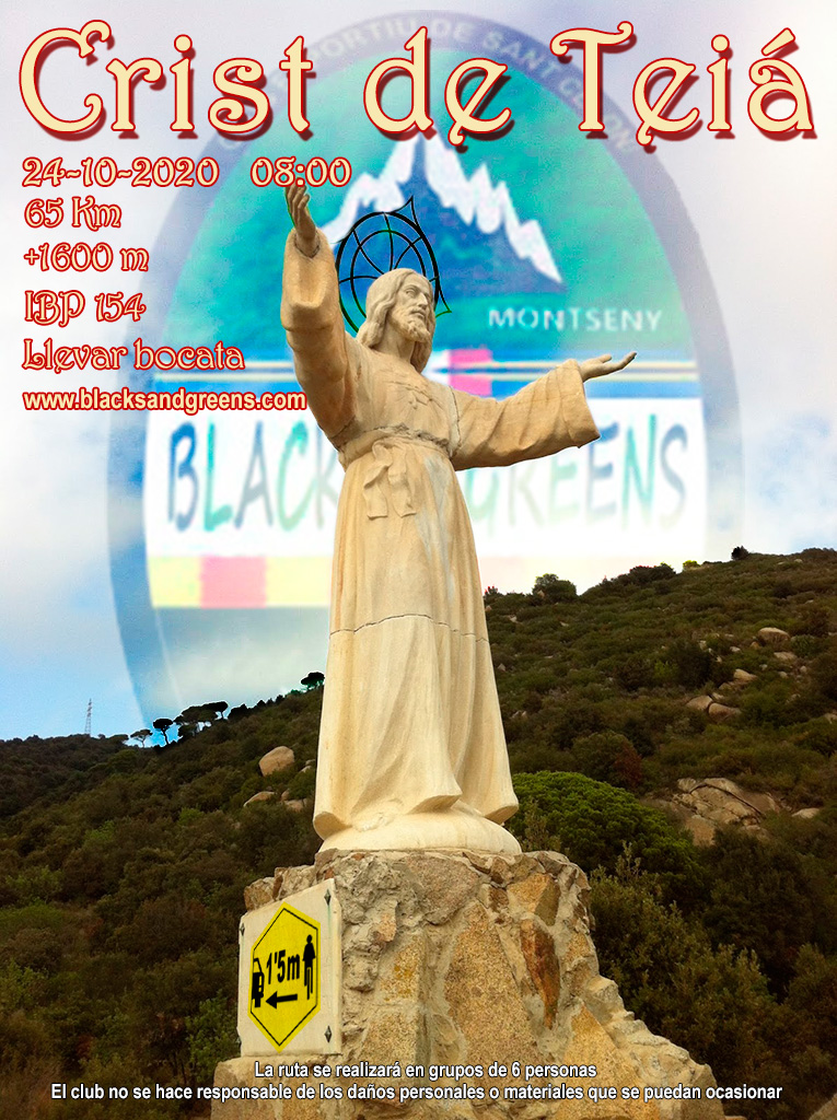
Proyecto Crist de Teiá

MTB
MTB
Ref..: 912502
Published: 19/10/2020
Performed: 19/10/2020
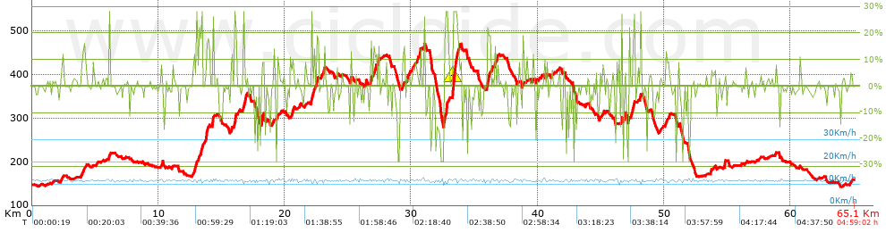
Distance in Km: 65
Climb in m: 1597
IBP: 154 BYC

Guan
Author: Guan
339 published routes

Add to my Group or Club

 Height in m      Climb in %      Speed in Km/h      Speed < 2 Km/h

Climbs > 5%

Climbs >5% Climbs >10% Climbs >15% Climbs >20% Climbs >25%
 Steep slope of 153 m.   Average slope  Distances  Download as waypoint
1
 Km 10.204  9%  153 m
 Steep slope of 327 m.  Average slope  Distances  Download as waypoint
2
 Km 12.746  7%  66 m
3
 Km 12.812  10%  183 m
4
 Km 12.994  13%  78 m
 Steep slope of 146 m.  Average slope  Distances  Download as waypoint
5
 Km 13.409  15%  146 m
 Steep slope of 234 m.  Average slope  Distances  Download as waypoint
6
 Km 13.687  9%  79 m
7
 Km 13.767  15%  155 m
 Steep slope of 119 m.  Average slope  Distances  Download as waypoint
8
 Km 14.279  17%  119 m
 Steep slope of 118 m.  Average slope  Distances  Download as waypoint
9
 Km 15.725  6%  118 m
 Steep slope of 123 m.  Average slope  Distances  Download as waypoint
10
 Km 16.013  18%  123 m
 Steep slope of 198 m.  Average slope  Distances  Download as waypoint
11
 Km 16.739  17%  120 m
12
 Km 16.859  21%  78 m
 Steep slope of 193 m.  Average slope  Distances  Download as waypoint
13
 Km 18.159  14%  193 m
 Steep slope of 121 m.  Average slope  Distances  Download as waypoint
14
 Km 19.091  12%  121 m
 Steep slope of 302 m.  Average slope  Distances  Download as waypoint
15
 Km 20.445  9%  302 m
 Steep slope of 163 m.  Average slope  Distances  Download as waypoint
16
 Km 22.123  16%  163 m
 Steep slope of 153 m.  Average slope  Distances  Download as waypoint
17
 Km 24.085  8%  153 m
 Steep slope of 222 m.  Average slope  Distances  Download as waypoint
18
 Km 27.021  8%  110 m
19
 Km 27.131  11%  112 m
 Steep slope of 132 m.  Average slope  Distances  Download as waypoint
20
 Km 29.283  6%  132 m
 Steep slope of 174 m.  Average slope  Distances  Download as waypoint
21
 Km 29.651  9%  174 m
 Steep slope of 303 m.  Average slope  Distances  Download as waypoint
22
 Km 30.102  5%  303 m
 Steep slope of 211 m.  Average slope  Distances  Download as waypoint
23
 Km 30.462  5%  211 m
 Steep slope of 113 m.  Average slope  Distances  Download as waypoint
24
 Km 32.581  21%  113 m
 Steep slope of 210 m.  Average slope  Distances  Download as waypoint
25
 Km 32.728  20%  64 m
26
 Km 32.792  28%  37 m
27
 Km 32.829  9%  109 m
 Steep slope of 602 m.  Average slope  Distances  Download as waypoint
28
 Km 33.278  28%  302 m
29
 Km 33.58  19%  47 m
30
 Km 33.627  13%  74 m
31
 Km 33.701  16%  54 m
32
 Km 33.755  8%  125 m
 Steep slope of 311 m.  Average slope  Distances  Download as waypoint
33
 Km 35.993  12%  44 m
34
 Km 36.037  13%  198 m
35
 Km 36.235  14%  69 m
 Steep slope of 269 m.  Average slope  Distances  Download as waypoint
36
 Km 36.608  9%  166 m
37
 Km 36.774  11%  103 m
 Steep slope of 147 m.  Average slope  Distances  Download as waypoint
38
 Km 44.871  6%  147 m
 Steep slope of 104 m.  Average slope  Distances  Download as waypoint
39
 Km 45.136  7%  104 m
 Steep slope of 394 m.  Average slope  Distances  Download as waypoint
40
 Km 47.241  10%  138 m
41
 Km 47.379  10%  103 m
42
 Km 47.482  10%  118 m
43
 Km 47.599  11%  35 m
 Steep slope of 270 m.  Average slope  Distances  Download as waypoint
44
 Km 50.088  7%  270 m
 Steep slope of 132 m.  Average slope  Distances  Download as waypoint
45
 Km 54.758  13%  132 m


Description of the route


Presence of ramps


 Climbs  Distance  % of the total  Speed  Your speed would be  Time  Your time would be
   15 - 30%  3.117  4.8  12.59  ?  0:14:51  ?
   10 - 15%  2.666  4.1  12.99  ?  0:12:19  ?
   5 - 10%  4.627  7.12  13.04  ?  0:21:17  ?
   1 - 5%  8.981  13.82  13.07  ?  0:41:14  ?
   Total*  19.39 Km  29.83 %  12.97 Km/h  ? Km/h    1:29:41 h  ? h  
 Flat
   1 - -1%  25.868 Km  39.8 %  13.11 Km/h  ? Km/h    1:58:21 h  ? h  
 Descents
   -1 - -5%  9.618  14.8  13.09  ?  0:44:05  ?
   -5 - -10%  4.797  7.38  13.1  ?  0:21:58  ?
   -10 - -15%  2.187  3.36  12.74  ?  0:10:18  ?
   -15 - -30%  3.245  4.99  12.85  ?  0:15:09  ?
   Total*  19.848 Km  30.54 %  13.01 Km/h  ? Km/h    1:31:30 h  ? h  
* The total has not necessarily coincide with the sum of the partials after correction of errors

How long would it take you?

How long would it take you to cover this route?
There are routes without a valid time information, but with your average stats you can assess the possible duration

Guan to cover this route you've need a time of:   4:59:32 h 
If you sign in and have a minimum of two tracks of this same modality, you can know your time for this route, calculated from your stats..


¿Cuanto consumirá tu E-BIKE?

Entra tu E-IBP (formato n,nn)

E-IBP :   X 154 = 


 Detected activity type =  ()
 Penalization due to track conditions: 78 %   ( > 50 % = MTB, < 50 % = RDB)
 Reliability of the track: C   (1623/52/0/-/-/52)
 Correction level applied to the track: 0
DIFFICULTY OF THE ROUTE
IBP = 154 BYC
According to your statistics
 Your time in motion would be: ? h
Your average speed would be: ? Km/h
 

 Total Distance: 65 Km
 Analysed distance: 65 Km
 Linear distance: 0.28 Km

 Cumulated positive ramps: 1596.55 m  list of points info
 Cumulated negative ramps: 1586.66 m
 Maximum height: 470.6 m
 Minimum height: 142.4 m
 Climbing Ratio: 8.23 %
 Descent ratio: 7.99 %
 Cumulated postive ramps per Km: 24.56 m
 Cumulated negative ramps per Km: 24.41 m

 Total time: 4:59:02 h
 Time in movement: 4:59:32 h
 According to your statistics
 Your time in motion would be: ? h  
 Stopped time: -1:59:30 h
 Maximum slope filter: ~30 %
 Minimum separation analysed: ~30 m
 Number of points: 1937   (cad. 33.56 m)
 Significant waypoints: 1209   (cad. 53.9 m / 62.42 %)

 Changes in direction per Km: 8.68
 Changes in direction > 5º por Km: 7.17
 Cumulated straight stretches: 6.161 Km
 Straight stretches per Km: 94.78 m
 Penalized slope changes: 21
 Penalized slope changes per Km: 0.323

 Average speed in total: 13.04 Km/h
 Average speed while moving: 13.02 Km/h
 According to your statistics
 Your average speed would be: ? Km/h  
 Maximum sustained speed: 14.5 Km/h


Comments

You can be the first one in commenting this route

 
My comments
:
Add comment  (Registered users)
 
Notify me answers to my comment  Do not notify answers to my comment


Share this route with a friend

Your friend will receive a message with a link to this page:
will see your email and your user name if you do it as registered user.


Write here your name (optional)

E-mail address of your friend(s). You can include various addresses separated by commas

Text or comment (optional) maximum 255 characters long, 255 Available characters

As a non registered users you need to fill-in the captcha text.
  Change image
Type the image characters.
 
 Share with a friend


Visited history

Delete history

Marked routes for review later or compare

My favorites


  Notify anomaly in this route Share in Facebook