Barriada Del Angel (Alcolea) (Córdoba)

MTB
MTB
Ref..: 910364
Published: 12/10/2020
Performed: 11/10/2020
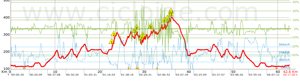
Distance in Km: 62.62
Climb in m: 1264
IBP: 105 BYC

Near ...
Alcolea, Barriada Del Angel (Alcolea), Cansinos, Los, Encinares De Alcolea, Monton De Tierra, Porrillas
Sergio_Hernandez
125 published routes

Add to my Group or Club

 Height in m      Climb in %      Speed in Km/h      Speed < 2 Km/h

Climbs > 5%

Climbs >5% Climbs >10% Climbs >15% Climbs >20% Climbs >25%
 Steep slope of 218 m.   Average slope  Distances  Download as waypoint
1
 Km 5.149  6%  218 m
 Steep slope of 362 m.  Average slope  Distances  Download as waypoint
2
 Km 9.865  6%  362 m
 Steep slope of 122 m.  Average slope  Distances  Download as waypoint
3
 Km 11.391  6%  122 m
 Steep slope of 402 m.  Average slope  Distances  Download as waypoint
4
 Km 13.025  5%  402 m
 Steep slope of 334 m.  Average slope  Distances  Download as waypoint
5
 Km 14.893  6%  334 m
 Steep slope of 248 m.  Average slope  Distances  Download as waypoint
6
 Km 15.443  6%  248 m
 Steep slope of 311 m.  Average slope  Distances  Download as waypoint
7
 Km 21.626  6%  311 m
 Steep slope of 881 m.  Average slope  Distances  Download as waypoint
8
 Km 22.62  7%  38 m
9
 Km 22.658  10%  109 m
10
 Km 22.767  8%  368 m
11
 Km 23.135  11%  213 m
12
 Km 23.348  9%  153 m
 Steep slope of 187 m.  Average slope  Distances  Download as waypoint
13
 Km 23.635  8%  187 m
 Steep slope of 188 m.  Average slope  Distances  Download as waypoint
14
 Km 25.506  6%  188 m
 Steep slope of 455 m.  Average slope  Distances  Download as waypoint
15
 Km 25.871  8%  455 m
 Steep slope of 482 m.  Average slope  Distances  Download as waypoint
16
 Km 26.477  7%  482 m
 Steep slope of 188 m.  Average slope  Distances  Download as waypoint
17
 Km 27.817  8%  66 m
18
 Km 27.883  21%  122 m
 Steep slope of 112 m.  Average slope  Distances  Download as waypoint
19
 Km 28.244  21%  112 m
 Steep slope of 134 m.  Average slope  Distances  Download as waypoint
20
 Km 29.379  7%  33 m
21
 Km 29.413  22%  101 m
 Steep slope of 125 m.  Average slope  Distances  Download as waypoint
22
 Km 29.688  14%  30 m
23
 Km 29.719  10%  95 m
 Steep slope of 236 m.  Average slope  Distances  Download as waypoint
24
 Km 30.261  13%  236 m
 Steep slope of 106 m.  Average slope  Distances  Download as waypoint
25
 Km 30.804  7%  106 m
 Steep slope of 113 m.  Average slope  Distances  Download as waypoint
26
 Km 31.462  12%  113 m
 Steep slope of 269 m.  Average slope  Distances  Download as waypoint
27
 Km 31.811  8%  269 m
 Steep slope of 156 m.  Average slope  Distances  Download as waypoint
28
 Km 32.442  10%  156 m
 Steep slope of 127 m.  Average slope  Distances  Download as waypoint
29
 Km 32.85  5%  127 m
 Steep slope of 101 m.  Average slope  Distances  Download as waypoint
30
 Km 33.097  15%  101 m
 Steep slope of 294 m.  Average slope  Distances  Download as waypoint
31
 Km 33.585  5%  294 m
 Steep slope of 153 m.  Average slope  Distances  Download as waypoint
32
 Km 34.461  20%  105 m
33
 Km 34.566  10%  48 m
 Steep slope of 233 m.  Average slope  Distances  Download as waypoint
34
 Km 34.778  9%  233 m
 Steep slope of 181 m.  Average slope  Distances  Download as waypoint
35
 Km 35.123  16%  181 m
 Steep slope of 170 m.  Average slope  Distances  Download as waypoint
36
 Km 35.858  17%  96 m
37
 Km 35.955  13%  74 m
 Steep slope of 112 m.  Average slope  Distances  Download as waypoint
38
 Km 40.262  9%  112 m
 Steep slope of 488 m.  Average slope  Distances  Download as waypoint
39
 Km 44.947  7%  488 m
 Steep slope of 197 m.  Average slope  Distances  Download as waypoint
40
 Km 47.447  6%  197 m
 Steep slope of 423 m.  Average slope  Distances  Download as waypoint
41
 Km 47.981  8%  423 m
 Steep slope of 154 m.  Average slope  Distances  Download as waypoint
42
 Km 50.345  6%  154 m
 Steep slope of 480 m.  Average slope  Distances  Download as waypoint
43
 Km 51.61  8%  480 m
 Steep slope of 188 m.  Average slope  Distances  Download as waypoint
44
 Km 55.774  5%  188 m
 Steep slope of 102 m.  Average slope  Distances  Download as waypoint
45
 Km 61.511  6%  102 m


Description of the route


Presence of ramps


 Climbs  Distance  % of the total  Speed  Your speed would be  Time  Your time would be
   15 - 30%  1.381  2.2  10.85  ?  0:07:38  ?
   10 - 15%  1.185  1.89  10.69  ?  0:06:39  ?
   5 - 10%  7.541  12.04  12.02  ?  0:37:38  ?
   1 - 5%  10.828  17.29  14.75  ?  0:44:03  ?
   Total*  20.934 Km  33.43 %  13.09 Km/h  ? Km/h    1:35:58 h  ? h  
 Flat
   1 - -1%  18.917 Km  30.21 %  19.79 Km/h  ? Km/h    0:57:21 h  ? h  
 Descents
   -1 - -5%  12.554  20.05  25.02  ?  0:30:06  ?
   -5 - -10%  8.025  12.81  21.75  ?  0:22:08  ?
   -10 - -15%  0.995  1.59  14.57  ?  0:04:06  ?
   -15 - -30%  1.207  1.93  14.58  ?  0:04:58  ?
   Total*  22.781 Km  36.38 %  22.3 Km/h  ? Km/h    1:01:18 h  ? h  
* The total has not necessarily coincide with the sum of the partials after correction of errors

How long would it take you?

How long would it take you to cover this route?
There are routes without a valid time information, but with your average stats you can assess the possible duration

Sergio_Hernandez to cover this route you've need a time of:   3:34:37 h 
If you sign in and have a minimum of two tracks of this same modality, you can know your time for this route, calculated from your stats..


¿Cuanto consumirá tu E-BIKE?

Entra tu E-IBP (formato n,nn)

E-IBP :   X 105 = 


 Detected activity type =  ()
 Penalization due to track conditions: 71 %   ( > 50 % = MTB, < 50 % = RDB)
 Reliability of the track: C   (1270/55/0/-/-/55)
 Correction level applied to the track: 0
DIFFICULTY OF THE ROUTE
IBP = 105 BYC
According to your statistics
 Your time in motion would be: ? h
Your average speed would be: ? Km/h
 

 Total Distance: 62.62 Km
 Analysed distance: 62.62 Km
 Linear distance: 0 Km

 Cumulated positive ramps: 1264.1 m  list of points info
 Cumulated negative ramps: 1266.2 m
 Maximum height: 402.8 m
 Minimum height: 112 m
 Climbing Ratio: 6.04 %
 Descent ratio: 5.56 %
 Cumulated postive ramps per Km: 20.19 m
 Cumulated negative ramps per Km: 20.22 m

 Total time: 5:17:28 h
 Time in movement: 3:34:37 h
 According to your statistics
 Your time in motion would be: ? h  
 Stopped time: 1:42:51 h
 Maximum slope filter: ~30 %
 Minimum separation analysed: ~30 m
 Number of points: 2787   (cad. 22.47 m)
 Significant waypoints: 1429   (cad. 43.85 m / 51.27 %)

 Changes in direction per Km: 9.01
 Changes in direction > 5º por Km: 6.83
 Cumulated straight stretches: 13.156 Km
 Straight stretches per Km: 210.09 m
 Penalized slope changes: 12
 Penalized slope changes per Km: 0.192

 Average speed in total: 11.84 Km/h
 Average speed while moving: 17.51 Km/h
 According to your statistics
 Your average speed would be: ? Km/h  
 Maximum sustained speed: 53.98 Km/h


Comments

You can be the first one in commenting this route

 
My comments
:
Add comment  (Registered users)
 
Notify me answers to my comment  Do not notify answers to my comment


Share this route with a friend

Your friend will receive a message with a link to this page:
will see your email and your user name if you do it as registered user.


Write here your name (optional)

E-mail address of your friend(s). You can include various addresses separated by commas

Text or comment (optional) maximum 255 characters long, 255 Available characters

As a non registered users you need to fill-in the captcha text.
  Change image
Type the image characters.
 
 Share with a friend


Visited history

Delete history

Marked routes for review later or compare

My favorites


  Notify anomaly in this route Share in Facebook