Beniajan (Murcia)

MTB
MTB
Ref..: 908130
Published: 03/10/2020
Performed: 03/10/2020
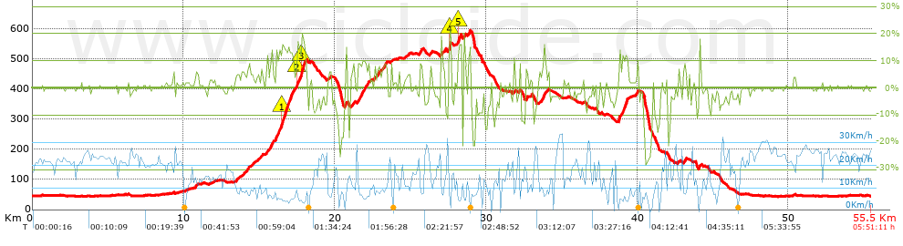
Distance in Km: 55.52
Climb in m: 1136
IBP: 102 BYC

Near ...
Azarbe (Parroquia), Barrio De La Aurora, Beniajan, Bojal, El, Canute, Casas Nuevas (Beniajan)
CAMPELLO64
Author: CAMPELLO64
394 published routes

Add to my Group or Club

 Height in m      Climb in %      Speed in Km/h      Speed < 2 Km/h

Climbs > 5%

Climbs >5% Climbs >10% Climbs >15% Climbs >20% Climbs >25%
 Steep slope of 542 m.   Average slope  Distances  Download as waypoint
1
 Km 13.839  6%  542 m
 Steep slope of 315 m.  Average slope  Distances  Download as waypoint
2
 Km 14.861  5%  315 m
 Steep slope of 501 m.  Average slope  Distances  Download as waypoint
3
 Km 15.445  8%  501 m
 Steep slope of 1963 m.  Average slope  Distances  Download as waypoint
4
 Km 16.055  6%  44 m
5
 Km 16.099  13%  155 m
6
 Km 16.254  8%  93 m
7
 Km 16.347  14%  144 m
8
 Km 16.49  17%  263 m
9
 Km 16.754  13%  515 m
10
 Km 17.269  7%  250 m
11
 Km 17.519  17%  134 m
12
 Km 17.653  10%  107 m
13
 Km 17.76  17%  220 m
14
 Km 17.98  18%  38 m
 Steep slope of 117 m.  Average slope  Distances  Download as waypoint
15
 Km 19.617  5%  117 m
 Steep slope of 146 m.  Average slope  Distances  Download as waypoint
16
 Km 20.658  12%  146 m
 Steep slope of 174 m.  Average slope  Distances  Download as waypoint
17
 Km 21.142  8%  174 m
 Steep slope of 783 m.  Average slope  Distances  Download as waypoint
18
 Km 21.478  9%  369 m
19
 Km 21.847  10%  114 m
20
 Km 21.961  9%  300 m
 Steep slope of 102 m.  Average slope  Distances  Download as waypoint
21
 Km 22.554  8%  102 m
 Steep slope of 217 m.  Average slope  Distances  Download as waypoint
22
 Km 22.774  6%  217 m
 Steep slope of 368 m.  Average slope  Distances  Download as waypoint
23
 Km 23.114  8%  368 m
 Steep slope of 96 m.  Average slope  Distances  Download as waypoint
24
 Km 23.715  8%  96 m
 Steep slope of 220 m.  Average slope  Distances  Download as waypoint
25
 Km 25.609  8%  220 m
 Steep slope of 160 m.  Average slope  Distances  Download as waypoint
26
 Km 26.289  7%  160 m
 Steep slope of 258 m.  Average slope  Distances  Download as waypoint
27
 Km 27.02  7%  258 m
 Steep slope of 142 m.  Average slope  Distances  Download as waypoint
28
 Km 27.531  20%  142 m
 Steep slope of 247 m.  Average slope  Distances  Download as waypoint
29
 Km 28.105  5%  32 m
30
 Km 28.137  11%  70 m
31
 Km 28.206  16%  107 m
32
 Km 28.314  16%  38 m
 Steep slope of 108 m.  Average slope  Distances  Download as waypoint
33
 Km 28.549  15%  108 m
 Steep slope of 177 m.  Average slope  Distances  Download as waypoint
34
 Km 28.814  13%  142 m
35
 Km 28.956  5%  35 m
 Steep slope of 118 m.  Average slope  Distances  Download as waypoint
36
 Km 31.821  7%  118 m
 Steep slope of 135 m.  Average slope  Distances  Download as waypoint
37
 Km 32.637  10%  135 m
 Steep slope of 392 m.  Average slope  Distances  Download as waypoint
38
 Km 33.524  6%  289 m
39
 Km 33.813  15%  103 m
 Steep slope of 624 m.  Average slope  Distances  Download as waypoint
40
 Km 38.764  15%  115 m
41
 Km 38.879  5%  108 m
42
 Km 38.986  13%  323 m
43
 Km 39.31  13%  78 m
 Steep slope of 133 m.  Average slope  Distances  Download as waypoint
44
 Km 39.862  5%  133 m
 Steep slope of 197 m.  Average slope  Distances  Download as waypoint
45
 Km 43.042  8%  197 m
 Steep slope of 110 m.  Average slope  Distances  Download as waypoint
46
 Km 44.074  11%  110 m


Description of the route


Presence of ramps


 Climbs  Distance  % of the total  Speed  Your speed would be  Time  Your time would be
   15 - 30%  1.4  2.52  5.74  ?  0:14:38  ?
   10 - 15%  2.034  3.66  6.32  ?  0:19:18  ?
   5 - 10%  5.783  10.42  9.14  ?  0:37:57  ?
   1 - 5%  8.728  15.72  12.14  ?  0:43:09  ?
   Total*  17.945 Km  32.32 %  9.36 Km/h  ? Km/h    1:55:02 h  ? h  
 Flat
   1 - -1%  20.359 Km  36.67 %  20.76 Km/h  ? Km/h    0:58:51 h  ? h  
 Descents
   -1 - -5%  8.921  16.07  16.28  ?  0:32:53  ?
   -5 - -10%  5.011  9.03  13.82  ?  0:21:45  ?
   -10 - -15%  1.609  2.9  13.2  ?  0:07:19  ?
   -15 - -30%  1.678  3.02  8.38  ?  0:12:01  ?
   Total*  17.22 Km  31.01 %  13.97 Km/h  ? Km/h    1:13:58 h  ? h  
* The total has not necessarily coincide with the sum of the partials after correction of errors

How long would it take you?

How long would it take you to cover this route?
There are routes without a valid time information, but with your average stats you can assess the possible duration

CAMPELLO64 to cover this route you've need a time of:   4:07:51 h 
If you sign in and have a minimum of two tracks of this same modality, you can know your time for this route, calculated from your stats..


¿Cuanto consumirá tu E-BIKE?

Entra tu E-IBP (formato n,nn)

E-IBP :   X 102 = 


 Detected activity type =  ()
 Penalization due to track conditions: 68 %   ( > 50 % = MTB, < 50 % = RDB)
 Reliability of the track: C   (1136/56/0/-/-/56)
 Correction level applied to the track: 0
DIFFICULTY OF THE ROUTE
IBP = 102 BYC
According to your statistics
 Your time in motion would be: ? h
Your average speed would be: ? Km/h
 

 Total Distance: 55.52 Km
 Analysed distance: 55.52 Km
 Linear distance: 0.77 Km

 Cumulated positive ramps: 1136 m  list of points info
 Cumulated negative ramps: 1148.1 m
 Maximum height: 595.3 m
 Minimum height: 43.3 m
 Climbing Ratio: 6.33 %
 Descent ratio: 6.67 %
 Cumulated postive ramps per Km: 20.46 m
 Cumulated negative ramps per Km: 20.68 m

 Total time: 5:51:11 h
 Time in movement: 4:07:51 h
 According to your statistics
 Your time in motion would be: ? h  
 Stopped time: 1:43:20 h
 Maximum slope filter: ~30 %
 Minimum separation analysed: ~30 m
 Number of points: 2865   (cad. 19.38 m)
 Significant waypoints: 1343   (cad. 41.34 m / 46.88 %)

 Changes in direction per Km: 10.37
 Changes in direction > 5º por Km: 6.77
 Cumulated straight stretches: 16.333 Km
 Straight stretches per Km: 294.18 m
 Penalized slope changes: 12
 Penalized slope changes per Km: 0.216

 Average speed in total: 9.49 Km/h
 Average speed while moving: 13.44 Km/h
 According to your statistics
 Your average speed would be: ? Km/h  
 Maximum sustained speed: 35.97 Km/h


Comments

You can be the first one in commenting this route

 
My comments
:
Add comment  (Registered users)
 
Notify me answers to my comment  Do not notify answers to my comment


Share this route with a friend

Your friend will receive a message with a link to this page:
will see your email and your user name if you do it as registered user.


Write here your name (optional)

E-mail address of your friend(s). You can include various addresses separated by commas

Text or comment (optional) maximum 255 characters long, 255 Available characters

As a non registered users you need to fill-in the captcha text.
  Change image
Type the image characters.
 
 Share with a friend


Visited history

Delete history

Marked routes for review later or compare

My favorites


  Notify anomaly in this route Share in Facebook