Alberca, La (Murcia)

MTB
MTB
Ref..: 906791
Published: 27/09/2020
Performed: 27/09/2020
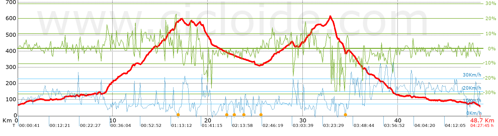
Distance in Km: 48.75
Climb in m: 1144
IBP: 89 BYC

Near ...
Alberca, La, Aljucer, Barrio La Victoria, Era Alta, Maurillos, Los (Carril), Murcia
CAMPELLO64
Author: CAMPELLO64
394 published routes

Add to my Group or Club

 Height in m      Climb in %      Speed in Km/h      Speed < 2 Km/h

Climbs > 5%

Climbs >5% Climbs >10% Climbs >15% Climbs >20% Climbs >25%
 Steep slope of 125 m.   Average slope  Distances  Download as waypoint
1
 Km 4.893  8%  125 m
 Steep slope of 143 m.  Average slope  Distances  Download as waypoint
2
 Km 6.443  7%  143 m
 Steep slope of 152 m.  Average slope  Distances  Download as waypoint
3
 Km 8.374  8%  152 m
 Steep slope of 335 m.  Average slope  Distances  Download as waypoint
4
 Km 9.272  13%  235 m
5
 Km 9.507  8%  100 m
 Steep slope of 113 m.  Average slope  Distances  Download as waypoint
6
 Km 9.76  9%  113 m
 Steep slope of 96 m.  Average slope  Distances  Download as waypoint
7
 Km 9.985  8%  96 m
 Steep slope of 199 m.  Average slope  Distances  Download as waypoint
8
 Km 10.3  5%  49 m
9
 Km 10.349  9%  104 m
10
 Km 10.453  5%  46 m
 Steep slope of 184 m.  Average slope  Distances  Download as waypoint
11
 Km 10.78  5%  184 m
 Steep slope of 144 m.  Average slope  Distances  Download as waypoint
12
 Km 11.397  5%  144 m
 Steep slope of 365 m.  Average slope  Distances  Download as waypoint
13
 Km 11.745  8%  117 m
14
 Km 11.862  11%  177 m
15
 Km 12.038  13%  71 m
 Steep slope of 666 m.  Average slope  Distances  Download as waypoint
16
 Km 12.925  8%  408 m
17
 Km 13.333  10%  102 m
18
 Km 13.435  9%  156 m
 Steep slope of 703 m.  Average slope  Distances  Download as waypoint
19
 Km 13.687  7%  703 m
 Steep slope of 221 m.  Average slope  Distances  Download as waypoint
20
 Km 14.88  8%  221 m
 Steep slope of 121 m.  Average slope  Distances  Download as waypoint
21
 Km 15.215  10%  121 m
 Steep slope of 341 m.  Average slope  Distances  Download as waypoint
22
 Km 15.492  13%  43 m
23
 Km 15.534  14%  143 m
24
 Km 15.677  17%  78 m
25
 Km 15.755  10%  77 m
 Steep slope of 211 m.  Average slope  Distances  Download as waypoint
26
 Km 15.97  8%  211 m
 Steep slope of 319 m.  Average slope  Distances  Download as waypoint
27
 Km 16.4  9%  41 m
28
 Km 16.44  13%  74 m
29
 Km 16.514  24%  143 m
30
 Km 16.657  13%  61 m
 Steep slope of 126 m.  Average slope  Distances  Download as waypoint
31
 Km 17.08  7%  126 m
 Steep slope of 226 m.  Average slope  Distances  Download as waypoint
32
 Km 18.011  9%  35 m
33
 Km 18.046  15%  150 m
34
 Km 18.196  6%  41 m
 Steep slope of 200 m.  Average slope  Distances  Download as waypoint
35
 Km 18.84  8%  200 m
 Steep slope of 114 m.  Average slope  Distances  Download as waypoint
36
 Km 25.727  7%  114 m
 Steep slope of 513 m.  Average slope  Distances  Download as waypoint
37
 Km 26.388  6%  360 m
38
 Km 26.749  12%  107 m
39
 Km 26.856  10%  46 m
 Steep slope of 113 m.  Average slope  Distances  Download as waypoint
40
 Km 27.906  6%  113 m
 Steep slope of 210 m.  Average slope  Distances  Download as waypoint
41
 Km 28.604  8%  210 m
 Steep slope of 284 m.  Average slope  Distances  Download as waypoint
42
 Km 29.583  6%  73 m
43
 Km 29.656  10%  143 m
44
 Km 29.799  11%  68 m
 Steep slope of 434 m.  Average slope  Distances  Download as waypoint
45
 Km 30.11  7%  39 m
46
 Km 30.149  16%  148 m
47
 Km 30.297  7%  247 m
 Steep slope of 263 m.  Average slope  Distances  Download as waypoint
48
 Km 30.709  13%  263 m
 Steep slope of 277 m.  Average slope  Distances  Download as waypoint
49
 Km 31.158  8%  277 m
 Steep slope of 515 m.  Average slope  Distances  Download as waypoint
50
 Km 32.366  9%  294 m
51
 Km 32.66  11%  105 m
52
 Km 32.765  13%  116 m
 Steep slope of 253 m.  Average slope  Distances  Download as waypoint
53
 Km 34.527  8%  253 m


Description of the route


Presence of ramps


 Climbs  Distance  % of the total  Speed  Your speed would be  Time  Your time would be
   15 - 30%  0.726  1.49  6.27  ?  0:06:57  ?
   10 - 15%  2.118  4.35  7.75  ?  0:16:24  ?
   5 - 10%  6.343  13.01  9.44  ?  0:40:19  ?
   1 - 5%  10.893  22.35  13.59  ?  0:48:05  ?
   Total*  20.081 Km  41.19 %  10.78 Km/h  ? Km/h    1:51:45 h  ? h  
 Flat
   1 - -1%  8.631 Km  17.71 %  16.17 Km/h  ? Km/h    0:32:01 h  ? h  
 Descents
   -1 - -5%  12.31  25.25  14.45  ?  0:51:06  ?
   -5 - -10%  4.85  9.95  19.64  ?  0:14:49  ?
   -10 - -15%  1.254  2.57  15.51  ?  0:04:51  ?
   -15 - -30%  1.62  3.32  10.2  ?  0:09:32  ?
   Total*  20.034 Km  41.1 %  14.97 Km/h  ? Km/h    1:20:18 h  ? h  
* The total has not necessarily coincide with the sum of the partials after correction of errors

How long would it take you?

How long would it take you to cover this route?
There are routes without a valid time information, but with your average stats you can assess the possible duration

CAMPELLO64 to cover this route you've need a time of:   3:44:04 h 
If you sign in and have a minimum of two tracks of this same modality, you can know your time for this route, calculated from your stats..


¿Cuanto consumirá tu E-BIKE?

Entra tu E-IBP (formato n,nn)

E-IBP :   X 89 = 


 Detected activity type =  ()
 Penalization due to track conditions: 72 %   ( > 50 % = MTB, < 50 % = RDB)
 Reliability of the track: C   (1144/56/0/-/-/56)
 Correction level applied to the track: 0
DIFFICULTY OF THE ROUTE
IBP = 89 BYC
According to your statistics
 Your time in motion would be: ? h
Your average speed would be: ? Km/h
 

 Total Distance: 48.75 Km
 Analysed distance: 48.75 Km
 Linear distance: 0.84 Km

 Cumulated positive ramps: 1144 m  list of points info
 Cumulated negative ramps: 1152.8 m
 Maximum height: 614 m
 Minimum height: 56.8 m
 Climbing Ratio: 5.7 %
 Descent ratio: 5.75 %
 Cumulated postive ramps per Km: 23.47 m
 Cumulated negative ramps per Km: 23.65 m

 Total time: 4:27:45 h
 Time in movement: 3:44:04 h
 According to your statistics
 Your time in motion would be: ? h  
 Stopped time: 0:43:41 h
 Maximum slope filter: ~30 %
 Minimum separation analysed: ~30 m
 Number of points: 2536   (cad. 19.22 m)
 Significant waypoints: 1219   (cad. 39.99 m / 48.07 %)

 Changes in direction per Km: 11.57
 Changes in direction > 5º por Km: 8.45
 Cumulated straight stretches: 10.242 Km
 Straight stretches per Km: 210.09 m
 Penalized slope changes: 7
 Penalized slope changes per Km: 0.144

 Average speed in total: 10.92 Km/h
 Average speed while moving: 13.05 Km/h
 According to your statistics
 Your average speed would be: ? Km/h  
 Maximum sustained speed: 45.63 Km/h


Comments

You can be the first one in commenting this route

 
My comments
:
Add comment  (Registered users)
 
Notify me answers to my comment  Do not notify answers to my comment


Share this route with a friend

Your friend will receive a message with a link to this page:
will see your email and your user name if you do it as registered user.


Write here your name (optional)

E-mail address of your friend(s). You can include various addresses separated by commas

Text or comment (optional) maximum 255 characters long, 255 Available characters

As a non registered users you need to fill-in the captcha text.
  Change image
Type the image characters.
 
 Share with a friend


Visited history

Delete history

Marked routes for review later or compare

My favorites


  Notify anomaly in this route Share in Facebook