O Castrove cos ___

MTB
MTB
Ref..: 906679
Published: 27/09/2020
Performed: 27/09/2020
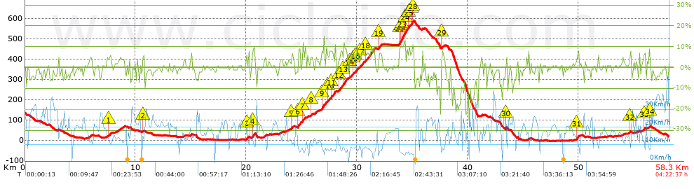
Distance in Km: 58.32
Climb in m: 937
IBP: 62 BYC

Near ...
Acevedo (Ponte Sampaio), Aranza (Soutomaior), Arcade (Santiago), Bretoña (Curro), Calle, A (Arcade), Canicouva, A (Santo Estevo)
Javier Durán
299 published routes

Add to my Group or Club

 Height in m      Climb in %      Speed in Km/h      Speed < 2 Km/h

Climbs > 5%

Climbs >5% Climbs >10% Climbs >15% Climbs >20% Climbs >25%
 Steep slope of 202 m.   Average slope  Distances  Download as waypoint
1
 Km 7.597  5%  202 m
 Steep slope of 141 m.  Average slope  Distances  Download as waypoint
2
 Km 10.645  5%  141 m
 Steep slope of 185 m.  Average slope  Distances  Download as waypoint
3
 Km 20.033  5%  185 m
 Steep slope of 290 m.  Average slope  Distances  Download as waypoint
4
 Km 20.541  8%  290 m
 Steep slope of 135 m.  Average slope  Distances  Download as waypoint
5
 Km 24.081  8%  135 m
 Steep slope of 299 m.  Average slope  Distances  Download as waypoint
6
 Km 24.651  9%  299 m
 Steep slope of 196 m.  Average slope  Distances  Download as waypoint
7
 Km 25.085  7%  196 m
 Steep slope of 104 m.  Average slope  Distances  Download as waypoint
8
 Km 25.841  6%  104 m
 Steep slope of 361 m.  Average slope  Distances  Download as waypoint
9
 Km 26.847  8%  361 m
 Steep slope of 167 m.  Average slope  Distances  Download as waypoint
10
 Km 27.343  5%  167 m
 Steep slope of 438 m.  Average slope  Distances  Download as waypoint
11
 Km 27.642  8%  438 m
 Steep slope of 304 m.  Average slope  Distances  Download as waypoint
12
 Km 28.36  7%  304 m
 Steep slope of 403 m.  Average slope  Distances  Download as waypoint
13
 Km 28.762  8%  403 m
 Steep slope of 164 m.  Average slope  Distances  Download as waypoint
14
 Km 29.368  6%  164 m
 Steep slope of 167 m.  Average slope  Distances  Download as waypoint
15
 Km 29.63  6%  167 m
 Steep slope of 274 m.  Average slope  Distances  Download as waypoint
16
 Km 29.899  6%  274 m
 Steep slope of 296 m.  Average slope  Distances  Download as waypoint
17
 Km 30.314  6%  296 m
 Steep slope of 898 m.  Average slope  Distances  Download as waypoint
18
 Km 30.716  7%  898 m
 Steep slope of 300 m.  Average slope  Distances  Download as waypoint
19
 Km 31.957  6%  300 m
 Steep slope of 712 m.  Average slope  Distances  Download as waypoint
20
 Km 33.836  9%  32 m
21
 Km 33.868  10%  100 m
22
 Km 33.968  10%  98 m
23
 Km 34.066  11%  321 m
24
 Km 34.387  8%  161 m
 Steep slope of 195 m.  Average slope  Distances  Download as waypoint
25
 Km 34.646  8%  195 m
 Steep slope of 228 m.  Average slope  Distances  Download as waypoint
26
 Km 34.935  8%  32 m
27
 Km 34.967  10%  132 m
28
 Km 35.099  8%  64 m
 Steep slope of 100 m.  Average slope  Distances  Download as waypoint
29
 Km 37.693  7%  100 m
 Steep slope of 102 m.  Average slope  Distances  Download as waypoint
30
 Km 43.474  10%  102 m
 Steep slope of 203 m.  Average slope  Distances  Download as waypoint
31
 Km 49.907  7%  203 m
 Steep slope of 101 m.  Average slope  Distances  Download as waypoint
32
 Km 54.67  7%  101 m
 Steep slope of 139 m.  Average slope  Distances  Download as waypoint
33
 Km 55.929  8%  139 m
 Steep slope of 100 m.  Average slope  Distances  Download as waypoint
34
 Km 56.419  9%  100 m


Description of the route


Presence of ramps


 Climbs  Distance  % of the total  Speed  Your speed would be  Time  Your time would be
   15 - 30%  0  0  0  ?  0:00:00  ?
   10 - 15%  1.308  2.24  6.48  ?  0:12:07  ?
   5 - 10%  6.909  11.85  9.02  ?  0:45:57  ?
   1 - 5%  11.974  20.53  12.69  ?  0:56:38  ?
   Total*  20.191 Km  34.62 %  10.56 Km/h  ? Km/h    1:54:42 h  ? h  
 Flat
   1 - -1%  17.715 Km  30.38 %  17.37 Km/h  ? Km/h    1:01:12 h  ? h  
 Descents
   -1 - -5%  12.966  22.23  20.77  ?  0:37:27  ?
   -5 - -10%  4.897  8.4  21.17  ?  0:13:53  ?
   -10 - -15%  1.675  2.87  14.78  ?  0:06:48  ?
   -15 - -30%  0.873  1.5  13.6  ?  0:03:51  ?
   Total*  20.412 Km  35 %  19.76 Km/h  ? Km/h    1:01:59 h  ? h  
* The total has not necessarily coincide with the sum of the partials after correction of errors

How long would it take you?

How long would it take you to cover this route?
There are routes without a valid time information, but with your average stats you can assess the possible duration

Javier Durán to cover this route you've need a time of:   3:57:53 h 
If you sign in and have a minimum of two tracks of this same modality, you can know your time for this route, calculated from your stats..


¿Cuanto consumirá tu E-BIKE?

Entra tu E-IBP (formato n,nn)

E-IBP :   X 62 = 


 Detected activity type =  ()
 Penalization due to track conditions: 53 %   ( > 50 % = MTB, < 50 % = RDB)
 Reliability of the track: C   (937/56/0/-/-/56)
 Correction level applied to the track: 0
DIFFICULTY OF THE ROUTE
IBP = 62 BYC
According to your statistics
 Your time in motion would be: ? h
Your average speed would be: ? Km/h
 

 Total Distance: 58.32 Km
 Analysed distance: 58.32 Km
 Linear distance: 5.89 Km

 Cumulated positive ramps: 937 m  list of points info
 Cumulated negative ramps: 1053.2 m
 Maximum height: 590.2 m
 Minimum height: -2.2 m
 Climbing Ratio: 4.64 %
 Descent ratio: 5.16 %
 Cumulated postive ramps per Km: 16.07 m
 Cumulated negative ramps per Km: 18.06 m

 Total time: 4:22:37 h
 Time in movement: 3:57:53 h
 According to your statistics
 Your time in motion would be: ? h  
 Stopped time: 0:24:44 h
 Maximum slope filter: ~30 %
 Minimum separation analysed: ~30 m
 Number of points: 4690   (cad. 12.43 m)
 Significant waypoints: 1644   (cad. 35.47 m / 35.05 %)

 Changes in direction per Km: 11.2
 Changes in direction > 5º por Km: 5.85
 Cumulated straight stretches: 18.744 Km
 Straight stretches per Km: 321.4 m
 Penalized slope changes: 8
 Penalized slope changes per Km: 0.137

 Average speed in total: 13.32 Km/h
 Average speed while moving: 14.71 Km/h
 According to your statistics
 Your average speed would be: ? Km/h  
 Maximum sustained speed: 40.79 Km/h


Comments

You can be the first one in commenting this route

 
My comments
:
Add comment  (Registered users)
 
Notify me answers to my comment  Do not notify answers to my comment


Share this route with a friend

Your friend will receive a message with a link to this page:
will see your email and your user name if you do it as registered user.


Write here your name (optional)

E-mail address of your friend(s). You can include various addresses separated by commas

Text or comment (optional) maximum 255 characters long, 255 Available characters

As a non registered users you need to fill-in the captcha text.
  Change image
Type the image characters.
 
 Share with a friend


Visited history

Delete history

Marked routes for review later or compare

My favorites


  Notify anomaly in this route Share in Facebook