2020 09 26 toconcolladoalguacil

MTB
MTB
Ref..: 906480
Published: 27/09/2020
Performed: 26/09/2020
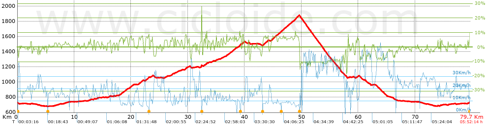
Distance in Km: 79.69
Climb in m: 1521
IBP: 95 BYC


 Height in m      Climb in %      Speed in Km/h      Speed < 2 Km/h

Climbs > 5%

Climbs >5% Climbs >10% Climbs >15% Climbs >20% Climbs >25%
 Steep slope of 471 m.   Average slope  Distances  Download as waypoint
1
 Km 18.082  6%  471 m
 Steep slope of 705 m.  Average slope  Distances  Download as waypoint
2
 Km 18.663  6%  705 m
 Steep slope of 696 m.  Average slope  Distances  Download as waypoint
3
 Km 19.697  6%  696 m
 Steep slope of 719 m.  Average slope  Distances  Download as waypoint
4
 Km 21.377  7%  719 m
 Steep slope of 635 m.  Average slope  Distances  Download as waypoint
5
 Km 22.573  7%  635 m
 Steep slope of 111 m.  Average slope  Distances  Download as waypoint
6
 Km 23.703  6%  111 m
 Steep slope of 107 m.  Average slope  Distances  Download as waypoint
7
 Km 26.223  5%  107 m
 Steep slope of 279 m.  Average slope  Distances  Download as waypoint
8
 Km 27.154  6%  279 m
 Steep slope of 151 m.  Average slope  Distances  Download as waypoint
9
 Km 27.656  6%  151 m
 Steep slope of 175 m.  Average slope  Distances  Download as waypoint
10
 Km 28.069  5%  175 m
 Steep slope of 355 m.  Average slope  Distances  Download as waypoint
11
 Km 29.505  8%  355 m
 Steep slope of 150 m.  Average slope  Distances  Download as waypoint
12
 Km 32.285  5%  75 m
13
 Km 32.36  14%  75 m
 Steep slope of 152 m.  Average slope  Distances  Download as waypoint
14
 Km 32.818  7%  152 m
 Steep slope of 294 m.  Average slope  Distances  Download as waypoint
15
 Km 33.107  8%  294 m
 Steep slope of 113 m.  Average slope  Distances  Download as waypoint
16
 Km 34.989  6%  113 m
 Steep slope of 165 m.  Average slope  Distances  Download as waypoint
17
 Km 35.787  5%  165 m
 Steep slope of 152 m.  Average slope  Distances  Download as waypoint
18
 Km 36.797  9%  152 m
 Steep slope of 153 m.  Average slope  Distances  Download as waypoint
19
 Km 37.091  5%  153 m
 Steep slope of 679 m.  Average slope  Distances  Download as waypoint
20
 Km 37.361  6%  679 m
 Steep slope of 368 m.  Average slope  Distances  Download as waypoint
21
 Km 38.184  6%  368 m
 Steep slope of 576 m.  Average slope  Distances  Download as waypoint
22
 Km 38.728  7%  576 m
 Steep slope of 282 m.  Average slope  Distances  Download as waypoint
23
 Km 39.552  8%  282 m
 Steep slope of 112 m.  Average slope  Distances  Download as waypoint
24
 Km 40.675  5%  112 m
 Steep slope of 938 m.  Average slope  Distances  Download as waypoint
25
 Km 43.204  7%  938 m
 Steep slope of 991 m.  Average slope  Distances  Download as waypoint
26
 Km 44.735  7%  991 m
 Steep slope of 3775 m.  Average slope  Distances  Download as waypoint
27
 Km 45.865  7%  3775 m
 Steep slope of 104 m.  Average slope  Distances  Download as waypoint
28
 Km 59.622  5%  104 m
 Steep slope of 191 m.  Average slope  Distances  Download as waypoint
29
 Km 59.85  5%  191 m
 Steep slope of 107 m.  Average slope  Distances  Download as waypoint
30
 Km 74.44  7%  107 m


Description of the route


Presence of ramps


 Climbs  Distance  % of the total  Speed  Your speed would be  Time  Your time would be
   15 - 30%  0.078  0.1  12.71  ?  0:00:22  ?
   10 - 15%  0.178  0.22  10.19  ?  0:01:03  ?
   5 - 10%  14.389  18.06  9.63  ?  1:29:38  ?
   1 - 5%  19.525  24.5  15.2  ?  1:17:03  ?
   Total*  34.17 Km  42.88 %  12.2 Km/h  ? Km/h    2:48:06 h  ? h  
 Flat
   1 - -1%  17.962 Km  22.54 %  20.25 Km/h  ? Km/h    0:53:14 h  ? h  
 Descents
   -1 - -5%  14.118  17.72  25.77  ?  0:32:52  ?
   -5 - -10%  8.948  11.23  36.77  ?  0:14:36  ?
   -10 - -15%  4.243  5.32  32.99  ?  0:07:43  ?
   -15 - -30%  0.245  0.31  29.45  ?  0:00:30  ?
   Total*  27.555 Km  34.58 %  29.69 Km/h  ? Km/h    0:55:41 h  ? h  
* The total has not necessarily coincide with the sum of the partials after correction of errors

How long would it take you?

How long would it take you to cover this route?
There are routes without a valid time information, but with your average stats you can assess the possible duration

Armando_Rodriguez_Nieto to cover this route you've need a time of:   4:37:01 h 
If you sign in and have a minimum of two tracks of this same modality, you can know your time for this route, calculated from your stats..


¿Cuanto consumirá tu E-BIKE?

Entra tu E-IBP (formato n,nn)

E-IBP :   X 95 = 


 Detected activity type =  ()
 Penalization due to track conditions: 54 %   ( > 50 % = MTB, < 50 % = RDB)
 Reliability of the track: A   (1523/75/0/-/-/75)
 Correction level applied to the track: 0
DIFFICULTY OF THE ROUTE
IBP = 95 BYC
According to your statistics
 Your time in motion would be: ? h
Your average speed would be: ? Km/h
 

 Total Distance: 79.69 Km
 Analysed distance: 79.69 Km
 Linear distance: 0 Km

 Cumulated positive ramps: 1521.35 m  list of points info
 Cumulated negative ramps: 1530.6 m
 Maximum height: 1878.1 m
 Minimum height: 679.7 m
 Climbing Ratio: 4.45 %
 Descent ratio: 5.55 %
 Cumulated postive ramps per Km: 19.09 m
 Cumulated negative ramps per Km: 19.21 m

 Total time: 5:52:14 h
 Time in movement: 4:37:01 h
 According to your statistics
 Your time in motion would be: ? h  
 Stopped time: 1:15:13 h
 Maximum slope filter: ~30 %
 Minimum separation analysed: ~30 m
 Number of points: 5437   (cad. 14.66 m)
 Significant waypoints: 2134   (cad. 37.34 m / 39.25 %)

 Changes in direction per Km: 10.97
 Changes in direction > 5º por Km: 7.73
 Cumulated straight stretches: 16.311 Km
 Straight stretches per Km: 204.68 m
 Penalized slope changes: 11
 Penalized slope changes per Km: 0.138

 Average speed in total: 13.57 Km/h
 Average speed while moving: 17.26 Km/h
 According to your statistics
 Your average speed would be: ? Km/h  
 Maximum sustained speed: 56.65 Km/h


Comments

You can be the first one in commenting this route

 
My comments
:
Add comment  (Registered users)
 
Notify me answers to my comment  Do not notify answers to my comment


Share this route with a friend

Your friend will receive a message with a link to this page:
will see your email and your user name if you do it as registered user.


Write here your name (optional)

E-mail address of your friend(s). You can include various addresses separated by commas

Text or comment (optional) maximum 255 characters long, 255 Available characters

As a non registered users you need to fill-in the captcha text.
  Change image
Type the image characters.
 
 Share with a friend


Visited history

Delete history

Marked routes for review later or compare

My favorites


  Notify anomaly in this route Share in Facebook