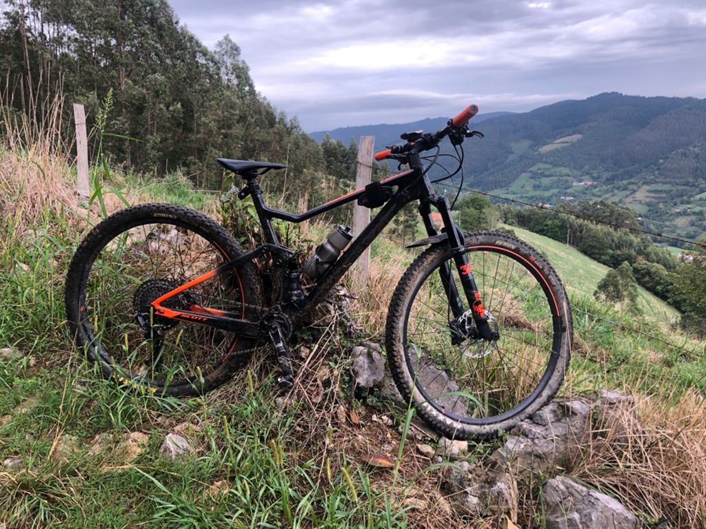
2 villas 2020

MTB
MTB
Ref..: 904809
Published: 20/09/2020
Performed: 19/09/2020
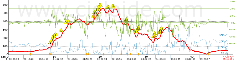
Distance in Km: 47.83
Climb in m: 1230
IBP: 111 BYC

Near ...
Aroles, Bandin, Baones, Baragaña (Carreño), Barquera, La (Carreño), Barreres (Albandi_Carreño)
Daniel Sanchez 2
563 published routes

Add to my Group or Club

 Height in m      Climb in %      Speed in Km/h      Speed < 2 Km/h

Climbs > 5%

Climbs >5% Climbs >10% Climbs >15% Climbs >20% Climbs >25%
 Steep slope of 108 m.   Average slope  Distances  Download as waypoint
1
 Km 8.694  6%  108 m
 Steep slope of 741 m.  Average slope  Distances  Download as waypoint
2
 Km 9.185  11%  143 m
3
 Km 9.328  8%  197 m
4
 Km 9.525  12%  34 m
5
 Km 9.559  18%  162 m
6
 Km 9.721  11%  70 m
7
 Km 9.791  7%  135 m
 Steep slope of 136 m.  Average slope  Distances  Download as waypoint
8
 Km 10.283  14%  104 m
9
 Km 10.387  9%  32 m
 Steep slope of 687 m.  Average slope  Distances  Download as waypoint
10
 Km 11.365  7%  74 m
11
 Km 11.439  12%  400 m
12
 Km 11.839  9%  213 m
 Steep slope of 128 m.  Average slope  Distances  Download as waypoint
13
 Km 12.161  8%  128 m
 Steep slope of 314 m.  Average slope  Distances  Download as waypoint
14
 Km 12.397  9%  212 m
15
 Km 12.609  11%  102 m
 Steep slope of 371 m.  Average slope  Distances  Download as waypoint
16
 Km 12.81  8%  34 m
17
 Km 12.844  12%  304 m
18
 Km 13.147  7%  33 m
 Steep slope of 362 m.  Average slope  Distances  Download as waypoint
19
 Km 13.795  7%  362 m
 Steep slope of 207 m.  Average slope  Distances  Download as waypoint
20
 Km 14.424  9%  207 m
 Steep slope of 369 m.  Average slope  Distances  Download as waypoint
21
 Km 17.334  9%  369 m
 Steep slope of 302 m.  Average slope  Distances  Download as waypoint
22
 Km 18.485  18%  268 m
23
 Km 18.752  11%  34 m
 Steep slope of 349 m.  Average slope  Distances  Download as waypoint
24
 Km 18.899  8%  349 m
 Steep slope of 431 m.  Average slope  Distances  Download as waypoint
25
 Km 19.357  12%  102 m
26
 Km 19.46  7%  161 m
27
 Km 19.621  12%  168 m
 Steep slope of 203 m.  Average slope  Distances  Download as waypoint
28
 Km 19.934  12%  133 m
29
 Km 20.067  11%  70 m
 Steep slope of 344 m.  Average slope  Distances  Download as waypoint
30
 Km 21.64  6%  35 m
31
 Km 21.674  12%  241 m
32
 Km 21.915  11%  68 m
 Steep slope of 368 m.  Average slope  Distances  Download as waypoint
33
 Km 22.677  9%  136 m
34
 Km 22.813  15%  164 m
35
 Km 22.977  7%  68 m
 Steep slope of 105 m.  Average slope  Distances  Download as waypoint
36
 Km 25.141  16%  105 m
 Steep slope of 271 m.  Average slope  Distances  Download as waypoint
37
 Km 25.671  16%  135 m
38
 Km 25.805  11%  136 m
 Steep slope of 434 m.  Average slope  Distances  Download as waypoint
39
 Km 27.915  13%  271 m
40
 Km 28.187  17%  61 m
41
 Km 28.247  20%  61 m
42
 Km 28.309  6%  41 m
 Steep slope of 147 m.  Average slope  Distances  Download as waypoint
43
 Km 29.986  5%  147 m
 Steep slope of 365 m.  Average slope  Distances  Download as waypoint
44
 Km 31.616  10%  34 m
45
 Km 31.65  13%  130 m
46
 Km 31.78  18%  100 m
47
 Km 31.879  13%  35 m
48
 Km 31.914  6%  66 m
 Steep slope of 456 m.  Average slope  Distances  Download as waypoint
49
 Km 32.962  13%  35 m
50
 Km 32.997  19%  104 m
51
 Km 33.101  14%  131 m
52
 Km 33.232  5%  119 m
53
 Km 33.35  12%  67 m
 Steep slope of 240 m.  Average slope  Distances  Download as waypoint
54
 Km 33.553  11%  240 m
 Steep slope of 334 m.  Average slope  Distances  Download as waypoint
55
 Km 33.931  7%  334 m
 Steep slope of 146 m.  Average slope  Distances  Download as waypoint
56
 Km 37.242  9%  146 m
 Steep slope of 111 m.  Average slope  Distances  Download as waypoint
57
 Km 37.674  9%  111 m


Description of the route


Presence of ramps


 Climbs  Distance  % of the total  Speed  Your speed would be  Time  Your time would be
   15 - 30%  1.382  2.89  3.86  ?  0:21:28  ?
   10 - 15%  3.332  6.97  5.66  ?  0:35:19  ?
   5 - 10%  4.651  9.73  7.64  ?  0:36:31  ?
   1 - 5%  9.313  19.47  11.04  ?  0:50:36  ?
   Total*  18.678 Km  39.05 %  7.79 Km/h  ? Km/h    2:23:54 h  ? h  
 Flat
   1 - -1%  12.623 Km  26.39 %  15.11 Km/h  ? Km/h    0:50:07 h  ? h  
 Descents
   -1 - -5%  7.615  15.92  15.93  ?  0:28:41  ?
   -5 - -10%  4.261  8.91  18.71  ?  0:13:40  ?
   -10 - -15%  2.623  5.48  14.62  ?  0:10:46  ?
   -15 - -30%  2.027  4.24  9.68  ?  0:12:34  ?
   Total*  16.526 Km  34.55 %  15.1 Km/h  ? Km/h    1:05:41 h  ? h  
* The total has not necessarily coincide with the sum of the partials after correction of errors

How long would it take you?

How long would it take you to cover this route?
There are routes without a valid time information, but with your average stats you can assess the possible duration

Daniel Sanchez 2 to cover this route you've need a time of:   4:19:42 h 
If you sign in and have a minimum of two tracks of this same modality, you can know your time for this route, calculated from your stats..


¿Cuanto consumirá tu E-BIKE?

Entra tu E-IBP (formato n,nn)

E-IBP :   X 111 = 


 Detected activity type =  ()
 Penalization due to track conditions: 75 %   ( > 50 % = MTB, < 50 % = RDB)
 Reliability of the track: B   (1230/59/0/-/-/59)
 Correction level applied to the track: 0
DIFFICULTY OF THE ROUTE
IBP = 111 BYC
According to your statistics
 Your time in motion would be: ? h
Your average speed would be: ? Km/h
 

 Total Distance: 47.83 Km
 Analysed distance: 47.83 Km
 Linear distance: 0.02 Km

 Cumulated positive ramps: 1229.6 m  list of points info
 Cumulated negative ramps: 1221.8 m
 Maximum height: 556.8 m
 Minimum height: 6.4 m
 Climbing Ratio: 6.58 %
 Descent ratio: 7.39 %
 Cumulated postive ramps per Km: 25.71 m
 Cumulated negative ramps per Km: 25.54 m

 Total time: 5:48:52 h
 Time in movement: 4:19:42 h
 According to your statistics
 Your time in motion would be: ? h  
 Stopped time: 1:29:10 h
 Maximum slope filter: ~30 %
 Minimum separation analysed: ~30 m
 Number of points: 3722   (cad. 12.85 m)
 Significant waypoints: 1348   (cad. 35.48 m / 36.22 %)

 Changes in direction per Km: 11.19
 Changes in direction > 5º por Km: 7.46
 Cumulated straight stretches: 10.304 Km
 Straight stretches per Km: 215.43 m
 Penalized slope changes: 13
 Penalized slope changes per Km: 0.272

 Average speed in total: 8.23 Km/h
 Average speed while moving: 11.05 Km/h
 According to your statistics
 Your average speed would be: ? Km/h  
 Maximum sustained speed: 49.09 Km/h


Comments

You can be the first one in commenting this route

 
My comments
:
Add comment  (Registered users)
 
Notify me answers to my comment  Do not notify answers to my comment


Share this route with a friend

Your friend will receive a message with a link to this page:
will see your email and your user name if you do it as registered user.


Write here your name (optional)

E-mail address of your friend(s). You can include various addresses separated by commas

Text or comment (optional) maximum 255 characters long, 255 Available characters

As a non registered users you need to fill-in the captcha text.
  Change image
Type the image characters.
 
 Share with a friend


Visited history

Delete history

Marked routes for review later or compare

My favorites


  Notify anomaly in this route Share in Facebook