La lengua fuera con el niñito!!!!

MTB
MTB
Ref..: 901750
Published: 08/09/2020
Performed: 07/09/2020
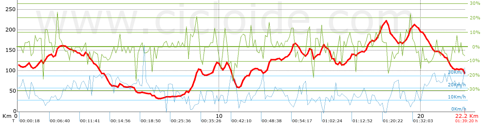
Distance in Km: 22.15
Climb in m: 616
IBP: 66 BYC

torpedillo
Author: torpedillo
153 published routes

Add to my Group or Club

 Height in m      Climb in %      Speed in Km/h      Speed < 2 Km/h

Climbs > 5%

Climbs >5% Climbs >10% Climbs >15% Climbs >20% Climbs >25%
 Steep slope of 101 m.   Average slope  Distances  Download as waypoint
1
 Km 0.833  7%  101 m
 Steep slope of 114 m.  Average slope  Distances  Download as waypoint
2
 Km 1.391  9%  114 m
 Steep slope of 197 m.  Average slope  Distances  Download as waypoint
3
 Km 1.876  11%  197 m
 Steep slope of 445 m.  Average slope  Distances  Download as waypoint
4
 Km 8.503  9%  64 m
5
 Km 8.567  11%  279 m
6
 Km 8.847  15%  102 m
 Steep slope of 166 m.  Average slope  Distances  Download as waypoint
7
 Km 9.668  6%  42 m
8
 Km 9.71  16%  124 m
 Steep slope of 140 m.  Average slope  Distances  Download as waypoint
9
 Km 10.202  13%  140 m
 Steep slope of 274 m.  Average slope  Distances  Download as waypoint
10
 Km 11.038  10%  274 m
 Steep slope of 116 m.  Average slope  Distances  Download as waypoint
11
 Km 11.486  12%  116 m
 Steep slope of 289 m.  Average slope  Distances  Download as waypoint
12
 Km 12.199  10%  289 m
 Steep slope of 293 m.  Average slope  Distances  Download as waypoint
13
 Km 13.445  7%  38 m
14
 Km 13.483  13%  217 m
15
 Km 13.7  6%  38 m
 Steep slope of 104 m.  Average slope  Distances  Download as waypoint
16
 Km 14.338  10%  104 m
 Steep slope of 107 m.  Average slope  Distances  Download as waypoint
17
 Km 14.701  5%  107 m
 Steep slope of 152 m.  Average slope  Distances  Download as waypoint
18
 Km 14.992  13%  113 m
19
 Km 15.105  21%  39 m
 Steep slope of 128 m.  Average slope  Distances  Download as waypoint
20
 Km 16.18  5%  128 m
 Steep slope of 119 m.  Average slope  Distances  Download as waypoint
21
 Km 16.429  10%  119 m
 Steep slope of 259 m.  Average slope  Distances  Download as waypoint
22
 Km 17.161  8%  259 m
 Steep slope of 335 m.  Average slope  Distances  Download as waypoint
23
 Km 17.739  10%  40 m
24
 Km 17.779  10%  193 m
25
 Km 17.972  13%  102 m
 Steep slope of 338 m.  Average slope  Distances  Download as waypoint
26
 Km 19.222  11%  338 m


Description of the route


Presence of ramps


 Climbs  Distance  % of the total  Speed  Your speed would be  Time  Your time would be
   15 - 30%  0.646  2.92  8.27  ?  0:04:41  ?
   10 - 15%  1.474  6.65  8.17  ?  0:10:49  ?
   5 - 10%  2.717  12.27  10.55  ?  0:15:27  ?
   1 - 5%  3.196  14.43  14.24  ?  0:13:28  ?
   Total*  8.033 Km  36.26 %  10.85 Km/h  ? Km/h    0:44:25 h  ? h  
 Flat
   1 - -1%  5.858 Km  26.44 %  17.6 Km/h  ? Km/h    0:19:58 h  ? h  
 Descents
   -1 - -5%  3.068  13.85  20.49  ?  0:08:59  ?
   -5 - -10%  3.244  14.64  20.59  ?  0:09:27  ?
   -10 - -15%  1.427  6.44  19.03  ?  0:04:30  ?
   -15 - -30%  0.524  2.36  14.73  ?  0:02:08  ?
   Total*  8.263 Km  37.3 %  19.78 Km/h  ? Km/h    0:25:04 h  ? h  
* The total has not necessarily coincide with the sum of the partials after correction of errors

How long would it take you?

How long would it take you to cover this route?
There are routes without a valid time information, but with your average stats you can assess the possible duration

torpedillo to cover this route you've need a time of:   1:29:27 h 
If you sign in and have a minimum of two tracks of this same modality, you can know your time for this route, calculated from your stats..


¿Cuanto consumirá tu E-BIKE?

Entra tu E-IBP (formato n,nn)

E-IBP :   X 66 = 


 Detected activity type =  ()
 Penalization due to track conditions: 81 %   ( > 50 % = MTB, < 50 % = RDB)
 Reliability of the track: B   (619/59/0/-/-/59)
 Correction level applied to the track: 0
DIFFICULTY OF THE ROUTE
IBP = 66 BYC
According to your statistics
 Your time in motion would be: ? h
Your average speed would be: ? Km/h
 

 Total Distance: 22.15 Km
 Analysed distance: 22.15 Km
 Linear distance: 2.19 Km

 Cumulated positive ramps: 615.6 m  list of points info
 Cumulated negative ramps: 637.1 m
 Maximum height: 222.1 m
 Minimum height: 31.9 m
 Climbing Ratio: 7.66 %
 Descent ratio: 7.71 %
 Cumulated postive ramps per Km: 27.79 m
 Cumulated negative ramps per Km: 28.76 m

 Total time: 1:39:20 h
 Time in movement: 1:29:27 h
 According to your statistics
 Your time in motion would be: ? h  
 Stopped time: 0:09:53 h
 Maximum slope filter: ~30 %
 Minimum separation analysed: ~30 m
 Number of points: 1535   (cad. 14.43 m)
 Significant waypoints: 610   (cad. 36.32 m / 39.74 %)

 Changes in direction per Km: 9.3
 Changes in direction > 5º por Km: 7.4
 Cumulated straight stretches: 3.212 Km
 Straight stretches per Km: 145.01 m
 Penalized slope changes: 6
 Penalized slope changes per Km: 0.271

 Average speed in total: 13.38 Km/h
 Average speed while moving: 14.86 Km/h
 According to your statistics
 Your average speed would be: ? Km/h  
 Maximum sustained speed: 38.12 Km/h


Comments

You can be the first one in commenting this route

 
My comments
:
Add comment  (Registered users)
 
Notify me answers to my comment  Do not notify answers to my comment


Share this route with a friend

Your friend will receive a message with a link to this page:
will see your email and your user name if you do it as registered user.


Write here your name (optional)

E-mail address of your friend(s). You can include various addresses separated by commas

Text or comment (optional) maximum 255 characters long, 255 Available characters

As a non registered users you need to fill-in the captcha text.
  Change image
Type the image characters.
 
 Share with a friend


Visited history

Delete history

Marked routes for review later or compare

My favorites


  Notify anomaly in this route Share in Facebook