Metiendo km y metros

MTB
MTB
Ref..: 901319
Published: 06/09/2020
Performed: 06/09/2020
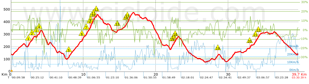
Distance in Km: 39.7
Climb in m: 1313
IBP: 93 BYC

prumover
Author: prumover
445 published routes

Add to my Group or Club

 Height in m      Climb in %      Speed in Km/h      Speed < 2 Km/h

Climbs > 5%

Climbs >5% Climbs >10% Climbs >15% Climbs >20% Climbs >25%
 Steep slope of 803 m.   Average slope  Distances  Download as waypoint
1
 Km 0.234  7%  803 m
 Steep slope of 298 m.  Average slope  Distances  Download as waypoint
2
 Km 1.3  6%  298 m
 Steep slope of 413 m.  Average slope  Distances  Download as waypoint
3
 Km 2.297  10%  33 m
4
 Km 2.33  12%  233 m
5
 Km 2.562  8%  147 m
 Steep slope of 341 m.  Average slope  Distances  Download as waypoint
6
 Km 2.815  6%  35 m
7
 Km 2.85  11%  134 m
8
 Km 2.984  12%  172 m
 Steep slope of 239 m.  Average slope  Distances  Download as waypoint
9
 Km 3.497  13%  137 m
10
 Km 3.634  5%  102 m
 Steep slope of 247 m.  Average slope  Distances  Download as waypoint
11
 Km 3.879  15%  143 m
12
 Km 4.022  9%  104 m
 Steep slope of 214 m.  Average slope  Distances  Download as waypoint
13
 Km 5.154  9%  214 m
 Steep slope of 216 m.  Average slope  Distances  Download as waypoint
14
 Km 6.422  9%  216 m
 Steep slope of 894 m.  Average slope  Distances  Download as waypoint
15
 Km 7.763  5%  182 m
16
 Km 7.945  11%  242 m
17
 Km 8.186  7%  470 m
 Steep slope of 256 m.  Average slope  Distances  Download as waypoint
18
 Km 8.756  7%  256 m
 Steep slope of 410 m.  Average slope  Distances  Download as waypoint
19
 Km 9.169  9%  410 m
 Steep slope of 952 m.  Average slope  Distances  Download as waypoint
20
 Km 9.765  9%  35 m
21
 Km 9.8  13%  174 m
22
 Km 9.973  7%  391 m
23
 Km 10.364  11%  110 m
24
 Km 10.474  10%  242 m
 Steep slope of 788 m.  Average slope  Distances  Download as waypoint
25
 Km 10.822  11%  101 m
26
 Km 10.923  15%  300 m
27
 Km 11.223  12%  105 m
28
 Km 11.329  13%  103 m
29
 Km 11.432  9%  179 m
 Steep slope of 206 m.  Average slope  Distances  Download as waypoint
30
 Km 11.724  6%  31 m
31
 Km 11.755  12%  108 m
32
 Km 11.864  7%  67 m
 Steep slope of 201 m.  Average slope  Distances  Download as waypoint
33
 Km 14.567  9%  68 m
34
 Km 14.635  10%  102 m
35
 Km 14.737  7%  31 m
 Steep slope of 136 m.  Average slope  Distances  Download as waypoint
36
 Km 15.446  6%  136 m
 Steep slope of 1057 m.  Average slope  Distances  Download as waypoint
37
 Km 15.695  8%  212 m
38
 Km 15.907  11%  97 m
39
 Km 16.004  5%  105 m
40
 Km 16.109  13%  438 m
41
 Km 16.547  9%  205 m
 Steep slope of 1016 m.  Average slope  Distances  Download as waypoint
42
 Km 22.02  9%  209 m
43
 Km 22.229  14%  102 m
44
 Km 22.331  8%  129 m
45
 Km 22.46  14%  97 m
46
 Km 22.556  6%  109 m
47
 Km 22.665  13%  100 m
48
 Km 22.765  8%  270 m
 Steep slope of 209 m.  Average slope  Distances  Download as waypoint
49
 Km 27.407  7%  209 m
 Steep slope of 495 m.  Average slope  Distances  Download as waypoint
50
 Km 28.163  8%  354 m
51
 Km 28.517  11%  103 m
52
 Km 28.62  6%  38 m
 Steep slope of 252 m.  Average slope  Distances  Download as waypoint
53
 Km 29.872  6%  252 m
 Steep slope of 584 m.  Average slope  Distances  Download as waypoint
54
 Km 30.408  8%  376 m
55
 Km 30.783  9%  106 m
56
 Km 30.89  10%  102 m
 Steep slope of 248 m.  Average slope  Distances  Download as waypoint
57
 Km 32.451  8%  248 m
 Steep slope of 215 m.  Average slope  Distances  Download as waypoint
58
 Km 32.996  13%  144 m
59
 Km 33.14  8%  71 m
 Steep slope of 985 m.  Average slope  Distances  Download as waypoint
60
 Km 33.562  10%  201 m
61
 Km 33.763  10%  138 m
62
 Km 33.901  9%  313 m
63
 Km 34.214  10%  97 m
64
 Km 34.311  8%  236 m
 Steep slope of 144 m.  Average slope  Distances  Download as waypoint
65
 Km 36.202  7%  144 m


Description of the route


Presence of ramps


 Climbs  Distance  % of the total  Speed  Your speed would be  Time  Your time would be
   15 - 30%  0.515  1.3  6.14  ?  0:05:02  ?
   10 - 15%  3.557  8.96  6.31  ?  0:33:48  ?
   5 - 10%  8.248  20.78  8.12  ?  1:00:58  ?
   1 - 5%  6.145  15.48  11.77  ?  0:31:20  ?
   Total*  18.465 Km  46.52 %  8.45 Km/h  ? Km/h    2:11:08 h  ? h  
 Flat
   1 - -1%  2.58 Km  6.5 %  15.03 Km/h  ? Km/h    0:10:18 h  ? h  
 Descents
   -1 - -5%  7.232  18.22  21.9  ?  0:19:49  ?
   -5 - -10%  6.704  16.89  29.33  ?  0:13:43  ?
   -10 - -15%  3.929  9.9  20.71  ?  0:11:23  ?
   -15 - -30%  0.786  1.98  14.02  ?  0:03:22  ?
   Total*  18.652 Km  46.99 %  23.18 Km/h  ? Km/h    0:48:17 h  ? h  
* The total has not necessarily coincide with the sum of the partials after correction of errors

How long would it take you?

How long would it take you to cover this route?
There are routes without a valid time information, but with your average stats you can assess the possible duration

prumover to cover this route you've need a time of:   3:09:43 h 
If you sign in and have a minimum of two tracks of this same modality, you can know your time for this route, calculated from your stats..


¿Cuanto consumirá tu E-BIKE?

Entra tu E-IBP (formato n,nn)

E-IBP :   X 93 = 


 Detected activity type =  ()
 Penalization due to track conditions: 59 %   ( > 50 % = MTB, < 50 % = RDB)
 Reliability of the track: A   (1314/76/0/-/-/76)
 Correction level applied to the track: 0
DIFFICULTY OF THE ROUTE
IBP = 93 BYC
According to your statistics
 Your time in motion would be: ? h
Your average speed would be: ? Km/h
 

 Total Distance: 39.7 Km
 Analysed distance: 39.7 Km
 Linear distance: 0 Km

 Cumulated positive ramps: 1312.6 m  list of points info
 Cumulated negative ramps: 1306.7 m
 Maximum height: 475.6 m
 Minimum height: 75.7 m
 Climbing Ratio: 7.11 %
 Descent ratio: 7.01 %
 Cumulated postive ramps per Km: 33.06 m
 Cumulated negative ramps per Km: 32.91 m

 Total time: 3:30:39 h
 Time in movement: 3:09:43 h
 According to your statistics
 Your time in motion would be: ? h  
 Stopped time: 0:20:56 h
 Maximum slope filter: ~30 %
 Minimum separation analysed: ~30 m
 Number of points: 2877   (cad. 13.8 m)
 Significant waypoints: 1073   (cad. 37 m / 37.3 %)

 Changes in direction per Km: 11.34
 Changes in direction > 5º por Km: 9.17
 Cumulated straight stretches: 4.881 Km
 Straight stretches per Km: 122.95 m
 Penalized slope changes: 13
 Penalized slope changes per Km: 0.327

 Average speed in total: 11.31 Km/h
 Average speed while moving: 12.56 Km/h
 According to your statistics
 Your average speed would be: ? Km/h  
 Maximum sustained speed: 62.72 Km/h


Comments

You can be the first one in commenting this route

 
My comments
:
Add comment  (Registered users)
 
Notify me answers to my comment  Do not notify answers to my comment


Share this route with a friend

Your friend will receive a message with a link to this page:
will see your email and your user name if you do it as registered user.


Write here your name (optional)

E-mail address of your friend(s). You can include various addresses separated by commas

Text or comment (optional) maximum 255 characters long, 255 Available characters

As a non registered users you need to fill-in the captcha text.
  Change image
Type the image characters.
 
 Share with a friend


Visited history

Delete history

Marked routes for review later or compare

My favorites


  Notify anomaly in this route Share in Facebook