Ametlla De Casserres, L' (Barcelona)

MTB
MTB
Ref..: 894717
Published: 14/08/2020
Performed: 14/08/2020
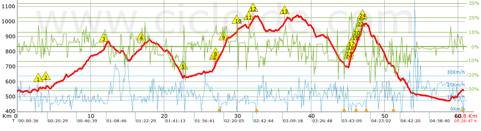
Distance in Km: 60.83
Climb in m: 1724
IBP: 127 BYC

Near ...
Ametlla De Casserres, L', Cal Rosal (Olvan), Colonia Rosal, La (Berga), Gironella, Guixaro, El, Olvan

 Height in m      Climb in %      Speed in Km/h      Speed < 2 Km/h

Climbs > 5%

Climbs >5% Climbs >10% Climbs >15% Climbs >20% Climbs >25%
 Steep slope of 179 m.   Average slope  Distances  Download as waypoint
1
 Km 1.887  7%  179 m
 Steep slope of 268 m.  Average slope  Distances  Download as waypoint
2
 Km 2.79  9%  35 m
3
 Km 2.825  12%  132 m
4
 Km 2.957  5%  101 m
 Steep slope of 103 m.  Average slope  Distances  Download as waypoint
5
 Km 3.339  7%  103 m
 Steep slope of 142 m.  Average slope  Distances  Download as waypoint
6
 Km 3.875  12%  142 m
 Steep slope of 166 m.  Average slope  Distances  Download as waypoint
7
 Km 4.586  8%  166 m
 Steep slope of 139 m.  Average slope  Distances  Download as waypoint
8
 Km 4.884  7%  139 m
 Steep slope of 417 m.  Average slope  Distances  Download as waypoint
9
 Km 6.25  9%  417 m
 Steep slope of 139 m.  Average slope  Distances  Download as waypoint
10
 Km 7.594  6%  139 m
 Steep slope of 163 m.  Average slope  Distances  Download as waypoint
11
 Km 8.162  7%  163 m
 Steep slope of 321 m.  Average slope  Distances  Download as waypoint
12
 Km 8.791  8%  321 m
 Steep slope of 202 m.  Average slope  Distances  Download as waypoint
13
 Km 9.224  10%  202 m
 Steep slope of 344 m.  Average slope  Distances  Download as waypoint
14
 Km 9.669  7%  344 m
 Steep slope of 484 m.  Average slope  Distances  Download as waypoint
15
 Km 11.809  13%  170 m
16
 Km 11.98  10%  314 m
 Steep slope of 141 m.  Average slope  Distances  Download as waypoint
17
 Km 13.959  7%  141 m
 Steep slope of 475 m.  Average slope  Distances  Download as waypoint
18
 Km 15.31  8%  475 m
 Steep slope of 265 m.  Average slope  Distances  Download as waypoint
19
 Km 15.965  6%  265 m
 Steep slope of 241 m.  Average slope  Distances  Download as waypoint
20
 Km 16.833  7%  34 m
21
 Km 16.867  15%  103 m
22
 Km 16.97  6%  104 m
 Steep slope of 139 m.  Average slope  Distances  Download as waypoint
23
 Km 17.284  12%  139 m
 Steep slope of 207 m.  Average slope  Distances  Download as waypoint
24
 Km 17.738  8%  207 m
 Steep slope of 105 m.  Average slope  Distances  Download as waypoint
25
 Km 20.176  6%  105 m
 Steep slope of 101 m.  Average slope  Distances  Download as waypoint
26
 Km 22.593  15%  101 m
 Steep slope of 170 m.  Average slope  Distances  Download as waypoint
27
 Km 25.128  6%  170 m
 Steep slope of 2173 m.  Average slope  Distances  Download as waypoint
28
 Km 26.476  8%  323 m
29
 Km 26.799  11%  102 m
30
 Km 26.902  14%  98 m
31
 Km 27  14%  68 m
32
 Km 27.068  9%  1024 m
33
 Km 28.092  14%  350 m
34
 Km 28.442  9%  208 m
 Steep slope of 207 m.  Average slope  Distances  Download as waypoint
35
 Km 29.819  14%  207 m
 Steep slope of 811 m.  Average slope  Distances  Download as waypoint
36
 Km 31.479  14%  139 m
37
 Km 31.618  8%  472 m
38
 Km 32.09  11%  135 m
39
 Km 32.225  10%  65 m
 Steep slope of 110 m.  Average slope  Distances  Download as waypoint
40
 Km 34.171  6%  110 m
 Steep slope of 139 m.  Average slope  Distances  Download as waypoint
41
 Km 35.601  7%  139 m
 Steep slope of 107 m.  Average slope  Distances  Download as waypoint
42
 Km 35.844  5%  107 m
 Steep slope of 550 m.  Average slope  Distances  Download as waypoint
43
 Km 36.166  8%  217 m
44
 Km 36.382  12%  104 m
45
 Km 36.487  8%  229 m
 Steep slope of 204 m.  Average slope  Distances  Download as waypoint
46
 Km 37.323  8%  204 m
 Steep slope of 111 m.  Average slope  Distances  Download as waypoint
47
 Km 37.867  5%  111 m
 Steep slope of 105 m.  Average slope  Distances  Download as waypoint
48
 Km 42.064  11%  105 m
 Steep slope of 1955 m.  Average slope  Distances  Download as waypoint
49
 Km 45.061  18%  69 m
50
 Km 45.13  20%  272 m
51
 Km 45.403  23%  74 m
52
 Km 45.476  11%  30 m
53
 Km 45.507  8%  468 m
54
 Km 45.975  12%  35 m
55
 Km 46.01  17%  135 m
56
 Km 46.146  14%  372 m
57
 Km 46.518  8%  132 m
58
 Km 46.65  20%  37 m
59
 Km 46.687  23%  138 m
60
 Km 46.825  12%  97 m
61
 Km 46.922  16%  63 m
62
 Km 46.986  13%  33 m
 Steep slope of 140 m.  Average slope  Distances  Download as waypoint
63
 Km 47.117  9%  140 m
 Steep slope of 243 m.  Average slope  Distances  Download as waypoint
64
 Km 52.155  7%  243 m
 Steep slope of 251 m.  Average slope  Distances  Download as waypoint
65
 Km 58.827  9%  251 m
 Steep slope of 355 m.  Average slope  Distances  Download as waypoint
66
 Km 59.801  7%  355 m
 Steep slope of 169 m.  Average slope  Distances  Download as waypoint
67
 Km 60.287  6%  169 m


Description of the route


Presence of ramps


 Climbs  Distance  % of the total  Speed  Your speed would be  Time  Your time would be
   15 - 30%  1.494  2.46  8.06  ?  0:11:07  ?
   10 - 15%  2.749  4.52  8.34  ?  0:19:47  ?
   5 - 10%  8.988  14.78  10.29  ?  0:52:23  ?
   1 - 5%  14.459  23.77  11.68  ?  1:14:17  ?
   Total*  27.69 Km  45.52 %  10.54 Km/h  ? Km/h    2:37:34 h  ? h  
 Flat
   1 - -1%  7.511 Km  12.35 %  15.95 Km/h  ? Km/h    0:28:15 h  ? h  
 Descents
   -1 - -5%  11.063  18.19  16.8  ?  0:39:31  ?
   -5 - -10%  8.695  14.29  17.74  ?  0:29:24  ?
   -10 - -15%  4.451  7.32  16.59  ?  0:16:06  ?
   -15 - -30%  1.415  2.33  16.86  ?  0:05:02  ?
   Total*  25.624 Km  42.13 %  17.07 Km/h  ? Km/h    1:30:03 h  ? h  
* The total has not necessarily coincide with the sum of the partials after correction of errors

How long would it take you?

How long would it take you to cover this route?
There are routes without a valid time information, but with your average stats you can assess the possible duration

Juan Carlos Gutiérrez to cover this route you've need a time of:   4:35:52 h 
If you sign in and have a minimum of two tracks of this same modality, you can know your time for this route, calculated from your stats..


¿Cuanto consumirá tu E-BIKE?

Entra tu E-IBP (formato n,nn)

E-IBP :   X 127 = 


 Detected activity type =  ()
 Penalization due to track conditions: 69 %   ( > 50 % = MTB, < 50 % = RDB)
 Reliability of the track: B   (1726/66/0/-/-/66)
 Correction level applied to the track: 0
DIFFICULTY OF THE ROUTE
IBP = 127 BYC
According to your statistics
 Your time in motion would be: ? h
Your average speed would be: ? Km/h
 

 Total Distance: 60.83 Km
 Analysed distance: 60.83 Km
 Linear distance: 0.14 Km

 Cumulated positive ramps: 1724.1 m  list of points info
 Cumulated negative ramps: 1713.3 m
 Maximum height: 1042.4 m
 Minimum height: 471.8 m
 Climbing Ratio: 6.23 %
 Descent ratio: 6.69 %
 Cumulated postive ramps per Km: 28.34 m
 Cumulated negative ramps per Km: 28.17 m

 Total time: 5:26:47 h
 Time in movement: 4:35:52 h
 According to your statistics
 Your time in motion would be: ? h  
 Stopped time: 0:50:55 h
 Maximum slope filter: ~30 %
 Minimum separation analysed: ~30 m
 Number of points: 5018   (cad. 12.12 m)
 Significant waypoints: 1698   (cad. 35.82 m / 33.84 %)

 Changes in direction per Km: 12.26
 Changes in direction > 5º por Km: 9.63
 Cumulated straight stretches: 8.986 Km
 Straight stretches per Km: 147.72 m
 Penalized slope changes: 16
 Penalized slope changes per Km: 0.263

 Average speed in total: 11.17 Km/h
 Average speed while moving: 13.23 Km/h
 According to your statistics
 Your average speed would be: ? Km/h  
 Maximum sustained speed: 48.7 Km/h


Comments

You can be the first one in commenting this route

 
My comments
:
Add comment  (Registered users)
 
Notify me answers to my comment  Do not notify answers to my comment


Share this route with a friend

Your friend will receive a message with a link to this page:
will see your email and your user name if you do it as registered user.


Write here your name (optional)

E-mail address of your friend(s). You can include various addresses separated by commas

Text or comment (optional) maximum 255 characters long, 255 Available characters

As a non registered users you need to fill-in the captcha text.
  Change image
Type the image characters.
 
 Share with a friend


Visited history

Delete history

Marked routes for review later or compare

My favorites


  Notify anomaly in this route Share in Facebook