Sta. Eulàlia de Riuprimer #84

Road
Road
Ref..: 887363
Published: 19/07/2020
Performed: 18/07/2020
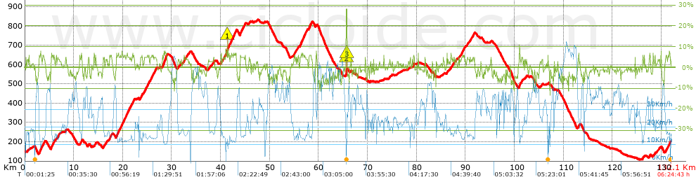
Distance in Km: 132.1
Climb in m: 2063
IBP: 137 BYC

Santi Dongil Diaz
924 published routes

Add to my Group or Club

 Height in m      Climb in %      Speed in Km/h      Speed < 2 Km/h

Climbs > 5%

Climbs >5% Climbs >10% Climbs >15% Climbs >20% Climbs >25%
 Steep slope of 497 m.   Average slope  Distances  Download as waypoint
1
 Km 2.94  6%  497 m
 Steep slope of 260 m.  Average slope  Distances  Download as waypoint
2
 Km 3.615  5%  260 m
 Steep slope of 411 m.  Average slope  Distances  Download as waypoint
3
 Km 5.356  6%  411 m
 Steep slope of 240 m.  Average slope  Distances  Download as waypoint
4
 Km 5.905  6%  240 m
 Steep slope of 225 m.  Average slope  Distances  Download as waypoint
5
 Km 11.47  6%  225 m
 Steep slope of 97 m.  Average slope  Distances  Download as waypoint
6
 Km 14.13  6%  97 m
 Steep slope of 304 m.  Average slope  Distances  Download as waypoint
7
 Km 17.334  6%  304 m
 Steep slope of 462 m.  Average slope  Distances  Download as waypoint
8
 Km 18.709  6%  462 m
 Steep slope of 114 m.  Average slope  Distances  Download as waypoint
9
 Km 19.27  5%  114 m
 Steep slope of 172 m.  Average slope  Distances  Download as waypoint
10
 Km 19.522  5%  172 m
 Steep slope of 357 m.  Average slope  Distances  Download as waypoint
11
 Km 19.84  6%  357 m
 Steep slope of 167 m.  Average slope  Distances  Download as waypoint
12
 Km 20.298  6%  167 m
 Steep slope of 673 m.  Average slope  Distances  Download as waypoint
13
 Km 20.669  6%  673 m
 Steep slope of 143 m.  Average slope  Distances  Download as waypoint
14
 Km 21.556  5%  143 m
 Steep slope of 137 m.  Average slope  Distances  Download as waypoint
15
 Km 21.93  6%  137 m
 Steep slope of 207 m.  Average slope  Distances  Download as waypoint
16
 Km 22.175  5%  207 m
 Steep slope of 246 m.  Average slope  Distances  Download as waypoint
17
 Km 23.765  6%  246 m
 Steep slope of 221 m.  Average slope  Distances  Download as waypoint
18
 Km 24.271  5%  221 m
 Steep slope of 115 m.  Average slope  Distances  Download as waypoint
19
 Km 24.651  6%  115 m
 Steep slope of 335 m.  Average slope  Distances  Download as waypoint
20
 Km 24.955  6%  335 m
 Steep slope of 375 m.  Average slope  Distances  Download as waypoint
21
 Km 25.648  5%  375 m
 Steep slope of 111 m.  Average slope  Distances  Download as waypoint
22
 Km 26.174  5%  111 m
 Steep slope of 186 m.  Average slope  Distances  Download as waypoint
23
 Km 26.511  5%  186 m
 Steep slope of 840 m.  Average slope  Distances  Download as waypoint
24
 Km 28.112  7%  840 m
 Steep slope of 189 m.  Average slope  Distances  Download as waypoint
25
 Km 40.036  6%  189 m
 Steep slope of 539 m.  Average slope  Distances  Download as waypoint
26
 Km 41.228  6%  178 m
27
 Km 41.406  12%  102 m
28
 Km 41.508  6%  259 m
 Steep slope of 503 m.  Average slope  Distances  Download as waypoint
29
 Km 41.956  6%  503 m
 Steep slope of 543 m.  Average slope  Distances  Download as waypoint
30
 Km 42.558  6%  543 m
 Steep slope of 421 m.  Average slope  Distances  Download as waypoint
31
 Km 43.959  6%  421 m
 Steep slope of 117 m.  Average slope  Distances  Download as waypoint
32
 Km 44.503  5%  117 m
 Steep slope of 118 m.  Average slope  Distances  Download as waypoint
33
 Km 44.785  5%  118 m
 Steep slope of 328 m.  Average slope  Distances  Download as waypoint
34
 Km 54.967  5%  328 m
 Steep slope of 115 m.  Average slope  Distances  Download as waypoint
35
 Km 55.806  5%  115 m
 Steep slope of 603 m.  Average slope  Distances  Download as waypoint
36
 Km 56.205  6%  603 m
 Steep slope of 444 m.  Average slope  Distances  Download as waypoint
37
 Km 56.92  6%  444 m
 Steep slope of 341 m.  Average slope  Distances  Download as waypoint
38
 Km 58.046  6%  341 m
 Steep slope of 158 m.  Average slope  Distances  Download as waypoint
39
 Km 65.641  28%  115 m
40
 Km 65.756  17%  43 m
 Steep slope of 223 m.  Average slope  Distances  Download as waypoint
41
 Km 79.312  6%  223 m
 Steep slope of 132 m.  Average slope  Distances  Download as waypoint
42
 Km 86.156  6%  132 m
 Steep slope of 150 m.  Average slope  Distances  Download as waypoint
43
 Km 89.182  6%  150 m
 Steep slope of 323 m.  Average slope  Distances  Download as waypoint
44
 Km 89.441  6%  323 m
 Steep slope of 113 m.  Average slope  Distances  Download as waypoint
45
 Km 91.672  5%  113 m
 Steep slope of 244 m.  Average slope  Distances  Download as waypoint
46
 Km 100.957  7%  244 m
 Steep slope of 124 m.  Average slope  Distances  Download as waypoint
47
 Km 113.056  7%  124 m
 Steep slope of 146 m.  Average slope  Distances  Download as waypoint
48
 Km 126.194  6%  146 m
 Steep slope of 107 m.  Average slope  Distances  Download as waypoint
49
 Km 127.636  6%  107 m
 Steep slope of 169 m.  Average slope  Distances  Download as waypoint
50
 Km 128.647  6%  169 m
 Steep slope of 130 m.  Average slope  Distances  Download as waypoint
51
 Km 130.889  6%  130 m
 Steep slope of 220 m.  Average slope  Distances  Download as waypoint
52
 Km 131.361  5%  220 m
 Steep slope of 102 m.  Average slope  Distances  Download as waypoint
53
 Km 131.731  6%  102 m


Description of the route


Presence of ramps


 Climbs  Distance  % of the total  Speed  Your speed would be  Time  Your time would be
   15 - 30%  0.158  0.12  28.41  ?  0:00:20  ?
   10 - 15%  0.205  0.16  10.39  ?  0:01:11  ?
   5 - 10%  15.991  12.11  14.38  ?  1:06:43  ?
   1 - 5%  34.145  25.85  18.31  ?  1:51:55  ?
   Total*  50.499 Km  38.23 %  16.82 Km/h  ? Km/h    3:00:09 h  ? h  
 Flat
   1 - -1%  29.686 Km  22.47 %  27.35 Km/h  ? Km/h    1:05:07 h  ? h  
 Descents
   -1 - -5%  37.15  28.12  35.61  ?  1:02:36  ?
   -5 - -10%  14.3  10.83  36.59  ?  0:23:27  ?
   -10 - -15%  0.465  0.35  28.35  ?  0:00:59  ?
   -15 - -30%  0  0  0  ?  0:00:00  ?
   Total*  51.914 Km  39.3 %  35.79 Km/h  ? Km/h    1:27:02 h  ? h  
* The total has not necessarily coincide with the sum of the partials after correction of errors

How long would it take you?

How long would it take you to cover this route?
There are routes without a valid time information, but with your average stats you can assess the possible duration

Santi Dongil Diaz to cover this route you've need a time of:   5:32:18 h 
If you sign in and have a minimum of two tracks of this same modality, you can know your time for this route, calculated from your stats..


¿Cuanto consumirá tu E-BIKE?

Entra tu E-IBP (formato n,nn)

E-IBP :   X 137 = 


 Detected activity type =  ()
 Penalization due to track conditions: 38 %   ( > 50 % = MTB, < 50 % = RDB)
 Reliability of the track: A   (2063/81/0/-/-/81)
 Correction level applied to the track: 0
DIFFICULTY OF THE ROUTE
IBP = 137 BYC
According to your statistics
 Your time in motion would be: ? h
Your average speed would be: ? Km/h
 

 Total Distance: 132.1 Km
 Analysed distance: 132.1 Km
 Linear distance: 0.25 Km

 Cumulated positive ramps: 2062.6 m  list of points info
 Cumulated negative ramps: 2003 m
 Maximum height: 834.6 m
 Minimum height: 107.8 m
 Climbing Ratio: 4.08 %
 Descent ratio: 3.86 %
 Cumulated postive ramps per Km: 15.61 m
 Cumulated negative ramps per Km: 15.16 m

 Total time: 6:24:43 h
 Time in movement: 5:32:18 h
 According to your statistics
 Your time in motion would be: ? h  
 Stopped time: 0:52:25 h
 Maximum slope filter: ~30 %
 Minimum separation analysed: ~30 m
 Number of points: 10072   (cad. 13.12 m)
 Significant waypoints: 3734   (cad. 35.38 m / 37.07 %)

 Changes in direction per Km: 8.61
 Changes in direction > 5º por Km: 4.35
 Cumulated straight stretches: 52.802 Km
 Straight stretches per Km: 399.71 m
 Penalized slope changes: 21
 Penalized slope changes per Km: 0.159

 Average speed in total: 20.6 Km/h
 Average speed while moving: 23.85 Km/h
 According to your statistics
 Your average speed would be: ? Km/h  
 Maximum sustained speed: 70.4 Km/h


Comments

You can be the first one in commenting this route

 
My comments
:
Add comment  (Registered users)
 
Notify me answers to my comment  Do not notify answers to my comment


Share this route with a friend

Your friend will receive a message with a link to this page:
will see your email and your user name if you do it as registered user.


Write here your name (optional)

E-mail address of your friend(s). You can include various addresses separated by commas

Text or comment (optional) maximum 255 characters long, 255 Available characters

As a non registered users you need to fill-in the captcha text.
  Change image
Type the image characters.
 
 Share with a friend


Visited history

Delete history

Marked routes for review later or compare

My favorites


  Notify anomaly in this route Share in Facebook