Turistas y más

Road
Road
Ref..: 886133
Published: 14/07/2020
Performed: 13/07/2020
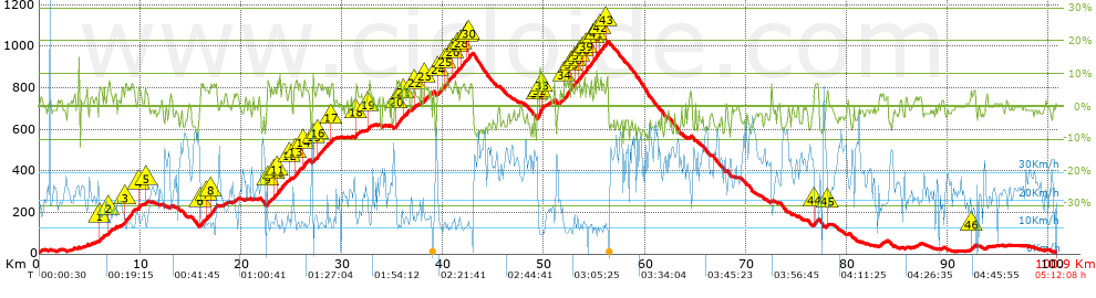
Distance in Km: 100.95
Climb in m: 1796
IBP: 111 BYC

Carlos_pesca
Author: Carlos_pesca
1446 published routes

Add to my Group or Club

 Height in m      Climb in %      Speed in Km/h      Speed < 2 Km/h

Climbs > 5%

Climbs >5% Climbs >10% Climbs >15% Climbs >20% Climbs >25%
 Steep slope of 151 m.   Average slope  Distances  Download as waypoint
1
 Km 5.983  5%  151 m
 Steep slope of 185 m.  Average slope  Distances  Download as waypoint
2
 Km 6.84  7%  185 m
 Steep slope of 964 m.  Average slope  Distances  Download as waypoint
3
 Km 8.508  6%  964 m
 Steep slope of 205 m.  Average slope  Distances  Download as waypoint
4
 Km 9.843  6%  205 m
 Steep slope of 99 m.  Average slope  Distances  Download as waypoint
5
 Km 10.542  5%  99 m
 Steep slope of 421 m.  Average slope  Distances  Download as waypoint
6
 Km 16  6%  421 m
 Steep slope of 195 m.  Average slope  Distances  Download as waypoint
7
 Km 16.553  5%  195 m
 Steep slope of 648 m.  Average slope  Distances  Download as waypoint
8
 Km 16.953  7%  648 m
 Steep slope of 386 m.  Average slope  Distances  Download as waypoint
9
 Km 22.629  6%  386 m
 Steep slope of 136 m.  Average slope  Distances  Download as waypoint
10
 Km 23.295  6%  136 m
 Steep slope of 698 m.  Average slope  Distances  Download as waypoint
11
 Km 23.59  7%  698 m
 Steep slope of 142 m.  Average slope  Distances  Download as waypoint
12
 Km 24.784  5%  142 m
 Steep slope of 586 m.  Average slope  Distances  Download as waypoint
13
 Km 25.346  6%  586 m
 Steep slope of 437 m.  Average slope  Distances  Download as waypoint
14
 Km 26.175  7%  437 m
 Steep slope of 136 m.  Average slope  Distances  Download as waypoint
15
 Km 27.12  7%  136 m
 Steep slope of 1047 m.  Average slope  Distances  Download as waypoint
16
 Km 27.563  6%  1047 m
 Steep slope of 314 m.  Average slope  Distances  Download as waypoint
17
 Km 28.842  6%  314 m
 Steep slope of 247 m.  Average slope  Distances  Download as waypoint
18
 Km 31.351  6%  247 m
 Steep slope of 213 m.  Average slope  Distances  Download as waypoint
19
 Km 32.581  6%  213 m
 Steep slope of 587 m.  Average slope  Distances  Download as waypoint
20
 Km 35.353  7%  587 m
 Steep slope of 601 m.  Average slope  Distances  Download as waypoint
21
 Km 36.048  5%  601 m
 Steep slope of 107 m.  Average slope  Distances  Download as waypoint
22
 Km 37.204  6%  107 m
 Steep slope of 437 m.  Average slope  Distances  Download as waypoint
23
 Km 38.142  5%  437 m
 Steep slope of 536 m.  Average slope  Distances  Download as waypoint
24
 Km 39.485  6%  536 m
 Steep slope of 621 m.  Average slope  Distances  Download as waypoint
25
 Km 40.124  6%  621 m
 Steep slope of 379 m.  Average slope  Distances  Download as waypoint
26
 Km 40.987  6%  379 m
 Steep slope of 110 m.  Average slope  Distances  Download as waypoint
27
 Km 41.464  6%  110 m
 Steep slope of 485 m.  Average slope  Distances  Download as waypoint
28
 Km 41.722  6%  485 m
 Steep slope of 107 m.  Average slope  Distances  Download as waypoint
29
 Km 42.355  5%  107 m
 Steep slope of 351 m.  Average slope  Distances  Download as waypoint
30
 Km 42.571  6%  351 m
 Steep slope of 654 m.  Average slope  Distances  Download as waypoint
31
 Km 49.4  7%  175 m
32
 Km 49.575  12%  204 m
33
 Km 49.778  8%  275 m
 Steep slope of 550 m.  Average slope  Distances  Download as waypoint
34
 Km 52.012  8%  550 m
 Steep slope of 211 m.  Average slope  Distances  Download as waypoint
35
 Km 52.7  7%  211 m
 Steep slope of 255 m.  Average slope  Distances  Download as waypoint
36
 Km 53.059  6%  255 m
 Steep slope of 349 m.  Average slope  Distances  Download as waypoint
37
 Km 53.421  6%  349 m
 Steep slope of 178 m.  Average slope  Distances  Download as waypoint
38
 Km 53.874  8%  178 m
 Steep slope of 567 m.  Average slope  Distances  Download as waypoint
39
 Km 54.195  6%  567 m
 Steep slope of 179 m.  Average slope  Distances  Download as waypoint
40
 Km 54.863  6%  179 m
 Steep slope of 282 m.  Average slope  Distances  Download as waypoint
41
 Km 55.153  9%  282 m
 Steep slope of 461 m.  Average slope  Distances  Download as waypoint
42
 Km 55.537  7%  461 m
 Steep slope of 249 m.  Average slope  Distances  Download as waypoint
43
 Km 56.139  8%  249 m
 Steep slope of 380 m.  Average slope  Distances  Download as waypoint
44
 Km 76.777  6%  380 m
 Steep slope of 133 m.  Average slope  Distances  Download as waypoint
45
 Km 78.055  5%  133 m
 Steep slope of 106 m.  Average slope  Distances  Download as waypoint
46
 Km 92.334  6%  106 m


Description of the route


Presence of ramps


 Climbs  Distance  % of the total  Speed  Your speed would be  Time  Your time would be
   15 - 30%  0  0  0  ?  0:00:00  ?
   10 - 15%  0.625  0.62  10.61  ?  0:03:32  ?
   5 - 10%  16.65  16.49  12.13  ?  1:22:20  ?
   1 - 5%  22.948  22.73  17.19  ?  1:20:05  ?
   Total*  40.223 Km  39.85 %  14.54 Km/h  ? Km/h    2:45:57 h  ? h  
 Flat
   1 - -1%  19.759 Km  19.57 %  22.42 Km/h  ? Km/h    0:52:53 h  ? h  
 Descents
   -1 - -5%  24.271  24.04  29.17  ?  0:49:55  ?
   -5 - -10%  16.431  16.28  35.33  ?  0:27:54  ?
   -10 - -15%  0.262  0.26  27.77  ?  0:00:34  ?
   -15 - -30%  0  0  0  ?  0:00:00  ?
   Total*  40.964 Km  40.58 %  31.36 Km/h  ? Km/h    1:18:23 h  ? h  
* The total has not necessarily coincide with the sum of the partials after correction of errors

How long would it take you?

How long would it take you to cover this route?
There are routes without a valid time information, but with your average stats you can assess the possible duration

Carlos_pesca to cover this route you've need a time of:   4:57:13 h 
If you sign in and have a minimum of two tracks of this same modality, you can know your time for this route, calculated from your stats..


¿Cuanto consumirá tu E-BIKE?

Entra tu E-IBP (formato n,nn)

E-IBP :   X 111 = 


 Detected activity type =  ()
 Penalization due to track conditions: 42 %   ( > 50 % = MTB, < 50 % = RDB)
 Reliability of the track: A   (1794/76/0/-/-/76)
 Correction level applied to the track: 0
DIFFICULTY OF THE ROUTE
IBP = 111 BYC
According to your statistics
 Your time in motion would be: ? h
Your average speed would be: ? Km/h
 

 Total Distance: 100.95 Km
 Analysed distance: 100.95 Km
 Linear distance: 0.04 Km

 Cumulated positive ramps: 1795.8 m  list of points info
 Cumulated negative ramps: 1788 m
 Maximum height: 1024.3 m
 Minimum height: 8.4 m
 Climbing Ratio: 4.46 %
 Descent ratio: 4.36 %
 Cumulated postive ramps per Km: 17.79 m
 Cumulated negative ramps per Km: 17.71 m

 Total time: 5:12:08 h
 Time in movement: 4:57:13 h
 According to your statistics
 Your time in motion would be: ? h  
 Stopped time: 0:14:55 h
 Maximum slope filter: ~30 %
 Minimum separation analysed: ~30 m
 Number of points: 7687   (cad. 13.13 m)
 Significant waypoints: 2824   (cad. 35.75 m / 36.74 %)

 Changes in direction per Km: 6.88
 Changes in direction > 5º por Km: 5.16
 Cumulated straight stretches: 38.08 Km
 Straight stretches per Km: 377.22 m
 Penalized slope changes: 13
 Penalized slope changes per Km: 0.129

 Average speed in total: 19.4 Km/h
 Average speed while moving: 20.38 Km/h
 According to your statistics
 Your average speed would be: ? Km/h  
 Maximum sustained speed: 52.62 Km/h


Comments

You can be the first one in commenting this route

 
My comments
:
Add comment  (Registered users)
 
Notify me answers to my comment  Do not notify answers to my comment


Share this route with a friend

Your friend will receive a message with a link to this page:
will see your email and your user name if you do it as registered user.


Write here your name (optional)

E-mail address of your friend(s). You can include various addresses separated by commas

Text or comment (optional) maximum 255 characters long, 255 Available characters

As a non registered users you need to fill-in the captcha text.
  Change image
Type the image characters.
 
 Share with a friend


Visited history

Delete history

Marked routes for review later or compare

My favorites


  Notify anomaly in this route Share in Facebook