Torrelles De Llobregat (Barcelona)

MTB
MTB
Ref..: 884008
Published: 06/07/2020
Performed: 04/07/2020
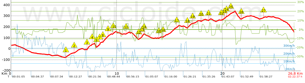
Distance in Km: 26.81
Climb in m: 781
IBP: 61 BYC

eskirol
Author: eskirol
220 published routes

Add to my Group or Club

 Height in m      Climb in %      Speed in Km/h      Speed < 2 Km/h

Climbs > 5%

Climbs >5% Climbs >10% Climbs >15% Climbs >20% Climbs >25%
 Steep slope of 513 m.   Average slope  Distances  Download as waypoint
1
 Km 5.166  7%  513 m
 Steep slope of 324 m.  Average slope  Distances  Download as waypoint
2
 Km 5.986  7%  324 m
 Steep slope of 290 m.  Average slope  Distances  Download as waypoint
3
 Km 7.155  12%  290 m
 Steep slope of 164 m.  Average slope  Distances  Download as waypoint
4
 Km 7.622  6%  164 m
 Steep slope of 404 m.  Average slope  Distances  Download as waypoint
5
 Km 8.081  8%  242 m
6
 Km 8.324  10%  41 m
7
 Km 8.365  15%  121 m
 Steep slope of 700 m.  Average slope  Distances  Download as waypoint
8
 Km 8.653  10%  509 m
9
 Km 9.162  8%  191 m
 Steep slope of 234 m.  Average slope  Distances  Download as waypoint
10
 Km 9.622  9%  234 m
 Steep slope of 234 m.  Average slope  Distances  Download as waypoint
11
 Km 10.898  7%  234 m
 Steep slope of 521 m.  Average slope  Distances  Download as waypoint
12
 Km 12.06  7%  261 m
13
 Km 12.321  13%  220 m
14
 Km 12.541  7%  40 m
 Steep slope of 185 m.  Average slope  Distances  Download as waypoint
15
 Km 14.003  9%  185 m
 Steep slope of 1147 m.  Average slope  Distances  Download as waypoint
16
 Km 14.33  7%  1147 m
 Steep slope of 244 m.  Average slope  Distances  Download as waypoint
17
 Km 15.633  9%  244 m
 Steep slope of 399 m.  Average slope  Distances  Download as waypoint
18
 Km 16.661  10%  399 m
 Steep slope of 418 m.  Average slope  Distances  Download as waypoint
19
 Km 17.177  5%  418 m
 Steep slope of 268 m.  Average slope  Distances  Download as waypoint
20
 Km 17.969  6%  268 m
 Steep slope of 195 m.  Average slope  Distances  Download as waypoint
21
 Km 18.671  8%  195 m
 Steep slope of 778 m.  Average slope  Distances  Download as waypoint
22
 Km 19.899  6%  286 m
23
 Km 20.185  10%  143 m
24
 Km 20.328  6%  349 m
 Steep slope of 271 m.  Average slope  Distances  Download as waypoint
25
 Km 20.787  5%  271 m
 Steep slope of 222 m.  Average slope  Distances  Download as waypoint
26
 Km 21.759  5%  222 m
 Steep slope of 197 m.  Average slope  Distances  Download as waypoint
27
 Km 23.798  6%  197 m


Description of the route


Presence of ramps


 Climbs  Distance  % of the total  Speed  Your speed would be  Time  Your time would be
   15 - 30%  0.219  0.82  5.33  ?  0:02:28  ?
   10 - 15%  1.433  5.34  6.96  ?  0:12:21  ?
   5 - 10%  6.719  25.07  9.29  ?  0:43:25  ?
   1 - 5%  3.818  14.24  13.24  ?  0:17:18  ?
   Total*  12.189 Km  45.47 %  9.68 Km/h  ? Km/h    1:15:32 h  ? h  
 Flat
   1 - -1%  2.105 Km  7.85 %  16.06 Km/h  ? Km/h    0:07:52 h  ? h  
 Descents
   -1 - -5%  7.336  27.37  18.73  ?  0:23:30  ?
   -5 - -10%  3.53  13.17  16.27  ?  0:13:01  ?
   -10 - -15%  1.259  4.7  16.91  ?  0:04:28  ?
   -15 - -30%  0.386  1.44  9.59  ?  0:02:25  ?
   Total*  12.512 Km  46.68 %  17.3 Km/h  ? Km/h    0:43:24 h  ? h  
* The total has not necessarily coincide with the sum of the partials after correction of errors

How long would it take you?

How long would it take you to cover this route?
There are routes without a valid time information, but with your average stats you can assess the possible duration

eskirol to cover this route you've need a time of:   2:06:48 h 
If you sign in and have a minimum of two tracks of this same modality, you can know your time for this route, calculated from your stats..


¿Cuanto consumirá tu E-BIKE?

Entra tu E-IBP (formato n,nn)

E-IBP :   X 61 = 


 Detected activity type =  ()
 Penalization due to track conditions: 76 %   ( > 50 % = MTB, < 50 % = RDB)
 Reliability of the track: C   (879/51/1/16/-/71)
 Correction level applied to the track: 1        See analyis without corrections
DIFFICULTY OF THE ROUTE
IBP = 61 BYC
According to your statistics
 Your time in motion would be: ? h
Your average speed would be: ? Km/h
 

 Total Distance: 26.81 Km
 Analysed distance: 26.81 Km
 Linear distance: 2.87 Km

 Cumulated positive ramps: 780.52 m  list of points info
 Cumulated negative ramps: 662.09 m
 Maximum height: 345.04 m
 Minimum height: -79.74 m
 Climbing Ratio: 6.4 %
 Descent ratio: 5.29 %
 Cumulated postive ramps per Km: 29.11 m
 Cumulated negative ramps per Km: 24.7 m

 Total time: 2:22:37 h
 Time in movement: 2:06:48 h
 According to your statistics
 Your time in motion would be: ? h  
 Stopped time: 0:15:49 h
 Maximum slope filter: ~30 %
 Minimum separation analysed: ~30 m
 Number of points: 1561   (cad. 17.17 m)
 Significant waypoints: 680   (cad. 39.42 m / 43.56 %)

 Changes in direction per Km: 11.04
 Changes in direction > 5º por Km: 9.03
 Cumulated straight stretches: 3.236 Km
 Straight stretches per Km: 120.7 m
 Penalized slope changes: 6
 Penalized slope changes per Km: 0.224

 Average speed in total: 11.28 Km/h
 Average speed while moving: 12.69 Km/h
 According to your statistics
 Your average speed would be: ? Km/h  
 Maximum sustained speed: 46.81 Km/h


Comments

You can be the first one in commenting this route

 
My comments
:
Add comment  (Registered users)
 
Notify me answers to my comment  Do not notify answers to my comment


Share this route with a friend

Your friend will receive a message with a link to this page:
will see your email and your user name if you do it as registered user.


Write here your name (optional)

E-mail address of your friend(s). You can include various addresses separated by commas

Text or comment (optional) maximum 255 characters long, 255 Available characters

As a non registered users you need to fill-in the captcha text.
  Change image
Type the image characters.
 
 Share with a friend


Visited history

Delete history

Marked routes for review later or compare

My favorites


  Notify anomaly in this route Share in Facebook