Vértice Tormo - Pico Gallatillas

Running
Running
Ref..: 883269
Published: 03/07/2020
Performed: 03/07/2020
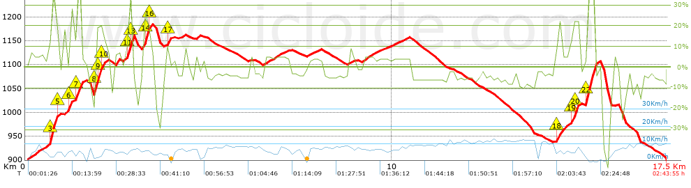
Distance in Km: 17.51
Climb in m: 705
IBP: 140 RNG


 Height in m      Climb in %      Speed in Km/h      Speed < 2 Km/h

Climbs > 5%

Climbs >5% Climbs >10% Climbs >15% Climbs >20% Climbs >25%
 Steep slope of 335 m.   Average slope  Distances  Download as waypoint
1
 Km 0.098  5%  335 m
 Steep slope of 332 m.  Average slope  Distances  Download as waypoint
2
 Km 0.606  7%  31 m
3
 Km 0.636  12%  32 m
4
 Km 0.668  23%  35 m
5
 Km 0.703  32%  135 m
6
 Km 0.838  19%  31 m
7
 Km 0.869  11%  37 m
8
 Km 0.906  8%  31 m
 Steep slope of 198 m.  Average slope  Distances  Download as waypoint
9
 Km 1.031  10%  166 m
10
 Km 1.197  20%  32 m
 Steep slope of 199 m.  Average slope  Distances  Download as waypoint
11
 Km 1.328  8%  65 m
12
 Km 1.393  33%  102 m
13
 Km 1.495  7%  32 m
 Steep slope of 381 m.  Average slope  Distances  Download as waypoint
14
 Km 1.87  25%  138 m
15
 Km 2.008  20%  102 m
16
 Km 2.11  16%  71 m
17
 Km 2.182  8%  70 m
 Steep slope of 137 m.  Average slope  Distances  Download as waypoint
18
 Km 2.424  10%  137 m
 Steep slope of 242 m.  Average slope  Distances  Download as waypoint
19
 Km 2.667  7%  100 m
20
 Km 2.767  17%  68 m
21
 Km 2.835  33%  36 m
22
 Km 2.871  45%  38 m
 Steep slope of 279 m.  Average slope  Distances  Download as waypoint
23
 Km 3.191  9%  34 m
24
 Km 3.225  30%  107 m
25
 Km 3.332  19%  34 m
26
 Km 3.366  13%  36 m
27
 Km 3.402  8%  68 m
 Steep slope of 129 m.  Average slope  Distances  Download as waypoint
28
 Km 3.82  10%  30 m
29
 Km 3.85  14%  99 m
 Steep slope of 301 m.  Average slope  Distances  Download as waypoint
30
 Km 9.176  5%  301 m
 Steep slope of 689 m.  Average slope  Distances  Download as waypoint
31
 Km 14.417  5%  67 m
32
 Km 14.484  14%  174 m
33
 Km 14.658  5%  173 m
34
 Km 14.831  10%  105 m
35
 Km 14.935  23%  135 m
36
 Km 15.071  10%  35 m
 Steep slope of 253 m.  Average slope  Distances  Download as waypoint
37
 Km 15.275  11%  35 m
38
 Km 15.311  39%  218 m
 Steep slope of 33 m.  Average slope  Distances  Download as waypoint
39
 Km 15.558  11%  33 m


Description of the route


Presence of ramps


 Climbs  Distance  % of the total  Speed  Your speed would be  Time  Your time would be
   15 - 30%  0.881  5.02  5.28  ?  0:10:01  ?
   10 - 15%  0.787  4.49  5.63  ?  0:08:23  ?
   5 - 10%  1.48  8.44  6.77  ?  0:13:07  ?
   1 - 5%  3.377  19.26  6.69  ?  0:30:18  ?
   Total*  7.029 Km  40.08 %  5.74 Km/h  ? Km/h    1:13:31 h  ? h  
 Flat
   1 - -1%  0.662 Km  3.77 %  4.56 Km/h  ? Km/h    0:08:43 h  ? h  
 Descents
   -1 - -5%  4.788  27.31  8.17  ?  0:35:09  ?
   -5 - -10%  3.757  21.43  9.98  ?  0:22:36  ?
   -10 - -15%  0.404  2.31  8.32  ?  0:02:55  ?
   -15 - -30%  0.732  4.18  6.08  ?  0:07:14  ?
   Total*  9.845 Km  56.14 %  8.01 Km/h  ? Km/h    1:13:44 h  ? h  
* The total has not necessarily coincide with the sum of the partials after correction of errors

How long would it take you?

How long would it take you to cover this route?
There are routes without a valid time information, but with your average stats you can assess the possible duration

Roberto Rodrigo Perez to cover this route you've need a time of:   2:35:58 h 
If you sign in and have a minimum of two tracks of this same modality, you can know your time for this route, calculated from your stats..


 Detected activity type =  ()
 Penalization due to track conditions: 0 %   ( > 50 % = MTB, < 50 % = RDB)
 Reliability of the track: B   (705/66/0/-/-/66)
 Correction level applied to the track: 0
DIFFICULTY OF THE ROUTE
IBP = 140 RNG
According to your statistics
 Your time in motion would be: ? h
Your average speed would be: ? Km/h
 

 Total Distance: 17.54 Km
 Analysed distance: 17.54 Km
 Linear distance: 0.04 Km

 Cumulated positive ramps: 705 m  list of points info
 Cumulated negative ramps: 703.6 m
 Maximum height: 1183.8 m
 Minimum height: 900 m
 Climbing Ratio: 10.03 %
 Descent ratio: 7.15 %
 Cumulated postive ramps per Km: 40.19 m
 Cumulated negative ramps per Km: 40.11 m

 Total time: 2:43:55 h
 Time in movement: 2:35:58 h
 According to your statistics
 Your time in motion would be: ? h  
 Stopped time: 0:07:57 h
 Maximum slope filter: ~55 %
 Minimum separation analysed: ~30 m
 Number of points: 1543   (cad. 11.36 m)
 Significant waypoints: 514   (cad. 34.12 m / 33.31 %)

 Changes in direction per Km: 14.54
 Changes in direction > 5º por Km: 10.09
 Cumulated straight stretches: 3.162 Km
 Straight stretches per Km: 180.27 m
 Penalized slope changes: 6
 Penalized slope changes per Km: 0.342

 Average speed in total: 6.42 Km/h
 Average speed while moving: 6.75 Km/h
 According to your statistics
 Your average speed would be: ? Km/h  
 Maximum sustained speed: 14.56 Km/h


Comments

You can be the first one in commenting this route

 
My comments
:
Add comment  (Registered users)
 
Notify me answers to my comment  Do not notify answers to my comment


Share this route with a friend

Your friend will receive a message with a link to this page:
will see your email and your user name if you do it as registered user.


Write here your name (optional)

E-mail address of your friend(s). You can include various addresses separated by commas

Text or comment (optional) maximum 255 characters long, 255 Available characters

As a non registered users you need to fill-in the captcha text.
  Change image
Type the image characters.
 
 Share with a friend


Visited history

Delete history

Marked routes for review later or compare

My favorites


  Notify anomaly in this route Share in Facebook