Entrenamiento a la hora del almuerzo Track

MTB
MTB
Ref..: 880944
Published: 25/06/2020
Performed: 25/06/2020
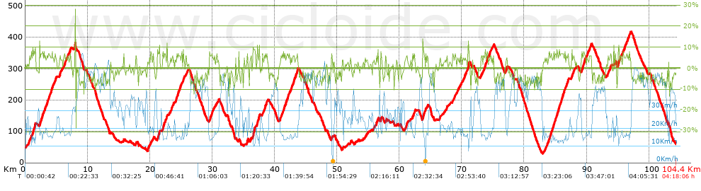
Distance in Km: 104.39
Climb in m: 2179
IBP: 134 BYC

Javi Mora
Author: Javi Mora
256 published routes

Add to my Group or Club

 Height in m      Climb in %      Speed in Km/h      Speed < 2 Km/h

Climbs > 5%

Climbs >5% Climbs >10% Climbs >15% Climbs >20% Climbs >25%
 Steep slope of 482 m.   Average slope  Distances  Download as waypoint
1
 Km 1.186  7%  482 m
 Steep slope of 519 m.  Average slope  Distances  Download as waypoint
2
 Km 2.328  7%  519 m
 Steep slope of 256 m.  Average slope  Distances  Download as waypoint
3
 Km 2.97  6%  256 m
 Steep slope of 352 m.  Average slope  Distances  Download as waypoint
4
 Km 3.548  7%  352 m
 Steep slope of 400 m.  Average slope  Distances  Download as waypoint
5
 Km 4.042  6%  400 m
 Steep slope of 221 m.  Average slope  Distances  Download as waypoint
6
 Km 4.729  6%  221 m
 Steep slope of 161 m.  Average slope  Distances  Download as waypoint
7
 Km 5.565  6%  161 m
 Steep slope of 260 m.  Average slope  Distances  Download as waypoint
8
 Km 6.238  6%  260 m
 Steep slope of 149 m.  Average slope  Distances  Download as waypoint
9
 Km 6.801  6%  149 m
 Steep slope of 210 m.  Average slope  Distances  Download as waypoint
10
 Km 7.086  6%  210 m
 Steep slope of 100 m.  Average slope  Distances  Download as waypoint
11
 Km 20.084  5%  100 m
 Steep slope of 107 m.  Average slope  Distances  Download as waypoint
12
 Km 20.482  7%  107 m
 Steep slope of 309 m.  Average slope  Distances  Download as waypoint
13
 Km 21.239  6%  309 m
 Steep slope of 345 m.  Average slope  Distances  Download as waypoint
14
 Km 21.975  6%  345 m
 Steep slope of 158 m.  Average slope  Distances  Download as waypoint
15
 Km 22.423  6%  158 m
 Steep slope of 228 m.  Average slope  Distances  Download as waypoint
16
 Km 23.495  6%  228 m
 Steep slope of 413 m.  Average slope  Distances  Download as waypoint
17
 Km 24.157  6%  413 m
 Steep slope of 254 m.  Average slope  Distances  Download as waypoint
18
 Km 24.741  6%  254 m
 Steep slope of 224 m.  Average slope  Distances  Download as waypoint
19
 Km 25.325  7%  224 m
 Steep slope of 215 m.  Average slope  Distances  Download as waypoint
20
 Km 25.735  5%  215 m
 Steep slope of 528 m.  Average slope  Distances  Download as waypoint
21
 Km 29.543  6%  528 m
 Steep slope of 182 m.  Average slope  Distances  Download as waypoint
22
 Km 35.56  8%  182 m
 Steep slope of 100 m.  Average slope  Distances  Download as waypoint
23
 Km 36.12  5%  100 m
 Steep slope of 400 m.  Average slope  Distances  Download as waypoint
24
 Km 36.528  8%  400 m
 Steep slope of 332 m.  Average slope  Distances  Download as waypoint
25
 Km 37.212  8%  332 m
 Steep slope of 418 m.  Average slope  Distances  Download as waypoint
26
 Km 38.192  6%  418 m
 Steep slope of 168 m.  Average slope  Distances  Download as waypoint
27
 Km 40.855  5%  168 m
 Steep slope of 491 m.  Average slope  Distances  Download as waypoint
28
 Km 41.136  6%  491 m
 Steep slope of 647 m.  Average slope  Distances  Download as waypoint
29
 Km 41.77  6%  647 m
 Steep slope of 192 m.  Average slope  Distances  Download as waypoint
30
 Km 42.571  6%  192 m
 Steep slope of 437 m.  Average slope  Distances  Download as waypoint
31
 Km 42.933  6%  437 m
 Steep slope of 267 m.  Average slope  Distances  Download as waypoint
32
 Km 43.48  7%  267 m
 Steep slope of 103 m.  Average slope  Distances  Download as waypoint
33
 Km 50.873  6%  103 m
 Steep slope of 141 m.  Average slope  Distances  Download as waypoint
34
 Km 52.105  5%  141 m
 Steep slope of 258 m.  Average slope  Distances  Download as waypoint
35
 Km 56.271  6%  258 m
 Steep slope of 127 m.  Average slope  Distances  Download as waypoint
36
 Km 56.983  6%  127 m
 Steep slope of 147 m.  Average slope  Distances  Download as waypoint
37
 Km 57.748  6%  147 m
 Steep slope of 201 m.  Average slope  Distances  Download as waypoint
38
 Km 60.894  5%  201 m
 Steep slope of 357 m.  Average slope  Distances  Download as waypoint
39
 Km 62.099  6%  357 m
 Steep slope of 337 m.  Average slope  Distances  Download as waypoint
40
 Km 63.723  7%  337 m
 Steep slope of 108 m.  Average slope  Distances  Download as waypoint
41
 Km 67.557  8%  108 m
 Steep slope of 115 m.  Average slope  Distances  Download as waypoint
42
 Km 68.885  6%  115 m
 Steep slope of 172 m.  Average slope  Distances  Download as waypoint
43
 Km 70.361  5%  172 m
 Steep slope of 262 m.  Average slope  Distances  Download as waypoint
44
 Km 70.88  5%  117 m
45
 Km 70.997  11%  104 m
46
 Km 71.101  10%  41 m
 Steep slope of 164 m.  Average slope  Distances  Download as waypoint
47
 Km 73.093  6%  164 m
 Steep slope of 200 m.  Average slope  Distances  Download as waypoint
48
 Km 73.676  7%  200 m
 Steep slope of 230 m.  Average slope  Distances  Download as waypoint
49
 Km 74.011  7%  230 m
 Steep slope of 139 m.  Average slope  Distances  Download as waypoint
50
 Km 74.37  5%  139 m
 Steep slope of 113 m.  Average slope  Distances  Download as waypoint
51
 Km 75.023  6%  113 m
 Steep slope of 240 m.  Average slope  Distances  Download as waypoint
52
 Km 76.956  6%  240 m
 Steep slope of 242 m.  Average slope  Distances  Download as waypoint
53
 Km 83.575  5%  242 m
 Steep slope of 805 m.  Average slope  Distances  Download as waypoint
54
 Km 83.949  6%  805 m
 Steep slope of 444 m.  Average slope  Distances  Download as waypoint
55
 Km 84.886  6%  444 m
 Steep slope of 1111 m.  Average slope  Distances  Download as waypoint
56
 Km 85.453  6%  1111 m
 Steep slope of 327 m.  Average slope  Distances  Download as waypoint
57
 Km 86.715  6%  327 m
 Steep slope of 409 m.  Average slope  Distances  Download as waypoint
58
 Km 87.592  6%  409 m
 Steep slope of 647 m.  Average slope  Distances  Download as waypoint
59
 Km 89.181  6%  647 m
 Steep slope of 191 m.  Average slope  Distances  Download as waypoint
60
 Km 89.989  6%  191 m
 Steep slope of 334 m.  Average slope  Distances  Download as waypoint
61
 Km 90.422  6%  334 m
 Steep slope of 144 m.  Average slope  Distances  Download as waypoint
62
 Km 93.406  7%  144 m
 Steep slope of 133 m.  Average slope  Distances  Download as waypoint
63
 Km 93.715  5%  133 m
 Steep slope of 105 m.  Average slope  Distances  Download as waypoint
64
 Km 94.555  8%  105 m
 Steep slope of 499 m.  Average slope  Distances  Download as waypoint
65
 Km 95.02  7%  499 m
 Steep slope of 284 m.  Average slope  Distances  Download as waypoint
66
 Km 95.772  6%  284 m
 Steep slope of 234 m.  Average slope  Distances  Download as waypoint
67
 Km 96.396  6%  234 m
 Steep slope of 194 m.  Average slope  Distances  Download as waypoint
68
 Km 96.757  6%  194 m


Description of the route


Presence of ramps


 Climbs  Distance  % of the total  Speed  Your speed would be  Time  Your time would be
   15 - 30%  0.113  0.11  19.3  ?  0:00:21  ?
   10 - 15%  0.731  0.7  13.02  ?  0:03:22  ?
   5 - 10%  20.542  19.68  16.45  ?  1:14:55  ?
   1 - 5%  24.01  23  19.82  ?  1:12:41  ?
   Total*  45.396 Km  43.49 %  18 Km/h  ? Km/h    2:31:19 h  ? h  
 Flat
   1 - -1%  14.628 Km  14.01 %  27.37 Km/h  ? Km/h    0:32:04 h  ? h  
 Descents
   -1 - -5%  23.888  22.88  38.6  ?  0:37:08  ?
   -5 - -10%  19.252  18.44  44.8  ?  0:25:47  ?
   -10 - -15%  1.155  1.11  37.13  ?  0:01:52  ?
   -15 - -30%  0.068  0.07  35.13  ?  0:00:07  ?
   Total*  44.363 Km  42.5 %  41.01 Km/h  ? Km/h    1:04:54 h  ? h  
* The total has not necessarily coincide with the sum of the partials after correction of errors

How long would it take you?

How long would it take you to cover this route?
There are routes without a valid time information, but with your average stats you can assess the possible duration

Javi Mora to cover this route you've need a time of:   4:08:17 h 
If you sign in and have a minimum of two tracks of this same modality, you can know your time for this route, calculated from your stats..


¿Cuanto consumirá tu E-BIKE?

Entra tu E-IBP (formato n,nn)

E-IBP :   X 134 = 


 Detected activity type =  ()
 Penalization due to track conditions: 54 %   ( > 50 % = MTB, < 50 % = RDB)
 Reliability of the track: A   (2192/85/0/-/-/85)
 Correction level applied to the track: 0
DIFFICULTY OF THE ROUTE
IBP = 134 BYC
According to your statistics
 Your time in motion would be: ? h
Your average speed would be: ? Km/h
 

 Total Distance: 104.39 Km
 Analysed distance: 104.39 Km
 Linear distance: 0.03 Km

 Cumulated positive ramps: 2178.64 m  list of points info
 Cumulated negative ramps: 2162.44 m
 Maximum height: 418.2 m
 Minimum height: 29 m
 Climbing Ratio: 4.8 %
 Descent ratio: 4.87 %
 Cumulated postive ramps per Km: 20.87 m
 Cumulated negative ramps per Km: 20.72 m

 Total time: 4:18:06 h
 Time in movement: 4:08:17 h
 According to your statistics
 Your time in motion would be: ? h  
 Stopped time: 0:09:49 h
 Maximum slope filter: ~30 %
 Minimum separation analysed: ~30 m
 Number of points: 4374   (cad. 23.87 m)
 Significant waypoints: 2367   (cad. 44.1 m / 54.12 %)

 Changes in direction per Km: 8.42
 Changes in direction > 5º por Km: 6.52
 Cumulated straight stretches: 21.532 Km
 Straight stretches per Km: 206.26 m
 Penalized slope changes: 20
 Penalized slope changes per Km: 0.192

 Average speed in total: 24.27 Km/h
 Average speed while moving: 25.23 Km/h
 According to your statistics
 Your average speed would be: ? Km/h  
 Maximum sustained speed: 64.59 Km/h


Comments

You can be the first one in commenting this route

 
My comments
:
Add comment  (Registered users)
 
Notify me answers to my comment  Do not notify answers to my comment


Share this route with a friend

Your friend will receive a message with a link to this page:
will see your email and your user name if you do it as registered user.


Write here your name (optional)

E-mail address of your friend(s). You can include various addresses separated by commas

Text or comment (optional) maximum 255 characters long, 255 Available characters

As a non registered users you need to fill-in the captcha text.
  Change image
Type the image characters.
 
 Share with a friend


Visited history

Delete history

Marked routes for review later or compare

My favorites


  Notify anomaly in this route Share in Facebook