Taburno da scoprire

MTB
MTB
Ref..: 875417
Published: 06/06/2020
Performed: 06/06/2020
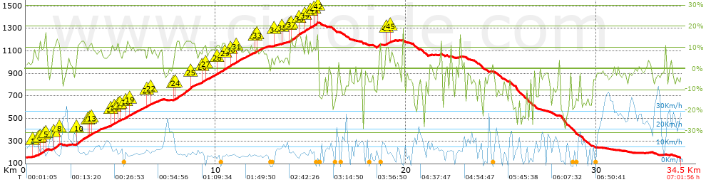
Distance in Km: 34.51
Climb in m: 1406
IBP: 116 BYC

diesse76
Author: diesse76
406 published routes

Add to my Group or Club

 Height in m      Climb in %      Speed in Km/h      Speed < 2 Km/h

Climbs > 5%

Climbs >5% Climbs >10% Climbs >15% Climbs >20% Climbs >25%
 Steep slope of 167 m.   Average slope  Distances  Download as waypoint
1
 Km 0.389  7%  167 m
 Steep slope of 440 m.  Average slope  Distances  Download as waypoint
2
 Km 0.681  12%  112 m
3
 Km 0.793  9%  151 m
4
 Km 0.944  14%  145 m
5
 Km 1.089  10%  32 m
 Steep slope of 391 m.  Average slope  Distances  Download as waypoint
6
 Km 1.434  9%  39 m
7
 Km 1.473  13%  312 m
8
 Km 1.785  8%  40 m
 Steep slope of 3612 m.  Average slope  Distances  Download as waypoint
9
 Km 2.653  7%  36 m
10
 Km 2.689  12%  528 m
11
 Km 3.217  9%  112 m
12
 Km 3.329  11%  151 m
13
 Km 3.48  7%  1019 m
14
 Km 4.499  11%  136 m
15
 Km 4.636  9%  185 m
16
 Km 4.821  10%  138 m
17
 Km 4.959  7%  339 m
18
 Km 5.298  11%  180 m
19
 Km 5.478  9%  788 m
 Steep slope of 779 m.  Average slope  Distances  Download as waypoint
20
 Km 6.375  8%  40 m
21
 Km 6.415  11%  187 m
22
 Km 6.601  7%  552 m
 Steep slope of 4865 m.  Average slope  Distances  Download as waypoint
23
 Km 7.791  7%  82 m
24
 Km 7.873  12%  838 m
25
 Km 8.711  8%  549 m
26
 Km 9.259  11%  241 m
27
 Km 9.5  9%  538 m
28
 Km 10.038  11%  419 m
29
 Km 10.458  10%  349 m
30
 Km 10.807  10%  293 m
31
 Km 11.099  9%  951 m
32
 Km 12.05  10%  116 m
33
 Km 12.166  8%  489 m
 Steep slope of 165 m.  Average slope  Distances  Download as waypoint
34
 Km 13.094  5%  165 m
 Steep slope of 194 m.  Average slope  Distances  Download as waypoint
35
 Km 13.509  5%  194 m
 Steep slope of 1505 m.  Average slope  Distances  Download as waypoint
36
 Km 13.859  9%  83 m
37
 Km 13.942  13%  465 m
38
 Km 14.407  10%  296 m
39
 Km 14.703  12%  210 m
40
 Km 14.913  10%  255 m
41
 Km 15.168  14%  163 m
42
 Km 15.331  16%  33 m
 Steep slope of 344 m.  Average slope  Distances  Download as waypoint
43
 Km 18.917  10%  42 m
44
 Km 18.959  12%  161 m
45
 Km 19.12  6%  141 m


Description of the route


Presence of ramps


 Climbs  Distance  % of the total  Speed  Your speed would be  Time  Your time would be
   15 - 30%  0.511  1.48  6.82  ?  0:04:30  ?
   10 - 15%  5.283  15.31  7.33  ?  0:43:14  ?
   5 - 10%  7.542  21.85  7.82  ?  0:57:52  ?
   1 - 5%  3.585  10.39  10.96  ?  0:19:37  ?
   Total*  16.921 Km  49.03 %  8.11 Km/h  ? Km/h    2:05:13 h  ? h  
 Flat
   1 - -1%  2.25 Km  6.52 %  12.05 Km/h  ? Km/h    0:11:12 h  ? h  
 Descents
   -1 - -5%  5.918  17.15  13.33  ?  0:26:38  ?
   -5 - -10%  3.743  10.85  11.87  ?  0:18:55  ?
   -10 - -15%  2.431  7.04  11.36  ?  0:12:50  ?
   -15 - -30%  3.248  9.41  6.68  ?  0:29:11  ?
   Total*  15.34 Km  44.45 %  10.51 Km/h  ? Km/h    1:27:34 h  ? h  
* The total has not necessarily coincide with the sum of the partials after correction of errors

How long would it take you?

How long would it take you to cover this route?
There are routes without a valid time information, but with your average stats you can assess the possible duration

diesse76 to cover this route you've need a time of:   3:43:59 h 
If you sign in and have a minimum of two tracks of this same modality, you can know your time for this route, calculated from your stats..


¿Cuanto consumirá tu E-BIKE?

Entra tu E-IBP (formato n,nn)

E-IBP :   X 116 = 


 Detected activity type =  ()
 Penalization due to track conditions: 74 %   ( > 50 % = MTB, < 50 % = RDB)
 Reliability of the track: A   (1406/77/0/-/-/77)
 Correction level applied to the track: 0
DIFFICULTY OF THE ROUTE
IBP = 116 BYC
According to your statistics
 Your time in motion would be: ? h
Your average speed would be: ? Km/h
 

 Total Distance: 34.51 Km
 Analysed distance: 34.51 Km
 Linear distance: 0.01 Km

 Cumulated positive ramps: 1405.6 m  list of points info
 Cumulated negative ramps: 1408.6 m
 Maximum height: 1354 m
 Minimum height: 149 m
 Climbing Ratio: 8.31 %
 Descent ratio: 9.18 %
 Cumulated postive ramps per Km: 40.73 m
 Cumulated negative ramps per Km: 40.82 m

 Total time: 7:01:56 h
 Time in movement: 3:43:59 h
 According to your statistics
 Your time in motion would be: ? h  
 Stopped time: 3:17:57 h
 Maximum slope filter: ~30 %
 Minimum separation analysed: ~30 m
 Number of points: 1972   (cad. 17.5 m)
 Significant waypoints: 866   (cad. 39.85 m / 43.91 %)

 Changes in direction per Km: 10.46
 Changes in direction > 5º por Km: 7.33
 Cumulated straight stretches: 5.061 Km
 Straight stretches per Km: 146.65 m
 Penalized slope changes: 9
 Penalized slope changes per Km: 0.261

 Average speed in total: 4.91 Km/h
 Average speed while moving: 9.24 Km/h
 According to your statistics
 Your average speed would be: ? Km/h  
 Maximum sustained speed: 45.57 Km/h


Comments

You can be the first one in commenting this route

 
My comments
:
Add comment  (Registered users)
 
Notify me answers to my comment  Do not notify answers to my comment


Share this route with a friend

Your friend will receive a message with a link to this page:
will see your email and your user name if you do it as registered user.


Write here your name (optional)

E-mail address of your friend(s). You can include various addresses separated by commas

Text or comment (optional) maximum 255 characters long, 255 Available characters

As a non registered users you need to fill-in the captcha text.
  Change image
Type the image characters.
 
 Share with a friend


Visited history

Delete history

Marked routes for review later or compare

My favorites


  Notify anomaly in this route Share in Facebook