2020 06 02 cajarfrontilinagron

Road
Road
Ref..: 874558
Published: 03/06/2020
Performed: 02/06/2020
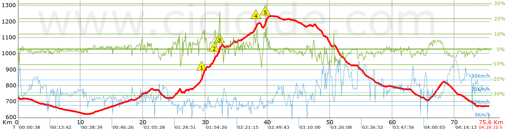
Distance in Km: 75.63
Climb in m: 948
IBP: 64 BYC


 Height in m      Climb in %      Speed in Km/h      Speed < 2 Km/h

Climbs > 5%

Climbs >5% Climbs >10% Climbs >15% Climbs >20% Climbs >25%
 Steep slope of 175 m.   Average slope  Distances  Download as waypoint
1
 Km 19.755  7%  175 m
 Steep slope of 103 m.  Average slope  Distances  Download as waypoint
2
 Km 24.881  5%  103 m
 Steep slope of 201 m.  Average slope  Distances  Download as waypoint
3
 Km 25.47  6%  201 m
 Steep slope of 104 m.  Average slope  Distances  Download as waypoint
4
 Km 25.844  13%  104 m
 Steep slope of 113 m.  Average slope  Distances  Download as waypoint
5
 Km 26.812  9%  113 m
 Steep slope of 115 m.  Average slope  Distances  Download as waypoint
6
 Km 28.772  7%  115 m
 Steep slope of 100 m.  Average slope  Distances  Download as waypoint
7
 Km 28.991  6%  100 m
 Steep slope of 957 m.  Average slope  Distances  Download as waypoint
8
 Km 29.195  7%  311 m
9
 Km 29.505  12%  240 m
10
 Km 29.745  9%  406 m
 Steep slope of 163 m.  Average slope  Distances  Download as waypoint
11
 Km 30.75  5%  163 m
 Steep slope of 489 m.  Average slope  Distances  Download as waypoint
12
 Km 31.196  7%  318 m
13
 Km 31.514  12%  171 m
 Steep slope of 218 m.  Average slope  Distances  Download as waypoint
14
 Km 31.898  7%  218 m
 Steep slope of 307 m.  Average slope  Distances  Download as waypoint
15
 Km 32.213  8%  32 m
16
 Km 32.246  19%  141 m
17
 Km 32.387  6%  134 m
 Steep slope of 116 m.  Average slope  Distances  Download as waypoint
18
 Km 34.542  7%  116 m
 Steep slope of 104 m.  Average slope  Distances  Download as waypoint
19
 Km 35.206  7%  104 m
 Steep slope of 573 m.  Average slope  Distances  Download as waypoint
20
 Km 37.743  7%  470 m
21
 Km 38.213  13%  103 m
 Steep slope of 630 m.  Average slope  Distances  Download as waypoint
22
 Km 39.414  9%  272 m
23
 Km 39.686  15%  144 m
24
 Km 39.83  5%  214 m
 Steep slope of 140 m.  Average slope  Distances  Download as waypoint
25
 Km 47.346  6%  140 m
 Steep slope of 128 m.  Average slope  Distances  Download as waypoint
26
 Km 66.533  6%  128 m
 Steep slope of 375 m.  Average slope  Distances  Download as waypoint
27
 Km 66.757  6%  375 m
 Steep slope of 627 m.  Average slope  Distances  Download as waypoint
28
 Km 67.258  6%  627 m


Description of the route


Presence of ramps


 Climbs  Distance  % of the total  Speed  Your speed would be  Time  Your time would be
   15 - 30%  0.25  0.33  10.58  ?  0:01:25  ?
   10 - 15%  0.965  1.28  9.98  ?  0:05:48  ?
   5 - 10%  5.447  7.2  11.79  ?  0:27:43  ?
   1 - 5%  16.745  22.14  13.54  ?  1:14:12  ?
   Total*  23.407 Km  30.95 %  12.87 Km/h  ? Km/h    1:49:08 h  ? h  
 Flat
   1 - -1%  22.137 Km  29.27 %  18.64 Km/h  ? Km/h    1:11:15 h  ? h  
 Descents
   -1 - -5%  25.107  33.2  23.52  ?  1:04:03  ?
   -5 - -10%  4.841  6.4  26.33  ?  0:11:02  ?
   -10 - -15%  0.138  0.18  10.32  ?  0:00:48  ?
   -15 - -30%  0  0  0  ?  0:00:00  ?
   Total*  30.086 Km  39.78 %  23.79 Km/h  ? Km/h    1:15:53 h  ? h  
* The total has not necessarily coincide with the sum of the partials after correction of errors

How long would it take you?

How long would it take you to cover this route?
There are routes without a valid time information, but with your average stats you can assess the possible duration

Armando_Rodriguez_Nieto to cover this route you've need a time of:   4:16:16 h 
If you sign in and have a minimum of two tracks of this same modality, you can know your time for this route, calculated from your stats..


¿Cuanto consumirá tu E-BIKE?

Entra tu E-IBP (formato n,nn)

E-IBP :   X 64 = 


 Detected activity type =  ()
 Penalization due to track conditions: 36 %   ( > 50 % = MTB, < 50 % = RDB)
 Reliability of the track: A   (948/73/0/-/-/73)
 Correction level applied to the track: 0
DIFFICULTY OF THE ROUTE
IBP = 64 BYC
According to your statistics
 Your time in motion would be: ? h
Your average speed would be: ? Km/h
 

 Total Distance: 75.63 Km
 Analysed distance: 75.63 Km
 Linear distance: 6.33 Km

 Cumulated positive ramps: 948.2 m  list of points info
 Cumulated negative ramps: 978.1 m
 Maximum height: 1234.2 m
 Minimum height: 620.9 m
 Climbing Ratio: 4.05 %
 Descent ratio: 3.25 %
 Cumulated postive ramps per Km: 12.54 m
 Cumulated negative ramps per Km: 12.93 m

 Total time: 4:29:10 h
 Time in movement: 4:16:16 h
 According to your statistics
 Your time in motion would be: ? h  
 Stopped time: 0:12:54 h
 Maximum slope filter: ~30 %
 Minimum separation analysed: ~30 m
 Number of points: 5983   (cad. 12.64 m)
 Significant waypoints: 2132   (cad. 35.47 m / 35.63 %)

 Changes in direction per Km: 10.59
 Changes in direction > 5º por Km: 4.8
 Cumulated straight stretches: 32.827 Km
 Straight stretches per Km: 434.05 m
 Penalized slope changes: 10
 Penalized slope changes per Km: 0.132

 Average speed in total: 16.86 Km/h
 Average speed while moving: 17.71 Km/h
 According to your statistics
 Your average speed would be: ? Km/h  
 Maximum sustained speed: 51.04 Km/h


Comments

You can be the first one in commenting this route

 
My comments
:
Add comment  (Registered users)
 
Notify me answers to my comment  Do not notify answers to my comment


Share this route with a friend

Your friend will receive a message with a link to this page:
will see your email and your user name if you do it as registered user.


Write here your name (optional)

E-mail address of your friend(s). You can include various addresses separated by commas

Text or comment (optional) maximum 255 characters long, 255 Available characters

As a non registered users you need to fill-in the captcha text.
  Change image
Type the image characters.
 
 Share with a friend


Visited history

Delete history

Marked routes for review later or compare

My favorites


  Notify anomaly in this route Share in Facebook