2020 05 26 cajarcerropollocajar

MTB
MTB
Ref..: 872375
Published: 27/05/2020
Performed: 26/05/2020
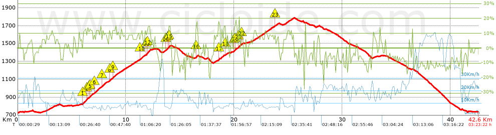
Distance in Km: 42.62
Climb in m: 1612
IBP: 134 BYC


 Height in m      Climb in %      Speed in Km/h      Speed < 2 Km/h

Climbs > 5%

Climbs >5% Climbs >10% Climbs >15% Climbs >20% Climbs >25%
 Steep slope of 104 m.   Average slope  Distances  Download as waypoint
1
 Km 1.222  10%  104 m
 Steep slope of 108 m.  Average slope  Distances  Download as waypoint
2
 Km 2.418  5%  108 m
 Steep slope of 421 m.  Average slope  Distances  Download as waypoint
3
 Km 2.63  7%  421 m
 Steep slope of 235 m.  Average slope  Distances  Download as waypoint
4
 Km 3.149  9%  235 m
 Steep slope of 133 m.  Average slope  Distances  Download as waypoint
5
 Km 3.521  7%  133 m
 Steep slope of 2305 m.  Average slope  Distances  Download as waypoint
6
 Km 5.951  12%  464 m
7
 Km 6.415  12%  101 m
8
 Km 6.516  10%  103 m
9
 Km 6.619  11%  93 m
10
 Km 6.712  12%  170 m
11
 Km 6.882  9%  170 m
12
 Km 7.052  11%  370 m
13
 Km 7.422  9%  342 m
14
 Km 7.764  12%  230 m
15
 Km 7.994  9%  262 m
 Steep slope of 1044 m.  Average slope  Distances  Download as waypoint
16
 Km 8.354  6%  66 m
17
 Km 8.42  12%  166 m
18
 Km 8.585  8%  138 m
19
 Km 8.723  13%  165 m
20
 Km 8.888  10%  509 m
 Steep slope of 1332 m.  Average slope  Distances  Download as waypoint
21
 Km 9.498  8%  1332 m
 Steep slope of 767 m.  Average slope  Distances  Download as waypoint
22
 Km 10.934  7%  368 m
23
 Km 11.302  12%  238 m
24
 Km 11.54  9%  161 m
 Steep slope of 456 m.  Average slope  Distances  Download as waypoint
25
 Km 11.8  9%  67 m
26
 Km 11.867  15%  130 m
27
 Km 11.996  15%  196 m
28
 Km 12.193  11%  63 m
 Steep slope of 98 m.  Average slope  Distances  Download as waypoint
29
 Km 12.395  5%  98 m
 Steep slope of 787 m.  Average slope  Distances  Download as waypoint
30
 Km 13.429  9%  279 m
31
 Km 13.708  11%  205 m
32
 Km 13.913  14%  99 m
33
 Km 14.012  13%  103 m
34
 Km 14.115  9%  101 m
 Steep slope of 231 m.  Average slope  Distances  Download as waypoint
35
 Km 16.422  14%  200 m
36
 Km 16.623  6%  31 m
 Steep slope of 302 m.  Average slope  Distances  Download as waypoint
37
 Km 18.008  5%  302 m
 Steep slope of 234 m.  Average slope  Distances  Download as waypoint
38
 Km 18.415  6%  101 m
39
 Km 18.517  10%  102 m
40
 Km 18.619  16%  31 m
 Steep slope of 404 m.  Average slope  Distances  Download as waypoint
41
 Km 18.778  9%  371 m
42
 Km 19.149  15%  33 m
 Steep slope of 199 m.  Average slope  Distances  Download as waypoint
43
 Km 19.28  8%  199 m
 Steep slope of 100 m.  Average slope  Distances  Download as waypoint
44
 Km 19.655  8%  100 m
 Steep slope of 522 m.  Average slope  Distances  Download as waypoint
45
 Km 19.931  11%  101 m
46
 Km 20.032  10%  357 m
47
 Km 20.389  17%  64 m
 Steep slope of 210 m.  Average slope  Distances  Download as waypoint
48
 Km 20.624  11%  140 m
49
 Km 20.764  9%  70 m
 Steep slope of 131 m.  Average slope  Distances  Download as waypoint
50
 Km 21.042  5%  131 m
 Steep slope of 212 m.  Average slope  Distances  Download as waypoint
51
 Km 21.49  5%  212 m
 Steep slope of 602 m.  Average slope  Distances  Download as waypoint
52
 Km 21.812  8%  602 m
 Steep slope of 1250 m.  Average slope  Distances  Download as waypoint
53
 Km 22.51  9%  1250 m
 Steep slope of 343 m.  Average slope  Distances  Download as waypoint
54
 Km 23.793  9%  65 m
55
 Km 23.858  12%  34 m
56
 Km 23.892  8%  244 m
 Steep slope of 947 m.  Average slope  Distances  Download as waypoint
57
 Km 24.546  8%  947 m
 Steep slope of 141 m.  Average slope  Distances  Download as waypoint
58
 Km 27.592  6%  141 m
 Steep slope of 98 m.  Average slope  Distances  Download as waypoint
59
 Km 32.786  8%  98 m
 Steep slope of 140 m.  Average slope  Distances  Download as waypoint
60
 Km 32.991  5%  140 m
 Steep slope of 152 m.  Average slope  Distances  Download as waypoint
61
 Km 33.428  8%  152 m
 Steep slope of 95 m.  Average slope  Distances  Download as waypoint
62
 Km 40.909  9%  95 m


Description of the route


Presence of ramps


 Climbs  Distance  % of the total  Speed  Your speed would be  Time  Your time would be
   15 - 30%  1.217  2.85  7.89  ?  0:09:15  ?
   10 - 15%  4.354  10.22  8.41  ?  0:31:03  ?
   5 - 10%  10.255  24.06  9.06  ?  1:07:53  ?
   1 - 5%  3.488  8.18  12.25  ?  0:17:05  ?
   Total*  19.313 Km  45.31 %  9.25 Km/h  ? Km/h    2:05:16 h  ? h  
 Flat
   1 - -1%  4.069 Km  9.55 %  15.12 Km/h  ? Km/h    0:16:09 h  ? h  
 Descents
   -1 - -5%  4.001  9.39  18.1  ?  0:13:16  ?
   -5 - -10%  8.994  21.1  18.65  ?  0:28:56  ?
   -10 - -15%  5.051  11.85  27.59  ?  0:10:59  ?
   -15 - -30%  1.193  2.8  18.2  ?  0:03:56  ?
   Total*  19.238 Km  45.14 %  20.21 Km/h  ? Km/h    0:57:07 h  ? h  
* The total has not necessarily coincide with the sum of the partials after correction of errors

How long would it take you?

How long would it take you to cover this route?
There are routes without a valid time information, but with your average stats you can assess the possible duration

Armando_Rodriguez_Nieto to cover this route you've need a time of:   3:18:32 h 
If you sign in and have a minimum of two tracks of this same modality, you can know your time for this route, calculated from your stats..


¿Cuanto consumirá tu E-BIKE?

Entra tu E-IBP (formato n,nn)

E-IBP :   X 134 = 


 Detected activity type =  ()
 Penalization due to track conditions: 81 %   ( > 50 % = MTB, < 50 % = RDB)
 Reliability of the track: B   (1615/71/0/-/-/71)
 Correction level applied to the track: 0
DIFFICULTY OF THE ROUTE
IBP = 134 BYC
According to your statistics
 Your time in motion would be: ? h
Your average speed would be: ? Km/h
 

 Total Distance: 42.62 Km
 Analysed distance: 42.62 Km
 Linear distance: 0.01 Km

 Cumulated positive ramps: 1611.59 m  list of points info
 Cumulated negative ramps: 1603.88 m
 Maximum height: 1786 m
 Minimum height: 726 m
 Climbing Ratio: 8.34 %
 Descent ratio: 8.34 %
 Cumulated postive ramps per Km: 37.81 m
 Cumulated negative ramps per Km: 37.63 m

 Total time: 3:23:22 h
 Time in movement: 3:18:32 h
 According to your statistics
 Your time in motion would be: ? h  
 Stopped time: 0:04:50 h
 Maximum slope filter: ~30 %
 Minimum separation analysed: ~30 m
 Number of points: 3492   (cad. 12.21 m)
 Significant waypoints: 1217   (cad. 35.02 m / 34.85 %)

 Changes in direction per Km: 11.19
 Changes in direction > 5º por Km: 8.61
 Cumulated straight stretches: 8.943 Km
 Straight stretches per Km: 209.83 m
 Penalized slope changes: 11
 Penalized slope changes per Km: 0.258

 Average speed in total: 12.57 Km/h
 Average speed while moving: 12.88 Km/h
 According to your statistics
 Your average speed would be: ? Km/h  
 Maximum sustained speed: 68.16 Km/h


Comments

You can be the first one in commenting this route

 
My comments
:
Add comment  (Registered users)
 
Notify me answers to my comment  Do not notify answers to my comment


Share this route with a friend

Your friend will receive a message with a link to this page:
will see your email and your user name if you do it as registered user.


Write here your name (optional)

E-mail address of your friend(s). You can include various addresses separated by commas

Text or comment (optional) maximum 255 characters long, 255 Available characters

As a non registered users you need to fill-in the captcha text.
  Change image
Type the image characters.
 
 Share with a friend


Visited history

Delete history

Marked routes for review later or compare

My favorites


  Notify anomaly in this route Share in Facebook