8-10 2017 vilanova torredembarra

MTB
MTB
Ref..: 864952
Published: 06/04/2020
Performed: 08/10/2017
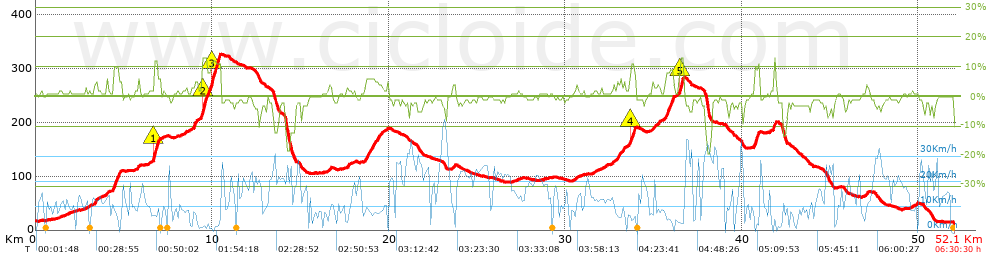
Distance in Km: 52.05
Climb in m: 659
IBP: 50 BYC

Near ...
Barri Maritim De Sant Salvador, Barri Maritim Del Francas, Estacio De Sant Vicenç De Calders (Viviendas), Francas (Camping), Garrofers, Els, Masia Blanca, La
MMorell
Author: MMorell
203 published routes

Add to my Group or Club


Varios dias

This route belongs to a multi-day journey 7 days documented with 7 independent routes

You can download the tracks of this multi-day route from each of the associated stages .
 Day or stage  One day stage  Distance  Climb in  IBP
 Day 1  345214 2017-04-02_0901_LePerthus Borrassa  57 Km  634 m  56
 Day 2  345215 2017-04-30_0938_Figueres Sils  86 Km  481 m  57
 Day 3  864950 sils hostalric  45 Km  952 m  57
 Day 4  686308 2018-01-28 hostalric cardedeu  51 Km  774 m  61
 Day 5  864949 cardedeu cornella  55 Km  263 m  25
 Day 6  864951 cornella vilanova  51 Km  640 m  49
 Day 7  864952 8-10 2017 vilanova torredembarra (This)  52 Km  659 m  50
 Total 7 days  397 Km  4403 m  51 / día

 Height in m      Climb in %      Speed in Km/h      Speed < 2 Km/h

Climbs > 10%

Climbs >5% Climbs >10% Climbs >15% Climbs >20% Climbs >25%
 Steep slope of 211 m.   Average slope  Distances  Download as waypoint
1
 Km 6.694  12%  211 m
 Steep slope of 830 m.  Average slope  Distances  Download as waypoint
2
 Km 9.419  12%  289 m
3
 Km 9.918  11%  541 m
 Steep slope of 211 m.  Average slope  Distances  Download as waypoint
4
 Km 33.688  11%  211 m
 Steep slope of 209 m.  Average slope  Distances  Download as waypoint
5
 Km 36.475  13%  209 m


Description of the route


Presence of ramps


 Climbs  Distance  % of the total  Speed  Your speed would be  Time  Your time would be
   15 - 30%  0  0  0  ?  0:00:00  ?
   10 - 15%  1.544  2.97  4.23  ?  0:21:54  ?
   5 - 10%  3.436  6.6  7.12  ?  0:28:58  ?
   1 - 5%  11.066  21.26  9.33  ?  1:11:10  ?
   Total*  16.046 Km  30.83 %  7.89 Km/h  ? Km/h    2:02:02 h  ? h  
 Flat
   1 - -1%  17.486 Km  33.59 %  11.43 Km/h  ? Km/h    1:31:45 h  ? h  
 Descents
   -1 - -5%  15.364  29.52  14.04  ?  1:05:41  ?
   -5 - -10%  1.811  3.48  19.18  ?  0:05:40  ?
   -10 - -15%  0.864  1.66  10.76  ?  0:04:49  ?
   -15 - -30%  0.481  0.92  22.8  ?  0:01:16  ?
   Total*  18.521 Km  35.58 %  14.35 Km/h  ? Km/h    1:17:26 h  ? h  
* The total has not necessarily coincide with the sum of the partials after correction of errors

How long would it take you?

How long would it take you to cover this route?
There are routes without a valid time information, but with your average stats you can assess the possible duration

MMorell to cover this route you've need a time of:   4:51:13 h 
If you sign in and have a minimum of two tracks of this same modality, you can know your time for this route, calculated from your stats..


¿Cuanto consumirá tu E-BIKE?

Entra tu E-IBP (formato n,nn)

E-IBP :   X 50 = 


 Detected activity type =  ()
 Penalization due to track conditions: 58 %   ( > 50 % = MTB, < 50 % = RDB)
 Reliability of the track: E   (1175/31/2/2/2/80)
 Correction level applied to the track: 7        See analyis without corrections
DIFFICULTY OF THE ROUTE
IBP = 50 BYC
According to your statistics
 Your time in motion would be: ? h
Your average speed would be: ? Km/h
 

 Total Distance: 52.05 Km
 Analysed distance: 52.05 Km
 Linear distance: 28.81 Km

 Cumulated positive ramps: 659.34 m  list of points info
 Cumulated negative ramps: 663.48 m
 Maximum height: 326.49 m
 Minimum height: 10.39 m
 Climbing Ratio: 4.11 %
 Descent ratio: 3.58 %
 Cumulated postive ramps per Km: 12.67 m
 Cumulated negative ramps per Km: 12.75 m

 Total time: 6:30:30 h
 Time in movement: 4:51:13 h
 According to your statistics
 Your time in motion would be: ? h  
 Stopped time: 1:39:17 h
 Maximum slope filter: ~30 %
 Minimum separation analysed: ~30 m
 Number of points: 2350   (cad. 22.15 m)
 Significant waypoints: 1176   (cad. 44.26 m / 50.04 %)

 Changes in direction per Km: 10.22
 Changes in direction > 5º por Km: 7.92
 Cumulated straight stretches: 7.914 Km
 Straight stretches per Km: 152.05 m
 Penalized slope changes: 10
 Penalized slope changes per Km: 0.192

 Average speed in total: 8 Km/h
 Average speed while moving: 10.72 Km/h
 According to your statistics
 Your average speed would be: ? Km/h  
 Maximum sustained speed: 46.36 Km/h


Comments

You can be the first one in commenting this route

 
My comments
:
Add comment  (Registered users)
 
Notify me answers to my comment  Do not notify answers to my comment


Share this route with a friend

Your friend will receive a message with a link to this page:
will see your email and your user name if you do it as registered user.


Write here your name (optional)

E-mail address of your friend(s). You can include various addresses separated by commas

Text or comment (optional) maximum 255 characters long, 255 Available characters

As a non registered users you need to fill-in the captcha text.
  Change image
Type the image characters.
 
 Share with a friend


Visited history

Delete history

Marked routes for review later or compare

My favorites


  Notify anomaly in this route Share in Facebook