Senderos, senderos, senderos

MTB
MTB
Ref..: 864113
Published: 12/03/2020
Performed: 11/03/2020
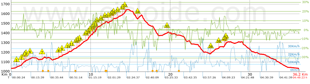
Distance in Km: 36.24
Climb in m: 966
IBP: 72 BYC

AGL
Author: AGL
65 published routes

Add to my Group or Club

 Height in m      Climb in %      Speed in Km/h      Speed < 2 Km/h

Climbs > 5%

Climbs >5% Climbs >10% Climbs >15% Climbs >20% Climbs >25%
 Steep slope of 125 m.   Average slope  Distances  Download as waypoint
1
 Km 0.646  7%  125 m
 Steep slope of 296 m.  Average slope  Distances  Download as waypoint
2
 Km 1.257  10%  296 m
 Steep slope of 202 m.  Average slope  Distances  Download as waypoint
3
 Km 1.691  7%  41 m
4
 Km 1.731  10%  120 m
5
 Km 1.851  13%  41 m
 Steep slope of 151 m.  Average slope  Distances  Download as waypoint
6
 Km 2.384  6%  151 m
 Steep slope of 352 m.  Average slope  Distances  Download as waypoint
7
 Km 3.861  7%  352 m
 Steep slope of 115 m.  Average slope  Distances  Download as waypoint
8
 Km 5.965  9%  115 m
 Steep slope of 111 m.  Average slope  Distances  Download as waypoint
9
 Km 6.373  9%  111 m
 Steep slope of 316 m.  Average slope  Distances  Download as waypoint
10
 Km 7.015  7%  316 m
 Steep slope of 325 m.  Average slope  Distances  Download as waypoint
11
 Km 7.551  7%  325 m
 Steep slope of 100 m.  Average slope  Distances  Download as waypoint
12
 Km 8.123  7%  100 m
 Steep slope of 137 m.  Average slope  Distances  Download as waypoint
13
 Km 8.344  7%  137 m
 Steep slope of 577 m.  Average slope  Distances  Download as waypoint
14
 Km 8.593  8%  577 m
 Steep slope of 619 m.  Average slope  Distances  Download as waypoint
15
 Km 9.347  6%  291 m
16
 Km 9.638  13%  179 m
17
 Km 9.817  11%  149 m
 Steep slope of 230 m.  Average slope  Distances  Download as waypoint
18
 Km 10.17  10%  33 m
19
 Km 10.203  10%  38 m
20
 Km 10.241  17%  110 m
21
 Km 10.351  5%  49 m
 Steep slope of 333 m.  Average slope  Distances  Download as waypoint
22
 Km 10.512  12%  41 m
23
 Km 10.553  18%  254 m
24
 Km 10.807  10%  38 m
 Steep slope of 193 m.  Average slope  Distances  Download as waypoint
25
 Km 11.258  9%  193 m
 Steep slope of 161 m.  Average slope  Distances  Download as waypoint
26
 Km 11.728  9%  161 m
 Steep slope of 154 m.  Average slope  Distances  Download as waypoint
27
 Km 12.188  7%  154 m
 Steep slope of 344 m.  Average slope  Distances  Download as waypoint
28
 Km 12.565  6%  156 m
29
 Km 12.721  11%  116 m
30
 Km 12.838  9%  72 m
 Steep slope of 178 m.  Average slope  Distances  Download as waypoint
31
 Km 13.315  8%  178 m
 Steep slope of 498 m.  Average slope  Distances  Download as waypoint
32
 Km 13.989  9%  274 m
33
 Km 14.264  13%  224 m
 Steep slope of 468 m.  Average slope  Distances  Download as waypoint
34
 Km 15.873  8%  468 m
 Steep slope of 156 m.  Average slope  Distances  Download as waypoint
35
 Km 19.602  5%  156 m
 Steep slope of 592 m.  Average slope  Distances  Download as waypoint
36
 Km 25.054  8%  592 m
 Steep slope of 151 m.  Average slope  Distances  Download as waypoint
37
 Km 26.018  6%  36 m
38
 Km 26.054  12%  115 m
 Steep slope of 386 m.  Average slope  Distances  Download as waypoint
39
 Km 26.719  15%  40 m
40
 Km 26.76  13%  116 m
41
 Km 26.875  14%  80 m
42
 Km 26.955  8%  150 m


Description of the route


Presence of ramps


 Climbs  Distance  % of the total  Speed  Your speed would be  Time  Your time would be
   15 - 30%  0.602  1.66  8.4  ?  0:04:18  ?
   10 - 15%  1.819  5.02  7.68  ?  0:14:13  ?
   5 - 10%  5.702  15.73  8.49  ?  0:40:18  ?
   1 - 5%  8.099  22.35  10.02  ?  0:48:31  ?
   Total*  16.221 Km  44.76 %  9.07 Km/h  ? Km/h    1:47:20 h  ? h  
 Flat
   1 - -1%  4.925 Km  13.59 %  9.91 Km/h  ? Km/h    0:29:49 h  ? h  
 Descents
   -1 - -5%  7.331  20.23  13.43  ?  0:32:45  ?
   -5 - -10%  4.436  12.24  16.67  ?  0:15:58  ?
   -10 - -15%  2.4  6.62  12.38  ?  0:11:38  ?
   -15 - -30%  0.925  2.55  9.52  ?  0:05:50  ?
   Total*  15.093 Km  41.65 %  13.68 Km/h  ? Km/h    1:06:11 h  ? h  
* The total has not necessarily coincide with the sum of the partials after correction of errors

How long would it take you?

How long would it take you to cover this route?
There are routes without a valid time information, but with your average stats you can assess the possible duration

AGL to cover this route you've need a time of:   3:23:20 h 
If you sign in and have a minimum of two tracks of this same modality, you can know your time for this route, calculated from your stats..


¿Cuanto consumirá tu E-BIKE?

Entra tu E-IBP (formato n,nn)

E-IBP :   X 72 = 


 Detected activity type =  ()
 Penalization due to track conditions: 65 %   ( > 50 % = MTB, < 50 % = RDB)
 Reliability of the track: B   (967/71/0/-/-/71)
 Correction level applied to the track: 0
DIFFICULTY OF THE ROUTE
IBP = 72 BYC
According to your statistics
 Your time in motion would be: ? h
Your average speed would be: ? Km/h
 

 Total Distance: 36.24 Km
 Analysed distance: 36.24 Km
 Linear distance: 0.18 Km

 Cumulated positive ramps: 966.3 m  list of points info
 Cumulated negative ramps: 966.7 m
 Maximum height: 1647.3 m
 Minimum height: 1029.3 m
 Climbing Ratio: 5.96 %
 Descent ratio: 6.41 %
 Cumulated postive ramps per Km: 26.66 m
 Cumulated negative ramps per Km: 26.67 m

 Total time: 4:49:23 h
 Time in movement: 3:23:20 h
 According to your statistics
 Your time in motion would be: ? h  
 Stopped time: 1:26:03 h
 Maximum slope filter: ~30 %
 Minimum separation analysed: ~30 m
 Number of points: 2267   (cad. 15.99 m)
 Significant waypoints: 939   (cad. 38.59 m / 41.42 %)

 Changes in direction per Km: 11.59
 Changes in direction > 5º por Km: 8.33
 Cumulated straight stretches: 6.264 Km
 Straight stretches per Km: 172.85 m
 Penalized slope changes: 7
 Penalized slope changes per Km: 0.193

 Average speed in total: 7.51 Km/h
 Average speed while moving: 10.69 Km/h
 According to your statistics
 Your average speed would be: ? Km/h  
 Maximum sustained speed: 45.43 Km/h


Comments

You can be the first one in commenting this route

 
My comments
:
Add comment  (Registered users)
 
Notify me answers to my comment  Do not notify answers to my comment


Share this route with a friend

Your friend will receive a message with a link to this page:
will see your email and your user name if you do it as registered user.


Write here your name (optional)

E-mail address of your friend(s). You can include various addresses separated by commas

Text or comment (optional) maximum 255 characters long, 255 Available characters

As a non registered users you need to fill-in the captcha text.
  Change image
Type the image characters.
 
 Share with a friend


Visited history

Delete history

Marked routes for review later or compare

My favorites


  Notify anomaly in this route Share in Facebook