Salidica todavía quedaban patas de ayer TrackTrackTrack__

MTB
MTB
Ref..: 861150
Published: 25/02/2020
Performed: 24/02/2020
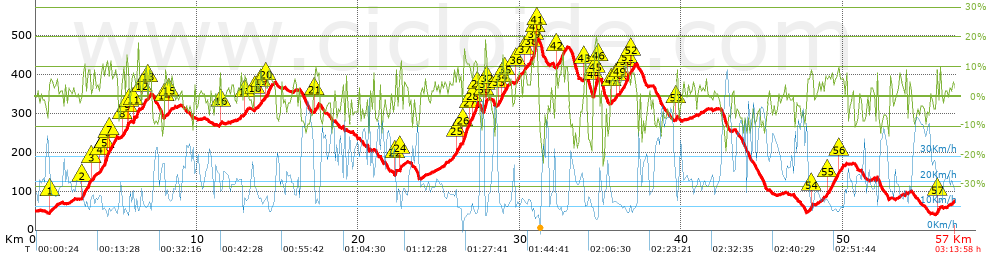
Distance in Km: 56.97
Climb in m: 1551
IBP: 114 BYC

Near ...
Can Roig (Cervello), Cervello, Corbera De Baix, Corbera De Llobregat, Costa De La Perdiu (Cervello), Inter-Club (Vallirana)
Antonio_Ruiz2
653 published routes

Add to my Group or Club

 Height in m      Climb in %      Speed in Km/h      Speed < 2 Km/h

Climbs > 5%

Climbs >5% Climbs >10% Climbs >15% Climbs >20% Climbs >25%
 Steep slope of 189 m.   Average slope  Distances  Download as waypoint
1
 Km 0.904  6%  189 m
 Steep slope of 528 m.  Average slope  Distances  Download as waypoint
2
 Km 2.866  8%  528 m
 Steep slope of 186 m.  Average slope  Distances  Download as waypoint
3
 Km 3.496  6%  186 m
 Steep slope of 453 m.  Average slope  Distances  Download as waypoint
4
 Km 3.983  7%  311 m
5
 Km 4.294  13%  142 m
 Steep slope of 526 m.  Average slope  Distances  Download as waypoint
6
 Km 4.473  7%  72 m
7
 Km 4.545  8%  454 m
 Steep slope of 142 m.  Average slope  Distances  Download as waypoint
8
 Km 5.388  10%  142 m
 Steep slope of 250 m.  Average slope  Distances  Download as waypoint
9
 Km 5.628  13%  144 m
10
 Km 5.773  5%  106 m
 Steep slope of 307 m.  Average slope  Distances  Download as waypoint
11
 Km 6.03  7%  307 m
 Steep slope of 250 m.  Average slope  Distances  Download as waypoint
12
 Km 6.599  7%  250 m
 Steep slope of 169 m.  Average slope  Distances  Download as waypoint
13
 Km 6.999  7%  169 m
 Steep slope of 112 m.  Average slope  Distances  Download as waypoint
14
 Km 8.001  7%  112 m
 Steep slope of 157 m.  Average slope  Distances  Download as waypoint
15
 Km 8.225  5%  157 m
 Steep slope of 104 m.  Average slope  Distances  Download as waypoint
16
 Km 11.433  8%  104 m
 Steep slope of 210 m.  Average slope  Distances  Download as waypoint
17
 Km 12.926  7%  210 m
 Steep slope of 143 m.  Average slope  Distances  Download as waypoint
18
 Km 13.615  5%  143 m
 Steep slope of 222 m.  Average slope  Distances  Download as waypoint
19
 Km 13.936  6%  222 m
 Steep slope of 348 m.  Average slope  Distances  Download as waypoint
20
 Km 14.298  8%  348 m
 Steep slope of 258 m.  Average slope  Distances  Download as waypoint
21
 Km 17.28  7%  258 m
 Steep slope of 116 m.  Average slope  Distances  Download as waypoint
22
 Km 22.262  10%  116 m
 Steep slope of 142 m.  Average slope  Distances  Download as waypoint
23
 Km 22.518  6%  71 m
24
 Km 22.59  14%  71 m
 Steep slope of 289 m.  Average slope  Distances  Download as waypoint
25
 Km 26.076  9%  289 m
 Steep slope of 900 m.  Average slope  Distances  Download as waypoint
26
 Km 26.496  13%  397 m
27
 Km 26.894  7%  184 m
28
 Km 27.078  11%  258 m
29
 Km 27.336  10%  61 m
 Steep slope of 214 m.  Average slope  Distances  Download as waypoint
30
 Km 27.789  18%  108 m
31
 Km 27.897  13%  70 m
32
 Km 27.967  6%  36 m
 Steep slope of 324 m.  Average slope  Distances  Download as waypoint
33
 Km 28.644  8%  257 m
34
 Km 28.901  13%  67 m
 Steep slope of 213 m.  Average slope  Distances  Download as waypoint
35
 Km 29.074  8%  213 m
 Steep slope of 297 m.  Average slope  Distances  Download as waypoint
36
 Km 29.804  7%  297 m
 Steep slope of 223 m.  Average slope  Distances  Download as waypoint
37
 Km 30.247  7%  223 m
 Steep slope of 487 m.  Average slope  Distances  Download as waypoint
38
 Km 30.675  10%  176 m
39
 Km 30.851  18%  141 m
40
 Km 30.992  14%  34 m
41
 Km 31.026  10%  136 m
 Steep slope of 654 m.  Average slope  Distances  Download as waypoint
42
 Km 32.241  8%  654 m
 Steep slope of 106 m.  Average slope  Distances  Download as waypoint
43
 Km 34.017  13%  106 m
 Steep slope of 312 m.  Average slope  Distances  Download as waypoint
44
 Km 34.561  17%  136 m
45
 Km 34.696  14%  140 m
46
 Km 34.836  14%  36 m
 Steep slope of 156 m.  Average slope  Distances  Download as waypoint
47
 Km 35.714  5%  156 m
 Steep slope of 105 m.  Average slope  Distances  Download as waypoint
48
 Km 35.979  6%  105 m
 Steep slope of 583 m.  Average slope  Distances  Download as waypoint
49
 Km 36.191  6%  341 m
50
 Km 36.532  10%  135 m
51
 Km 36.668  11%  107 m
 Steep slope of 258 m.  Average slope  Distances  Download as waypoint
52
 Km 36.882  7%  258 m
 Steep slope of 124 m.  Average slope  Distances  Download as waypoint
53
 Km 39.655  7%  124 m
 Steep slope of 144 m.  Average slope  Distances  Download as waypoint
54
 Km 48.026  9%  144 m
 Steep slope of 681 m.  Average slope  Distances  Download as waypoint
55
 Km 49.021  8%  681 m
 Steep slope of 219 m.  Average slope  Distances  Download as waypoint
56
 Km 49.804  7%  219 m
 Steep slope of 111 m.  Average slope  Distances  Download as waypoint
57
 Km 55.832  10%  111 m


Description of the route


Presence of ramps


 Climbs  Distance  % of the total  Speed  Your speed would be  Time  Your time would be
   15 - 30%  0.635  1.12  7.75  ?  0:04:55  ?
   10 - 15%  2.72  4.77  9.08  ?  0:17:58  ?
   5 - 10%  9.966  17.49  12.53  ?  0:47:43  ?
   1 - 5%  13.657  23.97  16.87  ?  0:48:35  ?
   Total*  26.978 Km  47.36 %  13.58 Km/h  ? Km/h    1:59:11 h  ? h  
 Flat
   1 - -1%  5.562 Km  9.76 %  21.32 Km/h  ? Km/h    0:15:39 h  ? h  
 Descents
   -1 - -5%  11.038  19.37  26.07  ?  0:25:24  ?
   -5 - -10%  9.63  16.9  33.08  ?  0:17:28  ?
   -10 - -15%  2.735  4.8  32.82  ?  0:05:00  ?
   -15 - -30%  1.027  1.8  20.88  ?  0:02:57  ?
   Total*  24.43 Km  42.88 %  28.84 Km/h  ? Km/h    0:50:49 h  ? h  
* The total has not necessarily coincide with the sum of the partials after correction of errors

How long would it take you?

How long would it take you to cover this route?
There are routes without a valid time information, but with your average stats you can assess the possible duration

Antonio_Ruiz2 to cover this route you've need a time of:   3:05:39 h 
If you sign in and have a minimum of two tracks of this same modality, you can know your time for this route, calculated from your stats..


¿Cuanto consumirá tu E-BIKE?

Entra tu E-IBP (formato n,nn)

E-IBP :   X 114 = 


 Detected activity type =  ()
 Penalization due to track conditions: 82 %   ( > 50 % = MTB, < 50 % = RDB)
 Reliability of the track: C   (1551/56/0/-/-/56)
 Correction level applied to the track: 0
DIFFICULTY OF THE ROUTE
IBP = 114 BYC
According to your statistics
 Your time in motion would be: ? h
Your average speed would be: ? Km/h
 

 Total Distance: 56.97 Km
 Analysed distance: 56.97 Km
 Linear distance: 0.07 Km

 Cumulated positive ramps: 1551.2 m  list of points info
 Cumulated negative ramps: 1527.6 m
 Maximum height: 489 m
 Minimum height: 40 m
 Climbing Ratio: 5.75 %
 Descent ratio: 6.25 %
 Cumulated postive ramps per Km: 27.23 m
 Cumulated negative ramps per Km: 26.81 m

 Total time: 3:13:58 h
 Time in movement: 3:05:39 h
 According to your statistics
 Your time in motion would be: ? h  
 Stopped time: 0:08:19 h
 Maximum slope filter: ~30 %
 Minimum separation analysed: ~30 m
 Number of points: 4203   (cad. 13.55 m)
 Significant waypoints: 1575   (cad. 36.17 m / 37.47 %)

 Changes in direction per Km: 11.13
 Changes in direction > 5º por Km: 8.21
 Cumulated straight stretches: 9.431 Km
 Straight stretches per Km: 165.54 m
 Penalized slope changes: 14
 Penalized slope changes per Km: 0.246

 Average speed in total: 17.62 Km/h
 Average speed while moving: 18.41 Km/h
 According to your statistics
 Your average speed would be: ? Km/h  
 Maximum sustained speed: 66.23 Km/h


Comments

You can be the first one in commenting this route

 
My comments
:
Add comment  (Registered users)
 
Notify me answers to my comment  Do not notify answers to my comment


Share this route with a friend

Your friend will receive a message with a link to this page:
will see your email and your user name if you do it as registered user.


Write here your name (optional)

E-mail address of your friend(s). You can include various addresses separated by commas

Text or comment (optional) maximum 255 characters long, 255 Available characters

As a non registered users you need to fill-in the captcha text.
  Change image
Type the image characters.
 
 Share with a friend


Visited history

Delete history

Marked routes for review later or compare

My favorites


  Notify anomaly in this route Share in Facebook