Mejorada Del Campo (Madrid)

MTB
MTB
Ref..: 859975
Published: 19/02/2020
Performed: 18/02/2020
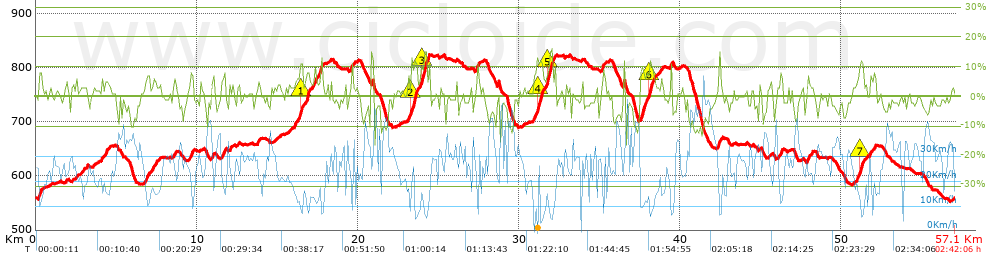
Distance in Km: 57.09
Climb in m: 1110
IBP: 76 BYC


 Height in m      Climb in %      Speed in Km/h      Speed < 2 Km/h

Climbs > 5%

Climbs >5% Climbs >10% Climbs >15% Climbs >20% Climbs >25%
 Steep slope of 208 m.   Average slope  Distances  Download as waypoint
1
 Km 0.182  8%  208 m
 Steep slope of 216 m.  Average slope  Distances  Download as waypoint
2
 Km 4.289  6%  216 m
 Steep slope of 191 m.  Average slope  Distances  Download as waypoint
3
 Km 6.868  7%  191 m
 Steep slope of 254 m.  Average slope  Distances  Download as waypoint
4
 Km 7.292  6%  254 m
 Steep slope of 126 m.  Average slope  Distances  Download as waypoint
5
 Km 8.578  5%  126 m
 Steep slope of 202 m.  Average slope  Distances  Download as waypoint
6
 Km 9.606  8%  202 m
 Steep slope of 247 m.  Average slope  Distances  Download as waypoint
7
 Km 11.545  7%  247 m
 Steep slope of 466 m.  Average slope  Distances  Download as waypoint
8
 Km 16.057  6%  383 m
9
 Km 16.44  12%  83 m
 Steep slope of 188 m.  Average slope  Distances  Download as waypoint
10
 Km 16.828  10%  188 m
 Steep slope of 218 m.  Average slope  Distances  Download as waypoint
11
 Km 17.167  7%  218 m
 Steep slope of 189 m.  Average slope  Distances  Download as waypoint
12
 Km 17.559  6%  189 m
 Steep slope of 105 m.  Average slope  Distances  Download as waypoint
13
 Km 20.848  12%  105 m
 Steep slope of 564 m.  Average slope  Distances  Download as waypoint
14
 Km 23.109  6%  200 m
15
 Km 23.308  12%  296 m
16
 Km 23.604  11%  68 m
 Steep slope of 437 m.  Average slope  Distances  Download as waypoint
17
 Km 23.866  5%  58 m
18
 Km 23.924  11%  268 m
19
 Km 24.192  13%  111 m
 Steep slope of 145 m.  Average slope  Distances  Download as waypoint
20
 Km 27.388  7%  145 m
 Steep slope of 598 m.  Average slope  Distances  Download as waypoint
21
 Km 30.916  6%  224 m
22
 Km 31.139  12%  299 m
23
 Km 31.438  9%  75 m
 Steep slope of 560 m.  Average slope  Distances  Download as waypoint
24
 Km 31.697  7%  64 m
25
 Km 31.761  12%  263 m
26
 Km 32.025  8%  233 m
 Steep slope of 215 m.  Average slope  Distances  Download as waypoint
27
 Km 35.164  6%  215 m
 Steep slope of 899 m.  Average slope  Distances  Download as waypoint
28
 Km 37.514  8%  578 m
29
 Km 38.092  11%  145 m
30
 Km 38.237  8%  176 m
 Steep slope of 146 m.  Average slope  Distances  Download as waypoint
31
 Km 39.387  9%  146 m
 Steep slope of 118 m.  Average slope  Distances  Download as waypoint
32
 Km 42.369  11%  118 m
 Steep slope of 133 m.  Average slope  Distances  Download as waypoint
33
 Km 46.218  8%  133 m
 Steep slope of 141 m.  Average slope  Distances  Download as waypoint
34
 Km 47.894  7%  141 m
 Steep slope of 433 m.  Average slope  Distances  Download as waypoint
35
 Km 50.964  7%  166 m
36
 Km 51.13  10%  198 m
37
 Km 51.328  8%  69 m
 Steep slope of 130 m.  Average slope  Distances  Download as waypoint
38
 Km 51.796  7%  130 m
 Steep slope of 115 m.  Average slope  Distances  Download as waypoint
39
 Km 52.038  7%  115 m


Description of the route


Presence of ramps


 Climbs  Distance  % of the total  Speed  Your speed would be  Time  Your time would be
   15 - 30%  0.107  0.19  6.56  ?  0:00:59  ?
   10 - 15%  2.226  3.9  9.35  ?  0:14:17  ?
   5 - 10%  5.989  10.49  14.32  ?  0:25:06  ?
   1 - 5%  14.894  26.09  20.86  ?  0:42:50  ?
   Total*  23.216 Km  40.67 %  16.74 Km/h  ? Km/h    1:23:12 h  ? h  
 Flat
   1 - -1%  11.187 Km  19.6 %  26 Km/h  ? Km/h    0:25:49 h  ? h  
 Descents
   -1 - -5%  14.021  24.56  29.85  ?  0:28:11  ?
   -5 - -10%  5.939  10.4  28.58  ?  0:12:28  ?
   -10 - -15%  2.508  4.39  37.01  ?  0:04:04  ?
   -15 - -30%  0.216  0.38  32.33  ?  0:00:24  ?
   Total*  22.684 Km  39.74 %  30.17 Km/h  ? Km/h    0:45:07 h  ? h  
* The total has not necessarily coincide with the sum of the partials after correction of errors

How long would it take you?

How long would it take you to cover this route?
There are routes without a valid time information, but with your average stats you can assess the possible duration

Ant._Ariza_Obj._13000_Km to cover this route you've need a time of:   2:34:08 h 
If you sign in and have a minimum of two tracks of this same modality, you can know your time for this route, calculated from your stats..


¿Cuanto consumirá tu E-BIKE?

Entra tu E-IBP (formato n,nn)

E-IBP :   X 76 = 


 Detected activity type =  ()
 Penalization due to track conditions: 60 %   ( > 50 % = MTB, < 50 % = RDB)
 Reliability of the track: B   (1110/62/0/-/-/62)
 Correction level applied to the track: 0
DIFFICULTY OF THE ROUTE
IBP = 76 BYC
According to your statistics
 Your time in motion would be: ? h
Your average speed would be: ? Km/h
 

 Total Distance: 57.09 Km
 Analysed distance: 57.09 Km
 Linear distance: 0.46 Km

 Cumulated positive ramps: 1110.2 m  list of points info
 Cumulated negative ramps: 1110.3 m
 Maximum height: 824.4 m
 Minimum height: 553.1 m
 Climbing Ratio: 4.78 %
 Descent ratio: 4.89 %
 Cumulated postive ramps per Km: 19.45 m
 Cumulated negative ramps per Km: 19.45 m

 Total time: 2:42:06 h
 Time in movement: 2:34:08 h
 According to your statistics
 Your time in motion would be: ? h  
 Stopped time: 0:07:58 h
 Maximum slope filter: ~30 %
 Minimum separation analysed: ~30 m
 Number of points: 2706   (cad. 21.1 m)
 Significant waypoints: 1353   (cad. 42.19 m / 50 %)

 Changes in direction per Km: 9.77
 Changes in direction > 5º por Km: 6.11
 Cumulated straight stretches: 13.527 Km
 Straight stretches per Km: 236.94 m
 Penalized slope changes: 15
 Penalized slope changes per Km: 0.263

 Average speed in total: 21.13 Km/h
 Average speed while moving: 22.22 Km/h
 According to your statistics
 Your average speed would be: ? Km/h  
 Maximum sustained speed: 58.1 Km/h


Comments

You can be the first one in commenting this route

 
My comments
:
Add comment  (Registered users)
 
Notify me answers to my comment  Do not notify answers to my comment


Share this route with a friend

Your friend will receive a message with a link to this page:
will see your email and your user name if you do it as registered user.


Write here your name (optional)

E-mail address of your friend(s). You can include various addresses separated by commas

Text or comment (optional) maximum 255 characters long, 255 Available characters

As a non registered users you need to fill-in the captcha text.
  Change image
Type the image characters.
 
 Share with a friend


Visited history

Delete history

Marked routes for review later or compare

My favorites


  Notify anomaly in this route Share in Facebook