Sin tiempo pa más

MTB
MTB
Ref..: 859846
Published: 19/02/2020
Performed: 18/02/2020
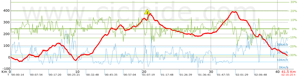
Distance in Km: 41.54
Climb in m: 1037
IBP: 77 BYC

Near ...
Can Roig (Cervello), Cervello, Corbera De Baix, Corbera De Llobregat, Costa De La Perdiu (Cervello), Inter-Club (Vallirana)
Antonio_Ruiz2
653 published routes

Add to my Group or Club

 Height in m      Climb in %      Speed in Km/h      Speed < 2 Km/h

Climbs > 5%

Climbs >5% Climbs >10% Climbs >15% Climbs >20% Climbs >25%
 Steep slope of 278 m.   Average slope  Distances  Download as waypoint
1
 Km 1.658  6%  278 m
 Steep slope of 339 m.  Average slope  Distances  Download as waypoint
2
 Km 2.42  7%  339 m
 Steep slope of 282 m.  Average slope  Distances  Download as waypoint
3
 Km 4.172  8%  282 m
 Steep slope of 284 m.  Average slope  Distances  Download as waypoint
4
 Km 4.545  7%  71 m
5
 Km 4.616  13%  140 m
6
 Km 4.756  10%  73 m
 Steep slope of 281 m.  Average slope  Distances  Download as waypoint
7
 Km 5.543  8%  281 m
 Steep slope of 218 m.  Average slope  Distances  Download as waypoint
8
 Km 6.047  8%  218 m
 Steep slope of 132 m.  Average slope  Distances  Download as waypoint
9
 Km 6.658  7%  132 m
 Steep slope of 348 m.  Average slope  Distances  Download as waypoint
10
 Km 9.761  8%  348 m
 Steep slope of 200 m.  Average slope  Distances  Download as waypoint
11
 Km 10.271  5%  200 m
 Steep slope of 103 m.  Average slope  Distances  Download as waypoint
12
 Km 11.823  6%  103 m
 Steep slope of 1106 m.  Average slope  Distances  Download as waypoint
13
 Km 12.219  8%  72 m
14
 Km 12.291  12%  174 m
15
 Km 12.465  8%  860 m
 Steep slope of 669 m.  Average slope  Distances  Download as waypoint
16
 Km 13.434  10%  178 m
17
 Km 13.612  11%  106 m
18
 Km 13.719  7%  385 m
 Steep slope of 536 m.  Average slope  Distances  Download as waypoint
19
 Km 14.452  7%  179 m
20
 Km 14.631  12%  357 m
 Steep slope of 479 m.  Average slope  Distances  Download as waypoint
21
 Km 15.802  8%  479 m
 Steep slope of 268 m.  Average slope  Distances  Download as waypoint
22
 Km 18.062  6%  268 m
 Steep slope of 105 m.  Average slope  Distances  Download as waypoint
23
 Km 18.773  6%  105 m
 Steep slope of 120 m.  Average slope  Distances  Download as waypoint
24
 Km 19.279  6%  120 m
 Steep slope of 386 m.  Average slope  Distances  Download as waypoint
25
 Km 19.526  11%  101 m
26
 Km 19.627  8%  285 m
 Steep slope of 476 m.  Average slope  Distances  Download as waypoint
27
 Km 20.38  6%  42 m
28
 Km 20.421  14%  74 m
29
 Km 20.495  20%  100 m
30
 Km 20.595  13%  35 m
31
 Km 20.631  8%  225 m
 Steep slope of 154 m.  Average slope  Distances  Download as waypoint
32
 Km 28.617  7%  154 m
 Steep slope of 1013 m.  Average slope  Distances  Download as waypoint
33
 Km 30.762  7%  1013 m
 Steep slope of 325 m.  Average slope  Distances  Download as waypoint
34
 Km 31.888  6%  325 m
 Steep slope of 721 m.  Average slope  Distances  Download as waypoint
35
 Km 32.361  7%  270 m
36
 Km 32.631  10%  134 m
37
 Km 32.766  9%  317 m
 Steep slope of 185 m.  Average slope  Distances  Download as waypoint
38
 Km 37.052  6%  37 m
39
 Km 37.089  12%  148 m


Description of the route


Presence of ramps


 Climbs  Distance  % of the total  Speed  Your speed would be  Time  Your time would be
   15 - 30%  0.24  0.58  7.25  ?  0:01:59  ?
   10 - 15%  1.739  4.19  9.56  ?  0:10:55  ?
   5 - 10%  7.946  19.13  12.24  ?  0:38:58  ?
   1 - 5%  8.018  19.3  16.82  ?  0:28:36  ?
   Total*  17.942 Km  43.19 %  13.38 Km/h  ? Km/h    1:20:28 h  ? h  
 Flat
   1 - -1%  5.581 Km  13.43 %  21.44 Km/h  ? Km/h    0:15:37 h  ? h  
 Descents
   -1 - -5%  9.765  23.51  25.38  ?  0:23:05  ?
   -5 - -10%  5.38  12.95  30.74  ?  0:10:30  ?
   -10 - -15%  2.542  6.12  25.21  ?  0:06:03  ?
   -15 - -30%  0.331  0.8  28.4  ?  0:00:42  ?
   Total*  18.018 Km  43.37 %  26.8 Km/h  ? Km/h    0:40:20 h  ? h  
* The total has not necessarily coincide with the sum of the partials after correction of errors

How long would it take you?

How long would it take you to cover this route?
There are routes without a valid time information, but with your average stats you can assess the possible duration

Antonio_Ruiz2 to cover this route you've need a time of:   2:16:25 h 
If you sign in and have a minimum of two tracks of this same modality, you can know your time for this route, calculated from your stats..


¿Cuanto consumirá tu E-BIKE?

Entra tu E-IBP (formato n,nn)

E-IBP :   X 77 = 


 Detected activity type =  ()
 Penalization due to track conditions: 78 %   ( > 50 % = MTB, < 50 % = RDB)
 Reliability of the track: B   (1036/63/0/-/-/63)
 Correction level applied to the track: 0
DIFFICULTY OF THE ROUTE
IBP = 77 BYC
According to your statistics
 Your time in motion would be: ? h
Your average speed would be: ? Km/h
 

 Total Distance: 41.54 Km
 Analysed distance: 41.54 Km
 Linear distance: 0.01 Km

 Cumulated positive ramps: 1036.8 m  list of points info
 Cumulated negative ramps: 1018.2 m
 Maximum height: 389.8 m
 Minimum height: -36 m
 Climbing Ratio: 5.78 %
 Descent ratio: 5.65 %
 Cumulated postive ramps per Km: 24.96 m
 Cumulated negative ramps per Km: 24.51 m

 Total time: 2:16:25 h
 Time in movement: 2:16:25 h
 According to your statistics
 Your time in motion would be: ? h  
 Stopped time: 0:00:00 h
 Maximum slope filter: ~30 %
 Minimum separation analysed: ~30 m
 Number of points: 3035   (cad. 13.69 m)
 Significant waypoints: 1148   (cad. 36.19 m / 37.83 %)

 Changes in direction per Km: 11.17
 Changes in direction > 5º por Km: 8.09
 Cumulated straight stretches: 7.4 Km
 Straight stretches per Km: 178.14 m
 Penalized slope changes: 11
 Penalized slope changes per Km: 0.265

 Average speed in total: 18.27 Km/h
 Average speed while moving: 18.27 Km/h
 According to your statistics
 Your average speed would be: ? Km/h  
 Maximum sustained speed: 64.94 Km/h


Comments

You can be the first one in commenting this route

 
My comments
:
Add comment  (Registered users)
 
Notify me answers to my comment  Do not notify answers to my comment


Share this route with a friend

Your friend will receive a message with a link to this page:
will see your email and your user name if you do it as registered user.


Write here your name (optional)

E-mail address of your friend(s). You can include various addresses separated by commas

Text or comment (optional) maximum 255 characters long, 255 Available characters

As a non registered users you need to fill-in the captcha text.
  Change image
Type the image characters.
 
 Share with a friend


Visited history

Delete history

Marked routes for review later or compare

My favorites


  Notify anomaly in this route Share in Facebook