St.Feliu-Petit Tourmalet-Gallifa-28-St.LLorenç-Castellar

Road
Road
Ref..: 859445
Published: 16/02/2020
Performed: 16/02/2020
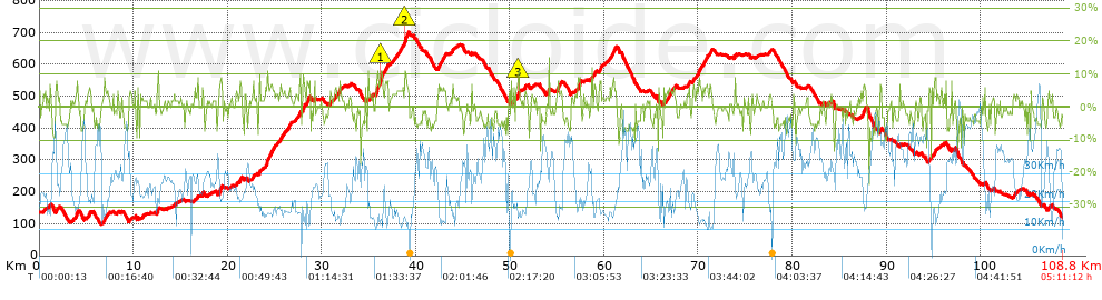
Distance in Km: 108.83
Climb in m: 1838
IBP: 125 BYC

Near ...
Mogoda, Polinya, Santa Perpetua De Mogoda, Santiga (Santa Perpetua De Mogoda)
chen74
Author: chen74
575 published routes

Add to my Group or Club

 Height in m      Climb in %      Speed in Km/h      Speed < 2 Km/h

Climbs > 5%

Climbs >5% Climbs >10% Climbs >15% Climbs >20% Climbs >25%
 Steep slope of 194 m.   Average slope  Distances  Download as waypoint
1
 Km 3.913  8%  194 m
 Steep slope of 213 m.  Average slope  Distances  Download as waypoint
2
 Km 5.217  6%  213 m
 Steep slope of 207 m.  Average slope  Distances  Download as waypoint
3
 Km 6.917  7%  207 m
 Steep slope of 118 m.  Average slope  Distances  Download as waypoint
4
 Km 9.58  6%  118 m
 Steep slope of 188 m.  Average slope  Distances  Download as waypoint
5
 Km 12.534  8%  188 m
 Steep slope of 126 m.  Average slope  Distances  Download as waypoint
6
 Km 17.304  6%  126 m
 Steep slope of 280 m.  Average slope  Distances  Download as waypoint
7
 Km 19.067  6%  280 m
 Steep slope of 145 m.  Average slope  Distances  Download as waypoint
8
 Km 21.348  8%  145 m
 Steep slope of 167 m.  Average slope  Distances  Download as waypoint
9
 Km 23.347  7%  167 m
 Steep slope of 586 m.  Average slope  Distances  Download as waypoint
10
 Km 24.038  7%  586 m
 Steep slope of 204 m.  Average slope  Distances  Download as waypoint
11
 Km 24.748  6%  204 m
 Steep slope of 154 m.  Average slope  Distances  Download as waypoint
12
 Km 25.572  6%  154 m
 Steep slope of 210 m.  Average slope  Distances  Download as waypoint
13
 Km 26.464  7%  210 m
 Steep slope of 219 m.  Average slope  Distances  Download as waypoint
14
 Km 27.587  8%  219 m
 Steep slope of 255 m.  Average slope  Distances  Download as waypoint
15
 Km 27.994  8%  255 m
 Steep slope of 302 m.  Average slope  Distances  Download as waypoint
16
 Km 28.42  6%  302 m
 Steep slope of 148 m.  Average slope  Distances  Download as waypoint
17
 Km 31.448  6%  148 m
 Steep slope of 134 m.  Average slope  Distances  Download as waypoint
18
 Km 31.912  7%  134 m
 Steep slope of 766 m.  Average slope  Distances  Download as waypoint
19
 Km 35.769  8%  501 m
20
 Km 36.271  10%  150 m
21
 Km 36.42  9%  115 m
 Steep slope of 285 m.  Average slope  Distances  Download as waypoint
22
 Km 36.691  6%  285 m
 Steep slope of 433 m.  Average slope  Distances  Download as waypoint
23
 Km 38.784  11%  169 m
24
 Km 38.953  7%  264 m
 Steep slope of 532 m.  Average slope  Distances  Download as waypoint
25
 Km 42.357  6%  532 m
 Steep slope of 287 m.  Average slope  Distances  Download as waypoint
26
 Km 50.64  5%  257 m
27
 Km 50.897  16%  30 m
 Steep slope of 145 m.  Average slope  Distances  Download as waypoint
28
 Km 54.087  11%  145 m
 Steep slope of 232 m.  Average slope  Distances  Download as waypoint
29
 Km 54.999  6%  232 m
 Steep slope of 298 m.  Average slope  Distances  Download as waypoint
30
 Km 57.245  9%  298 m
 Steep slope of 157 m.  Average slope  Distances  Download as waypoint
31
 Km 58.646  8%  157 m
 Steep slope of 184 m.  Average slope  Distances  Download as waypoint
32
 Km 58.941  6%  184 m
 Steep slope of 211 m.  Average slope  Distances  Download as waypoint
33
 Km 59.488  7%  211 m
 Steep slope of 100 m.  Average slope  Distances  Download as waypoint
34
 Km 60.601  6%  100 m
 Steep slope of 276 m.  Average slope  Distances  Download as waypoint
35
 Km 60.823  7%  276 m
 Steep slope of 218 m.  Average slope  Distances  Download as waypoint
36
 Km 66.858  5%  218 m
 Steep slope of 147 m.  Average slope  Distances  Download as waypoint
37
 Km 67.304  5%  147 m
 Steep slope of 111 m.  Average slope  Distances  Download as waypoint
38
 Km 69.005  8%  111 m
 Steep slope of 121 m.  Average slope  Distances  Download as waypoint
39
 Km 69.435  6%  121 m
 Steep slope of 246 m.  Average slope  Distances  Download as waypoint
40
 Km 69.85  6%  246 m
 Steep slope of 140 m.  Average slope  Distances  Download as waypoint
41
 Km 70.229  6%  140 m
 Steep slope of 115 m.  Average slope  Distances  Download as waypoint
42
 Km 70.522  6%  115 m
 Steep slope of 175 m.  Average slope  Distances  Download as waypoint
43
 Km 70.743  6%  175 m
 Steep slope of 214 m.  Average slope  Distances  Download as waypoint
44
 Km 71.228  6%  214 m
 Steep slope of 126 m.  Average slope  Distances  Download as waypoint
45
 Km 73.891  7%  126 m
 Steep slope of 457 m.  Average slope  Distances  Download as waypoint
46
 Km 87.313  5%  457 m
 Steep slope of 215 m.  Average slope  Distances  Download as waypoint
47
 Km 89.311  6%  215 m
 Steep slope of 165 m.  Average slope  Distances  Download as waypoint
48
 Km 94.488  5%  165 m
 Steep slope of 152 m.  Average slope  Distances  Download as waypoint
49
 Km 95.102  9%  152 m


Description of the route


Presence of ramps


 Climbs  Distance  % of the total  Speed  Your speed would be  Time  Your time would be
   15 - 30%  0.108  0.1  16.21  ?  0:00:24  ?
   10 - 15%  1.036  0.95  16.8  ?  0:03:42  ?
   5 - 10%  11.754  10.8  17.66  ?  0:39:56  ?
   1 - 5%  32.77  30.11  21.04  ?  1:33:26  ?
   Total*  45.668 Km  41.96 %  19.93 Km/h  ? Km/h    2:17:28 h  ? h  
 Flat
   1 - -1%  20.352 Km  18.7 %  28 Km/h  ? Km/h    0:43:37 h  ? h  
 Descents
   -1 - -5%  28.277  25.98  32.82  ?  0:51:42  ?
   -5 - -10%  13.227  12.15  36.32  ?  0:21:51  ?
   -10 - -15%  1.102  1.01  31.23  ?  0:02:07  ?
   -15 - -30%  0.203  0.19  40.57  ?  0:00:18  ?
   Total*  42.809 Km  39.34 %  33.81 Km/h  ? Km/h    1:15:58 h  ? h  
* The total has not necessarily coincide with the sum of the partials after correction of errors

How long would it take you?

How long would it take you to cover this route?
There are routes without a valid time information, but with your average stats you can assess the possible duration

chen74 to cover this route you've need a time of:   4:17:03 h 
If you sign in and have a minimum of two tracks of this same modality, you can know your time for this route, calculated from your stats..


¿Cuanto consumirá tu E-BIKE?

Entra tu E-IBP (formato n,nn)

E-IBP :   X 125 = 


 Detected activity type =  ()
 Penalization due to track conditions: 57 %   ( > 50 % = MTB, < 50 % = RDB)
 Reliability of the track: B   (1838/65/0/-/-/65)
 Correction level applied to the track: 0
DIFFICULTY OF THE ROUTE
IBP = 125 BYC
According to your statistics
 Your time in motion would be: ? h
Your average speed would be: ? Km/h
 

 Total Distance: 108.83 Km
 Analysed distance: 108.83 Km
 Linear distance: 0.3 Km

 Cumulated positive ramps: 1838.3 m  list of points info
 Cumulated negative ramps: 1852.2 m
 Maximum height: 699.9 m
 Minimum height: 99 m
 Climbing Ratio: 4.03 %
 Descent ratio: 4.33 %
 Cumulated postive ramps per Km: 16.89 m
 Cumulated negative ramps per Km: 17.02 m

 Total time: 5:11:12 h
 Time in movement: 4:17:03 h
 According to your statistics
 Your time in motion would be: ? h  
 Stopped time: 0:54:09 h
 Maximum slope filter: ~30 %
 Minimum separation analysed: ~30 m
 Number of points: 4919   (cad. 22.12 m)
 Significant waypoints: 2766   (cad. 39.35 m / 56.23 %)

 Changes in direction per Km: 8.74
 Changes in direction > 5º por Km: 6
 Cumulated straight stretches: 27.952 Km
 Straight stretches per Km: 256.84 m
 Penalized slope changes: 18
 Penalized slope changes per Km: 0.165

 Average speed in total: 20.98 Km/h
 Average speed while moving: 25.4 Km/h
 According to your statistics
 Your average speed would be: ? Km/h  
 Maximum sustained speed: 63.89 Km/h


Comments

You can be the first one in commenting this route

 
My comments
:
Add comment  (Registered users)
 
Notify me answers to my comment  Do not notify answers to my comment


Share this route with a friend

Your friend will receive a message with a link to this page:
will see your email and your user name if you do it as registered user.


Write here your name (optional)

E-mail address of your friend(s). You can include various addresses separated by commas

Text or comment (optional) maximum 255 characters long, 255 Available characters

As a non registered users you need to fill-in the captcha text.
  Change image
Type the image characters.
 
 Share with a friend


Visited history

Delete history

Marked routes for review later or compare

My favorites


  Notify anomaly in this route Share in Facebook